


















Lesson 22 of 54 · Pressure, Winds and Circulation
Chapter overview: Pressure, winds and circulation
Preview chapter 5 of the meteorology course: how pressure differences create wind, how Earth's spin bends it, and how the global circulation organizes it.
Wind is the most visible way the atmosphere shows that it is alive. A flag snaps, a kite climbs, a front arrives and the temperature falls ten degrees in an hour. Behind every one of these events is the same simple idea: air is pushed from places where the pressure is high toward places where it is low. The rest of this chapter is about everything that makes that simple idea more interesting. The push is never the whole story. Earth rotates, the ground drags on the air, and the sun heats land and sea unevenly. Together these effects produce the steady trade winds, the westerly storm tracks, the sea breeze on a summer afternoon and the jet stream that airliners ride across oceans.
The big picture
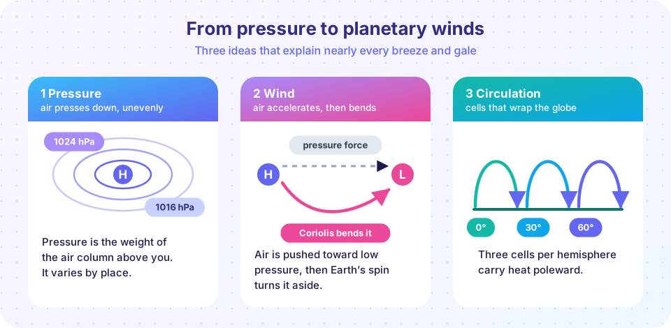
Meteorologists like to separate causes from patterns. The cause of wind is a pressure gradient: a change of pressure over a distance. If pressure were the same everywhere, the air would sit still. The pattern that results depends on what else acts on the air. At the scale of a continent, the Coriolis effect, which comes from Earth's rotation, turns moving air to the right in the Northern Hemisphere and to the left in the Southern Hemisphere. At the scale of a coastline, the contrast in heating between land and water matters more. At the scale of the whole planet, the contrast between the hot equator and the cold poles drives a system of overturning cells.
You will meet these scales in order, from the smallest idea to the largest. First you learn what pressure is and how a weather map shows it. Then you add the forces that act on a moving parcel of air and discover why wind blows along lines of constant pressure instead of across them. After that you zoom out to the whole planet, and finally zoom back in to the local winds you can feel on your own skin.
Air has weight
Pressure falls as you climb.
Air is pushed
Planet-wide pattern
Local winds
What each lesson covers
- Pressure and the pressure gradient force explains where pressure comes from, why it drops with height, how stations correct their readings to sea level, and how to read isobars on a map.
- The Coriolis effect and geostrophic wind adds Earth's rotation and the balance of forces that produces wind parallel to the isobars. You will calculate a real wind speed from a pressure map.
- Global circulation cells builds the three-cell model, the trade winds, the westerlies and the jet streams, and explains why the pattern follows from conservation of angular momentum.
- Sea breezes and local winds shows how uneven heating creates breezes on coasts and in mountains, and how air descending a mountain can warm dramatically.
- Chapter review pulls everything into one picture and tests it with ten questions.
Why this chapter matters for the rest of the course
Winds are the delivery system of weather. Air masses, which you will study in the next chapter, are carried by the wind. Fronts form where winds from different sources collide. A forecast model is, at heart, a machine for computing how pressure and wind evolve. Even climate patterns such as monsoons and El Niño are circulation patterns. Master the logic of this chapter and many later topics will feel like variations on a theme you already know.
Try it
The first demo converts between the pressure units you will meet in weather reports. Different countries and different media use hectopascals, millibars, inches of mercury and kilopascals, and you should be able to move between them without hesitation.
Check your understanding
Quick check · 3 questions
of 3 answered You scored / 3 · perfect!
-
1. What is the direct cause of wind?
Air is pushed from higher toward lower pressure. Rotation and friction modify the motion but do not start it. -
2. Which unit is most common for pressure on weather maps worldwide?
One hectopascal equals 100 pascals and one millibar. Standard sea-level pressure is about 1013 hPa. -
3. In which order does this chapter move through scales?
The chapter builds from the physics of a single parcel of air, to the global circulation, and then back to local effects.
Summary
- Wind is air moving from high toward low pressure.
- Rotation, friction and uneven heating shape where the air actually goes.
- The chapter covers pressure, forces, the three-cell global pattern and local winds.
- Later chapters on fronts and forecasting rely on the ideas introduced here.
Track your progress
Create a free account to tick off lessons and pick up where you left off on any device.
of Meteorology lessons completed