


















Lesson 26 of 54 · Pressure, Winds and Circulation
Sea breezes and local winds
See how uneven heating creates sea and land breezes, mountain and valley winds, and warm downslope winds such as the foehn and chinook, with calculators.
You do not need a planet-sized circulation to make wind. Anywhere that one patch of ground heats up faster than its neighbor, the air above it expands, rises, and draws cooler air in at the surface. A beach, a mountain slope and a city all do exactly this. These local winds are small compared with a hurricane, but they shape daily life: they cool coastal cities in summer, trigger afternoon thunderstorms, blow smoke and pollution across valleys, and occasionally melt a foot of snow in a day. This lesson covers the main kinds, the physics that links them, and the numbers you can calculate.
What you will learn
- Explain why land and water heat at different rates.
- Describe the sea breeze and land breeze cycle, including timing, speed and the sea-breeze front.
- Distinguish anabatic, katabatic, valley and mountain winds.
- Calculate the warming of air that descends the lee side of a mountain (foehn effect).
Key terms
Sea breeze is the wind blowing from sea to land on a sunny day. Land breeze is the weaker reverse flow at night. Anabatic wind is a wind flowing up a slope heated by the sun. Katabatic wind is cold dense air flowing downslope under gravity. Foehn wind is a warm, dry wind descending a mountain's lee side; the chinook is its North American cousin.
Why land and sea behave differently
Land and water receive the same sunshine, yet land gets hot and water barely changes. Four reasons add up.
- Heat capacity. Water needs about 4,186 joules to warm 1 kg by one kelvin; dry soil and rock need roughly 800 to 1,000. Per kilogram, water warms about four to five times less.
- Mixing. Waves and currents spread the heat down tens of meters. On land, heat only penetrates a few centimeters in a day, so it piles up at the surface.
- Transparency. Sunlight penetrates the upper meters of water instead of being absorbed in a thin skin.
- Evaporation. Water surfaces use much of the incoming energy to evaporate water, which keeps them cooler.
The outcome: on a clear summer day the land surface may warm by 10 to 20 K, while the sea surface changes by less than 1 K. The air above the land, heated from below, expands and the pressure surfaces tilt: at some height the pressure is higher over land than over sea.
The sea breeze cycle
By late morning the temperature difference is large enough to start the flow. The sequence is as follows.
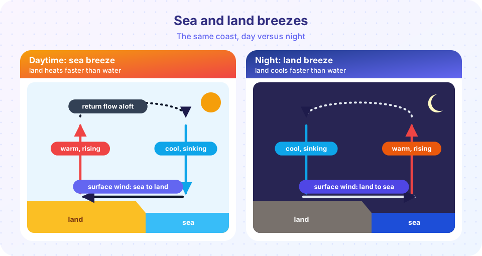
- Warm air over land rises. At several hundred meters it flows toward the sea (the return flow aloft).
- The surface pressure over land falls slightly relative to the sea, so a cool, moist breeze flows from the sea to the land.
- The breeze strengthens through the afternoon, reaching 3 to 8 m/s (about 6 to 15 knots) and penetrating 10 to 50 km inland on a typical day, further under favorable conditions.
- At the leading edge there is a sea-breeze front, where cool marine air meets warm land air. The temperature may drop several degrees in minutes, the wind veers and gusts, and a line of cumulus clouds often marks the front. Where two fronts collide, as on a peninsula such as Florida, thunderstorms are common.
- After sunset, the land cools quickly. By night the land is colder than the sea and the circulation reverses: a land breeze blows seaward, weaker (1 to 3 m/s) because the temperature contrast is smaller and the cold surface layer is shallow.
Because the Coriolis force acts over hours, a sea breeze that lasts into the evening turns gradually to the right (Northern Hemisphere), so late in the day it blows more along the coast than straight inland. Lakes produce the same effect on a smaller scale: a lake breeze can make a city on the shore ten degrees cooler than a suburb inland.
Press Run (or Ctrl + Enter) to see the result here.
Program input · what you'd type while the program runs
Type the answers before you press Run, one per line. Each time the program reads a line (with input()), it gets the next line from this box.
Mountain and valley winds
The same logic works on slopes. By day, sunlit slopes warm the air in contact with them faster than free air at the same height. This lighter air rises up the slope as an anabatic wind (upslope, valley wind), often feeding cumulus clouds over the ridges. By night, the slope radiates heat to space and cools. The cold air is denser and flows downhill as a katabatic wind, also called a mountain wind or drainage wind, and pools in valley bottoms. This is why frost hollows exist and why fog fills valleys at dawn. Mountain climbers feel these winds in the morning and evening.
On a much larger scale, katabatic flow off the ice sheets of Antarctica and Greenland produces some of the strongest and most persistent surface winds on Earth, because the cold air accelerates over hundreds of kilometers of slope. The bora of the Adriatic coast is a cold downslope wind that can gust beyond 40 m/s.
Foehn and chinook winds
When a moist airflow is forced over a mountain range, it rises on the windward side. The air cools at the dry adiabatic lapse rate of about 9.8 K per kilometer until it reaches saturation, at the lifting condensation level. A good estimate for that level is LCL ≈ 125 m × (T − Td), where T is the temperature and Td the dew point in °C. Above the LCL, condensation releases latent heat and the air cools more slowly, at a moist adiabatic rate, typically 4 to 7 K/km. Rain or snow falls out on the windward side. On the lee side the now-dry air sinks and warms at the dry rate of 9.8 K/km all the way down. It arrives warmer than it began, and much drier. This is the foehn in the Alps and the chinook (a name meaning "snow eater") east of the Rockies. Temperature rises of 20 °C or more within a few hours are documented, and the Santa Ana wind of Southern California is a related downslope wind that carries hot, dry desert air toward the coast.
Worked example
Air at sea level has T = 20 °C and Td = 12 °C. It crosses a 3,000 m ridge.
- LCL = 125 × 8 = 1,000 m.
- Temperature at the LCL = 20 − 9.8 = 10.2 °C.
- From 1,000 m to 3,000 m, use a moist rate of 6 K/km: 10.2 − 6 × 2 = −1.8 °C at the crest.
- Descending 3,000 m dry: −1.8 + 9.8 × 3 = 27.6 °C at sea level on the lee side.
The air has gained 7.6 °C by crossing the range, because latent heat was released on the way up and precipitation removed the moisture.
Press Run (or Ctrl + Enter) to see the console output here.
No output.
Common misconceptions
"A sea breeze blows because cold air is pulled toward warm air." The pressure falls where the warmed air column is lighter, and the pressure force pushes the denser sea air inland. "The foehn wind is warm because it comes from a warm place." It is warm because air sinks 3,000 m or more and compresses, and because latent heat was released on the way up. "Sea breezes blow all day and night." They reverse when the land becomes colder than the sea.
Check your understanding
Quick check · 5 questions
of 5 answered You scored / 5 · perfect!
-
1. Which explains why land heats faster than the sea?
Water warms about four times less per kilogram and spreads heat downward, so the sea surface barely changes in a day. -
2. A sea breeze blows
By day warm air rises over land, and cooler marine air flows in at the surface. The reverse happens at night. -
3. What is a katabatic wind?
Katabatic means descending. Air cooled on the slope is denser than its surroundings and flows downhill. -
4. Air at 20 C, dew point 12 C. What is its approximate LCL?
The LCL is about 125 m times the temperature-dew point spread: 125 x 8 = 1,000 m. -
5. Why is the leeward foehn air warmer than the windward air at the same height?
Condensation warms the rising air, the moisture is lost, and the air then descends at the larger dry lapse rate.
Summary
- Differences in heating create local pressure differences and winds.
- Sea breeze by day, land breeze by night; the front can trigger storms.
- Anabatic winds flow up slopes by day, katabatic winds drain down at night.
- Foehn and chinook winds are warm and dry because of latent heat gain and descent at 9.8 K/km.
- The LCL estimate
125 m × (T − Td)and lapse rates let you calculate the effect.
Track your progress
Create a free account to tick off lessons and pick up where you left off on any device.
of Meteorology lessons completed