


















Lesson 30 of 54 · Air Masses, Fronts and Storms
Cold fronts, warm fronts and occlusions
Understand how fronts form, what cold, warm, stationary and occluded fronts look like in cross-section and on a map, and the weather sequence as each one passes.
If you watch a barometer and a thermometer for a few days in a mid-latitude city, you will see that changes rarely come gradually. The temperature may hold steady for two days, then drop eight degrees in an hour. The wind may swing around, the sky turn from patchy cloud to a dark wall, and a short heavy shower arrive. Such sudden shifts mark the passage of a front. Because the contrast in air density across a front is large, fronts are the main places where air is lifted, clouds form and precipitation falls. This lesson explains how fronts are built, what weather they bring, and how to spot them from simple observations.
What you will learn
- Define a front and explain why it slopes.
- Describe the structure and weather sequence of cold, warm, stationary and occluded fronts.
- Recognize fronts in surface observations: pressure, temperature, dew point, wind.
- Read the standard front symbols on a weather map.
Key terms
Front is the sloping boundary between two air masses of different density. Frontal zone is the transition region, usually tens of kilometers wide. Veering is a clockwise shift in wind direction (Northern Hemisphere). Occlusion is the stage when a cold front overtakes a warm front and lifts the warm air off the ground. Trough is an elongated area of lower pressure; fronts lie along troughs.
Why fronts slope
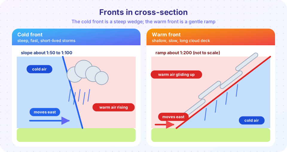
Cold air is denser than warm air. When the two meet side by side, the cold air spreads out underneath like a wedge, and the warm air is forced above it. The boundary is therefore not vertical but tilted, with the cold air on the low side. The slope is gentle: a warm front rises roughly 1 km in 150 to 200 km (a slope of about 1:200), and a cold front rises about 1 km in 50 to 100 km. Even a "steep" cold front is as shallow as a ramp built from a single sheet of paper, which is why the diagrams in this lesson are drawn with an exaggerated vertical scale.
Fronts are also places where the wind changes. Because the front lies along a trough of low pressure, the winds on the two sides converge on the line and shift direction as the front passes. Convergence forces air upward, and rising air cools, condenses and forms cloud. Where lifting is strong and the warm air is moist and unstable, you get thunderstorms. Where lifting is gentle, you get layers of cloud and steady rain.
Cold front
The cold air advances, behaving like a snow plow. The steep leading edge lifts the warm air abruptly, giving narrow bands of heavy rain, often with thunder, hail and gusts. The usual signs as it approaches and passes:
- Before the front. Warm, humid air with southwesterly winds in the Northern Hemisphere. Pressure falls slowly. Towering cumulus builds in the distance, sometimes with a line of storms 100 km or more ahead of the front.
- At the front. The wind veers sharply, often to the west or northwest, and gusts. Pressure bottoms out and begins to rise. Rain or thunderstorms for 30 minutes to a few hours.
- After the front. The sky clears quickly. Temperature drops by several degrees to 10 degrees or more, and the dew point drops too. Pressure rises steadily. Visibility is excellent in dry cold air, and showers may continue if the air behind is unstable.
Cold fronts move quickly, typically 30 to 50 kilometers per hour, and can catch up with warm fronts ahead of them.
Warm front
At a warm front, warm air advances over the retreating cold air. The long gentle ramp produces a wide cloud shield extending several hundred kilometers ahead of the surface position of the front, and the weather evolves slowly over 12 to 24 hours:
- High cirrus thin and wispy, often 800 to 1,000 km ahead of the surface front.
- Cirrostratus, a veil that creates a halo around the sun or moon.
- Altostratus, a gray sheet that dims the sun to a pale disc.
- Nimbostratus, a thick, dark layer with steady rain or snow for many hours, reducing visibility.
- Passage. Rain stops and the wind veers from southeast to south or southwest. Temperature rises several degrees and the humidity increases. Pressure, which was falling steadily, levels off. Low stratus or fog may remain in the warm sector.
In winter, a warm front can bring freezing rain where rain falls from the warm layer above into a very cold layer near the ground.
Stationary and occluded fronts
A stationary front is one that is not moving, with winds on both sides blowing nearly parallel to the front. Clouds and light rain may last for days along it, and the front frequently begins to move as a wave develops on it.
An occluded front forms when a cold front, which moves faster than the warm front ahead of it, catches up and merges with it. The warm air between them is squeezed upward and lifted off the ground. Two types occur. In a cold occlusion, the air behind the cold front is colder than the air ahead of the warm front, and the cold front undercuts the cool air ahead. In a warm occlusion, the air behind the cold front is milder than the air ahead of the warm front, and the cold front rides up over the warm front's cool air. Weather at an occlusion combines features of both: wide cloud shields and rain, often the heaviest precipitation of a storm's life.
Reading the symbols
| Front | Color and symbol | Direction |
|---|---|---|
| Cold | Blue line with triangles | Triangles point the way the front moves |
| Warm | Red line with semicircles | Semicircles point the way the front moves |
| Stationary | Alternating blue triangles and red semicircles on opposite sides | No motion |
| Occluded | Purple line with alternating triangles and semicircles on the same side | Toward the side with symbols |
Press Run (or Ctrl + Enter) to see the result here.
Program input · what you'd type while the program runs
Type the answers before you press Run, one per line. Each time the program reads a line (with input()), it gets the next line from this box.
Spotting a front in the data
Meteorologists rarely see a front; they infer it. The strongest clues are:
- A temperature gradient across a short distance, often 5 to 10 degrees over 100 km or less. Dew point changes may be even clearer, because moisture contrasts persist when temperature contrasts are masked by sunshine.
- A wind shift, with the wind turning clockwise (veering) as a front passes.
- A pressure trough: pressure falls as the front approaches and rises afterward (cold front) or levels off (warm front).
- Cloud and precipitation bands on satellite and radar images.
The most visible sign is a line on the radar loop: a thin line of storms ahead of a cold front is called a squall line.
Press Run (or Ctrl + Enter) to see the console output here.
No output.
Common misconceptions
"Cold fronts always bring storms." Whether a front produces storms depends on how much moisture and instability the warm air has. A dry front can pass with only a wind shift and a cold snap. "Warm fronts bring warm weather ahead of them." The weather before a warm front is cool, cloudy and wet, and warmth arrives only after it passes. "A front is a thin line on the ground." It is a sloping surface through the atmosphere; the surface position is just where it meets the ground.
Check your understanding
Quick check · 5 questions
of 5 answered You scored / 5 · perfect!
-
1. Which front is a steep wedge that lifts warm air abruptly?
At a cold front the cold air pushes under the warm air in a steep wedge, so the lifting is rapid and often creates storms. -
2. The cloud sequence ahead of a warm front is
Warm air gliding gently up the ramp produces layered clouds, thickening as the front approaches. -
3. After a cold front passes in the Northern Hemisphere, the wind typically
The wind turns clockwise as the front moves past, and the temperature and dew point fall. -
4. An occluded front forms when
The faster cold front catches the warm front, and the warm air between them is lifted off the ground. -
5. A front is best described as
Fronts slope, with the cold air forming a wedge underneath. They lie along pressure troughs.
Summary
- A front is a sloping boundary between air masses of different density; cold air lies underneath.
- Cold fronts are steep and fast, with a narrow band of heavy showers and a quick clearing.
- Warm fronts are shallow and slow, with a long cloud sequence and steady rain.
- Stationary fronts stall, occluded fronts form when a cold front overtakes a warm one.
- Fronts are identified by temperature and dew-point contrasts, wind veer and pressure troughs.
Next: Mid-latitude cyclones
Track your progress
Create a free account to tick off lessons and pick up where you left off on any device.
of Meteorology lessons completed