


















Lesson 29 of 54 · Air Masses, Fronts and Storms
Air masses and source regions
Learn how air masses are classified as arctic, polar, tropical, continental or maritime, where they form, and how they change as they travel across new surfaces.
A forecast that says "a cold air mass will settle over the region" is making a promise about several days of weather in a few words. An air mass is a huge body of air, often 1,000 kilometers or more across and several kilometers deep, whose temperature and humidity are roughly the same at any given height from one end to the other. Because it carries its properties with it, an air mass is a kind of weather package: pick the package and you know what is probably inside. This lesson shows how meteorologists name the packages, where they come from, and how they change on their journey.
What you will learn
- Define an air mass and explain what makes a good source region.
- Use the classification letters (A, P, T; c, m; k, w) correctly.
- Name typical source regions and the weather each air mass brings.
- Explain how air masses are modified and why stability changes.
Key terms
Air mass is a large body of air with fairly uniform temperature and moisture. Source region is the surface where it acquires its properties. Continental (c) air forms over land and is dry; maritime (m) air forms over water and is moist. Modification is the change in an air mass as it moves over new surfaces. Stability is the tendency of air to resist vertical motion.
How an air mass is born
For an air mass to form, the air must stay over one surface long enough, typically several days, to reach a balance with it. Two conditions help. The surface must be fairly uniform, like a snow-covered plain, a big desert or an ocean, and the air must be nearly stagnant, which happens under the center of a large anticyclone where winds are light. Under those conditions the lowest kilometer or two gradually warms or cools toward the surface temperature, and picks up or loses moisture through evaporation or condensation. Regions that satisfy both conditions are the source regions: the Arctic ice and snow, the interiors of Siberia and Canada, the subtropical oceans, the Sahara and the Gulf of Mexico. Mountainous or highly varied terrain makes a poor source region, and the mid-latitude belt of westerlies, where the weather changes every few days, makes the poorest of all.
The classification system
The scheme in use today goes back to the Norwegian meteorologist Tor Bergeron, who in 1928 proposed a two- or three-letter code based on source region.
First letter, the moisture of the surface: lowercase c for continental (dry) and m for maritime (moist). Second letter, the temperature of the source region: uppercase A for arctic or Antarctic, P for polar, T for tropical, and in some schemes E for equatorial. A third letter, k or w, compares the air with the ground it is moving over: k (from the German kalt) means colder than the surface, w (warm) means warmer than the surface.
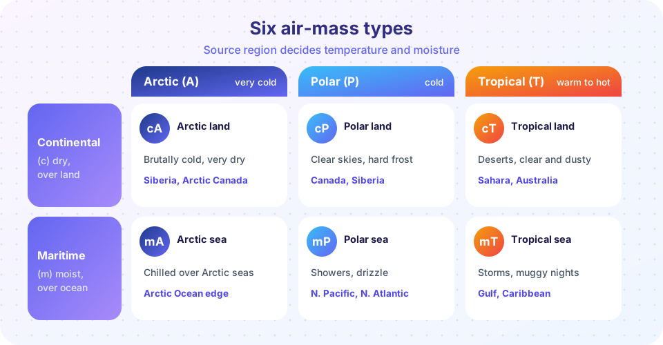
Putting these together gives the six standard types:
| Code | Name | Typical properties | Example source regions | Typical weather |
|---|---|---|---|---|
| cA | Continental arctic | Extremely cold, very dry, very stable | Arctic ice, Siberia, northern Canada in winter | Bitter cold, clear skies |
| cP | Continental polar | Cold, dry, stable in winter | Interior Canada, Siberia | Cold clear days, hard frost, little precipitation |
| mP | Maritime polar | Cool, moist, often unstable | North Pacific, North Atlantic | Showers, drizzle, cloud |
| cT | Continental tropical | Hot, very dry | Sahara, Arabian Peninsula, Mexican desert | Heat waves, dust, clear skies |
| mT | Maritime tropical | Warm, humid, unstable | Gulf of Mexico, Caribbean, subtropical oceans | Thunderstorms, muggy nights, fog in cool seasons |
| mA | Maritime arctic | Cold, moist | Arctic Ocean edge | Snow showers |
Moisture is best judged from the dew point. mT air in a North American summer commonly has dew points of 20 °C or more, which makes the air feel oppressive, while cP air in winter can have dew points far below freezing.
Where they go: North America, Europe, Asia
North America. In winter, cP air plunges south from Canada across the Great Plains in outbreaks that can bring temperatures below −20 °C to the central United States. Pacific mP air arrives on the west coast and, after losing moisture over the mountains, crosses the continent as mild, dry air. Atlantic mP air feeds the cool, damp weather and the nor'easters of the northeast. In summer, mT air from the Gulf of Mexico flows north on the western side of the Bermuda High and supplies the moisture for central US thunderstorms. cT air from the southwestern deserts occasionally bakes the southern plains.
Europe. The prevailing westerlies bring maritime polar and maritime tropical air from the Atlantic, so the weather is mild and changeable. Continental air arrives less often but with a strong effect: Saharan cT air produces summer heat waves and carries dust and sometimes reddish rain, while Siberian cP air in winter, such as the one that gave the "Beast from the East" of 2018, brings hard frost.
Asia. The giant Siberian anticyclone in winter pumps very cold, dry cP and cA air south and east. In summer the monsoon brings mT or equatorial air from the Indian Ocean to South Asia, with the heavy rains that agriculture depends on.
Air mass modification
As an air mass moves, the surface beneath it changes, and so does the air. The cases below are the ones that most often explain real weather.
- Cold air over warm water or land (k type). The lowest layers are heated from below, so they become unstable. They pick up moisture by evaporation. Result: cumulus clouds and showers. The classic example is lake-effect snow, where cold cP air crosses the relatively warm Great Lakes and drops heavy bands of snow on the downwind shores, sometimes more than a meter in a day.
- Warm air over a cold surface (w type). The lowest layers cool, so the air becomes stable and mixing stops. Moisture condenses into low stratus cloud, fog and drizzle. Warm mT air flowing over cold ground in spring or over cold ocean currents near the coast of California or Peru is a textbook case of advection fog.
- Heating over land by day. Even without crossing a boundary, a day of strong sunshine can turn a stable air mass unstable and trigger afternoon showers and thunderstorms.
- Subsidence. Sinking air under a high pressure center warms and dries, so the air mass becomes more stable.
The python example below is a toy model, not a measurement. It lets cold air relax toward the temperature of a lake as it crosses, and shows why the air near the lake surface can hold more water vapor by the time it reaches the far shore.
Press Run (or Ctrl + Enter) to see the result here.
Program input · what you'd type while the program runs
Type the answers before you press Run, one per line. Each time the program reads a line (with input()), it gets the next line from this box.
Common misconceptions
"An air mass is a layer of the sky." It is a body of air hundreds to thousands of kilometers wide that keeps its identity as the wind moves it. "Maritime means warm and continental means cold." Maritime refers to moisture. Maritime polar air is cold, and continental tropical air is hot. "Air masses never change." They are modified continuously, and the label describes where the air came from, not what it is like after several days of travel.
Check your understanding
Quick check · 5 questions
of 5 answered You scored / 5 · perfect!
-
1. What does the letter m in mT stand for?
Lowercase c and m describe the source surface: continental (dry) and maritime (moist). -
2. Which air mass most likely brings a heat wave and dust to Europe?
Continental tropical air from the Sahara is hot and dry and can carry desert dust. -
3. What is a good source region?
Air must stay over a uniform surface for days to acquire its properties, which happens under slow-moving high pressure. -
4. Cold air flows across a warm lake. The lowest layer becomes
Heating and moistening from below makes the air unstable, and cumulus clouds or lake-effect snow develop. -
5. A warm air mass moving over a cold surface is called
w means warmer than the surface. It becomes stable and tends to produce stratus cloud, fog and drizzle.
Summary
- Air masses are large uniform bodies of air shaped by their source regions.
- The classification uses c or m for moisture, A, P, T for temperature, and k or w for stability relative to the ground.
- Typical examples are cP, mP, cT and mT, each with a characteristic weather.
- Modification over new surfaces changes stability, moisture and the weather they bring.
Track your progress
Create a free account to tick off lessons and pick up where you left off on any device.
of Meteorology lessons completed