


















Lesson 44 of 54 · Severe Weather and Climate Links
El Nino, La Nina and teleconnections
Learn how El Nino and La Nina rearrange the tropical Pacific, how they shift weather worldwide, and how other teleconnections such as the NAO and MJO affect seasons.
Weather forecasts lose their skill after about two weeks, but some parts of the climate system are slow enough to be predicted months ahead. The most important of these is a swing of the tropical Pacific Ocean and the atmosphere above it, known as the El Niño–Southern Oscillation, or ENSO. A change of a degree or two in the sea surface temperature of a patch of the equatorial Pacific shifts rainfall over the entire Pacific Rim, alters the path of the jet stream over North America, changes the strength of the Indian monsoon and modifies the number of Atlantic hurricanes. This is a teleconnection: a link between weather in places thousands of kilometers apart. In this lesson you will learn how ENSO works, how it is measured, what it does around the world and how other patterns work in a similar way.
What you will learn
- Describe the Walker circulation and the neutral state of the Pacific.
- Explain how El Niño and La Niña develop through ocean–atmosphere feedback.
- Use the Niño 3.4 index and the ONI to classify events.
- List typical regional impacts and the limits of those patterns.
Key terms
ENSO is the El Niño–Southern Oscillation, an irregular cycle in the tropical Pacific. Walker circulation is the east-west overturning of air along the equatorial Pacific. Thermocline is the layer where the ocean temperature drops quickly with depth. Niño 3.4 is the region (5° N to 5° S, 170° W to 120° W) used to monitor ENSO. Teleconnection is a statistical link between climate in distant regions.
The neutral Pacific
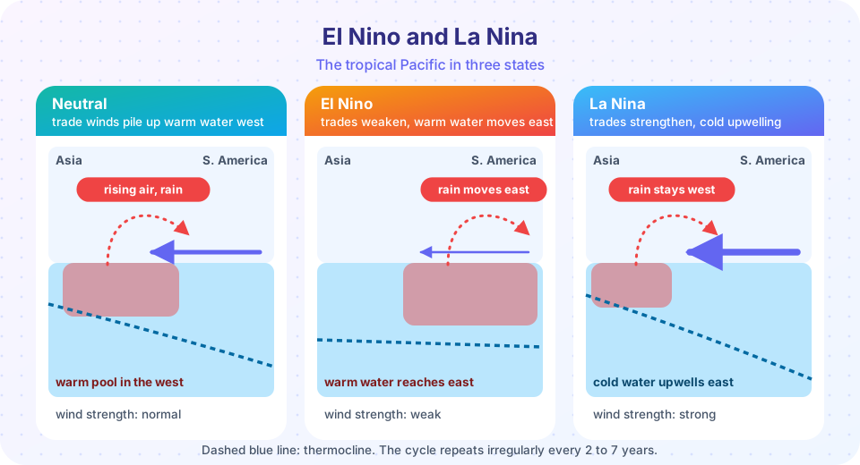
In a normal state, the trade winds blow from east to west along the equator, dragging warm surface water westward. The result is a warm pool of 29 to 30 °C water near Indonesia and the western Pacific, and cool water in the east, where deep cold water upwells along the coast of South America. Sea level in the west is higher than in the east by tens of centimeters, and the thermocline is deep in the west and shallow in the east.
The warm pool heats the air above it, so air rises there and makes huge amounts of rain. At the top of the troposphere, the air flows eastward, sinks over the cooler eastern Pacific, and returns westward along the surface as the trade winds. This loop is the Walker circulation, named after the British scientist Gilbert Walker, who in the 1920s discovered a seesaw in surface pressure between the eastern and western Pacific that he called the Southern Oscillation. It is the basis of the whole system.
The feedback that makes ENSO
In the 1960s Jacob Bjerknes explained that the ocean and the atmosphere in the tropical Pacific are coupled in a positive feedback loop. Suppose the trade winds weaken a little. Less warm water is pushed west, so the warm pool spreads east and the sea surface of the central and eastern Pacific warms. A warmer surface there reduces the east-west temperature difference that drives the trade winds, so the trade winds weaken further, and warming grows. This is the Bjerknes feedback. The system does not run away forever, because slow processes in the ocean, such as waves that travel along the equator and slowly change the heat content, eventually reverse the swing, which is why events end and ENSO oscillates irregularly with a period of two to seven years.
- El Niño is the warm phase. Peruvian fishermen gave it the name, which means "the Christ child", because the warm water often appears around Christmas. The trade winds weaken, the warm pool spreads east, the thermocline flattens, upwelling off South America is reduced, and the main area of rain moves toward the central Pacific.
- La Niña is the cool phase. The trade winds strengthen, upwelling is intense, the east is unusually cool, and the rain zone is confined to the far west.
- Neutral is the state between the two.
Measuring ENSO
The most widely used measure is the Niño 3.4 index, the average sea surface temperature anomaly (the departure from the long-term normal) in the Niño 3.4 box. NOAA's Oceanic Niño Index (ONI) is the 3-month running average of that anomaly. An El Niño event is declared when the ONI is at or above +0.5 °C for at least five consecutive overlapping 3-month periods, and a La Niña when it is at or below −0.5 °C. Strong events exceed ±1.5 °C. The 1997–98 and 2015–16 El Niños were among the strongest on record. A companion atmospheric measure is the Southern Oscillation Index (SOI), which is based on the surface pressure difference between Tahiti and Darwin, Australia. Negative SOI values go with El Niño.
Press Run (or Ctrl + Enter) to see the result here.
Program input · what you'd type while the program runs
Type the answers before you press Run, one per line. Each time the program reads a line (with input()), it gets the next line from this box.
Impacts around the world
ENSO shifts the areas of tropical rain, and the shifted tropical heating changes the atmospheric waves that reach the middle latitudes, nudging the jet stream. The result is a set of tendencies, not certainties. In any individual event some regions behave differently from the usual pattern, and the size of the effect varies from event to event.
| Region | Typical El Niño tendency | Typical La Niña tendency |
|---|---|---|
| Coastal Ecuador and northern Peru | Heavy rain, floods | Dry |
| Indonesia, northern and eastern Australia | Dry, drought and fire risk | Wetter, flood risk |
| Southern United States in winter | Wetter, cooler | Drier, warmer, drought risk |
| Northern United States, southern Canada in winter | Milder | Colder |
| Atlantic hurricane season | Quieter (more shear) | More active |
| Eastern and central Pacific hurricanes | More active | Less active |
| Southern Africa, northern Brazil | Drier | Wetter in many areas |
| South Asian monsoon | Tendency to weaken | Tendency to strengthen |
| Global average temperature | Higher, peaking a few months after the event | Slightly lower |
Because an El Niño can be spotted months before its main effects, forecast centers issue seasonal outlooks that help farmers, water managers and disaster planners. Often the effects of ENSO are described as "loading the dice": the probabilities of wet or dry, warm or cold, shift, but any single season can still go the other way because of random weather.
Other teleconnections
ENSO is the biggest but not the only one.
- North Atlantic Oscillation (NAO). A seesaw in pressure between the subtropical high near the Azores and the subpolar low near Iceland. In its positive phase the pressure difference is large, the westerlies are strong, and northern Europe has mild, wet winters, while the Mediterranean is dry. In the negative phase the westerlies weaken and cold air can spill over Europe and eastern North America. Unlike ENSO, the NAO changes from week to week and is only partly predictable.
- Madden–Julian Oscillation (MJO). A pulse of enhanced tropical rain that moves eastward around the world every 30 to 60 days. It affects tropical cyclone activity, the monsoon and the weather in the mid-latitudes two to four weeks ahead, which makes it a main source of predictability on that time scale.
- Indian Ocean Dipole (IOD) and Pacific Decadal Oscillation (PDO). The IOD is a difference in sea temperature across the Indian Ocean that affects East Africa and Australia. The PDO is a slow, decades-long pattern of North Pacific temperatures that modulates ENSO's effects.
All of these share an idea: slowly changing conditions in the ocean or the tropical atmosphere set the stage on which the faster weather plays out.
Common misconceptions
"El Niño causes the weather events of a season." It shifts probabilities, and events such as a particular storm still depend on day-to-day weather. "El Niño is just warm water off Peru." It is a coupled ocean-atmosphere event that involves the winds, pressure and rain of the whole tropical Pacific. "Every El Niño has the same effects." The location of the warming (eastern versus central Pacific) changes the pattern. "ENSO is caused by climate change." It is a natural cycle, though climate change may modify its effects.
Check your understanding
Quick check · 5 questions
of 5 answered You scored / 5 · perfect!
-
1. During El Nino, the trade winds
Weaker trades let the warm pool spread east, which in turn weakens the winds further (the Bjerknes feedback). -
2. The ONI threshold for El Nino is
NOAA requires five overlapping seasons at or above +0.5 C in the Nino 3.4 region. -
3. A typical El Nino impact is
The rain zone moves east, leaving the western Pacific dry. -
4. The Walker circulation is
Air rises over the warm western Pacific, flows east aloft, sinks in the east and returns west along the surface. -
5. The MJO is a
It is an eastward-moving pulse of convection that affects weather on time scales of two to four weeks.
Summary
- The neutral Pacific has strong trade winds, a western warm pool and eastern upwelling, tied together by the Walker circulation.
- ENSO is a coupled ocean-atmosphere cycle with a positive Bjerknes feedback; events come every two to seven years.
- The Niño 3.4 index and ONI classify El Niño and La Niña at plus or minus 0.5 °C.
- Impacts are tendencies: wetter or drier, warmer or cooler, more or fewer hurricanes depending on region.
- Other teleconnections, such as the NAO and MJO, link distant weather on other time scales.
Track your progress
Create a free account to tick off lessons and pick up where you left off on any device.
of Meteorology lessons completed