


















Lesson 19 of 54 · Moisture, Clouds and Precipitation
Clouds: how they form and how to name them
Learn how clouds form from cooling air and condensation nuclei, how the ten cloud genera are named by height and shape, and what each cloud type tells you about the weather.
Look up on any day and you read a page of the atmosphere's diary. A thin silky veil means moist air is rising high above you. Flat grey sheets mean slow, widespread lifting. Heaped white cauliflowers mean thermals are working below an unstable sky. A dark tower with an anvil means a thunderstorm. This lesson explains how a cloud forms from invisible vapor and gives you the naming system that meteorologists have used for two centuries to read the sky.
What you will learn
- How cloud droplets form and why they need tiny particles called condensation nuclei
- Why clouds are white or grey and what they are made of
- The ten cloud genera and how to tell them apart by height and shape
- What different clouds and fog types suggest about the weather
Key terms
- Cloud is a visible mass of tiny liquid droplets, ice crystals, or both, suspended in air.
- Condensation nuclei (CCN) are microscopic particles such as sea salt, dust or sulfate on which droplets form.
- Genus is the basic cloud type, such as cumulus or stratus; the International Cloud Atlas recognizes ten.
- Fog is a cloud in contact with the ground, reducing visibility below 1 km.
- Liquid water content is the mass of liquid water per cubic meter of cloud air, typically 0.1 to 0.5 g/m³.
How a cloud forms
A cloud forms when air is cooled below its dew point, the temperature at which it is saturated. Usually the cooling comes from lifting (previous lesson), but it can also happen by radiative cooling near the ground (fog) or by mixing warm moist air with cold air (the breath you see on a winter day).
Here is a surprise: in perfectly clean air, vapor does not condense at 100 percent humidity. Droplets would need a relative humidity of several hundred percent to form, because very small droplets have a strongly curved surface which lets molecules escape easily. Real air is full of condensation nuclei: sea salt from ocean spray, mineral dust, smoke and sulfate particles. These dissolve in water and provide a surface where vapor condenses at a humidity within a fraction of a percent of 100. A cubic centimeter of air holds from about 50 (clean marine air) to over 1000 (polluted continental air) of them. Each nucleus grows into a cloud droplet about 10 to 20 µm across, just 1/50th of a millimeter, which is far too small to fall: such a droplet drops at only about 1 cm per second and is kept aloft by the slightest updraft.
Typical cloud droplet numbers are 100 to 500 per cm³, and the liquid water content is only 0.1 to 0.5 g per m³ of cloud. A cloud that looks like a mountain of water is, on a mass basis, mostly air: a large cumulus 1 km across might hold several hundred tonnes of water, but that is spread over a billion cubic meters.
Clouds look white because droplets are large compared with the wavelength of light, so they scatter all colors equally (Mie scattering). Thick clouds look grey or dark at the base because so much light is scattered or absorbed on the way through that little reaches the bottom.
Droplets stay liquid even below freezing. At temperatures between 0 and about −38 °C, cloud droplets can exist as supercooled water, which freezes on contact with an ice nucleus or with an aircraft wing. Below about −38 °C, pure water droplets freeze spontaneously. High clouds are therefore made of ice crystals, low warm clouds of droplets, and mid-level or deep clouds of both.
Naming the clouds
The system was devised in 1802 by the English amateur meteorologist Luke Howard, who used Latin names, and it is maintained today by the World Meteorological Organization. Four root words are combined:
| Word | Meaning | Applied to |
|---|---|---|
| cirrus / cirro- | curl of hair; high, fibrous | high clouds |
| alto- | middle | mid-level clouds |
| stratus / strato- | layer, spread out | sheet-like clouds |
| cumulus / cumulo- | heap | puffy clouds with vertical growth |
| nimbus / nimbo- | rain | clouds that give precipitation |
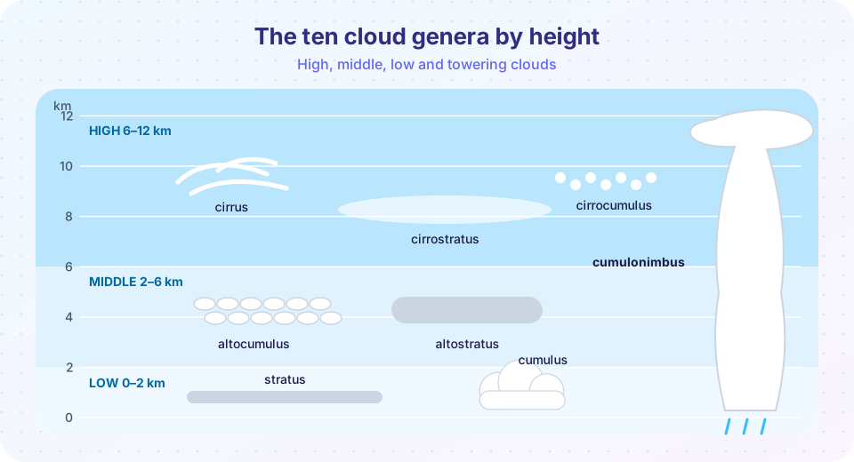
By height, the ten genera divide into three levels, plus clouds with great vertical extent. The heights below are typical for mid-latitudes; in the tropics everything is shifted upward and at the poles downward.
| Level | Genus | Appearance |
|---|---|---|
| High (about 6 to 12 km) | Cirrus | Thin white fibers or wisps |
| Cirrostratus | Transparent veil; halo around the Sun or Moon | |
| Cirrocumulus | Tiny white ripples ("mackerel sky") | |
| Middle (about 2 to 6 km) | Altocumulus | White or grey patches or rolls |
| Altostratus | Grey-blue sheet; the Sun looks like through frosted glass | |
| Low (below about 2 km) | Stratus | Uniform grey sheet; fog that has lifted; drizzle |
| Stratocumulus | Grey and white lumps in a layer | |
| Nimbostratus | Thick dark layer, steady rain or snow | |
| Vertical | Cumulus | Detached heaps with flat bases; fair-weather types |
| Cumulonimbus | Giant towers with anvils; storms, hail |
What clouds tell you
- Cirrus thickening into cirrostratus and then altostratus, with a lowering base, often comes ahead of a warm front, a sign that rain may arrive within about 12 to 24 hours.
- Small, scattered cumulus in a blue sky at midday, shrinking in the evening, means fair weather and shallow thermals.
- Towering cumulus (cumulus congestus) with sharp tops growing quickly means strong instability. Cumulonimbus follows, with showers and possibly thunder.
- Altocumulus in a warm humid morning is sometimes a sign of afternoon thunderstorms.
- Lenticular clouds, smooth lens-shaped clouds, sit downwind of mountains, in waves of air.
- Contrails are clouds made by jet exhaust and cold humid air at flight height; if they stay long and spread, the upper air is humid.
Satellites see clouds from the top. Cloud-top temperature, measured in the infrared, gives the height: cold tops are high. Cloud cover is described in oktas, as in the station model.
Fog
Fog is simply stratus at the ground. Its types are named by how the air gets saturated:
- Radiation fog forms on clear, calm nights when the ground cools by radiation and chills the air to its dew point; it burns off in the morning.
- Advection fog forms when warm moist air flows over a cold surface, such as a cold sea current; San Francisco and the Grand Banks are famous for it.
- Upslope fog forms when air is lifted up a gentle slope and cools.
- Steam fog appears when cold air flows over warmer water, such as a lake in autumn.
Press Run (or Ctrl + Enter) to see the result here.
Program input · what you'd type while the program runs
Type the answers before you press Run, one per line. Each time the program reads a line (with input()), it gets the next line from this box.
Clouds and climate
Clouds cover about two thirds of the planet at any time. Low, thick clouds reflect sunlight and cool the surface, while high, thin cirrus let sunlight through and trap infrared, warming it (Chapter 3). Whether a warming climate will have more or less of each cloud type is one of the largest uncertainties in climate projections. For weather forecasting, the useful skill is to read the cloud type, its height and its change, and combine it with pressure, temperature and wind.
Common misconceptions
"Clouds are floating water vapor." Clouds are made of droplets and crystals, which are condensed water. The vapor itself is invisible.
"Cloud droplets fall slowly because clouds are light." They are heavy compared with air, but they are so tiny, and their fall speed so small (about 1 cm/s), that updrafts keep them suspended.
"Dark clouds always mean rain." Dark bases mean the cloud is thick, and thick clouds may or may not be producing precipitation. A thin, dark-looking stratus layer may be dry.
Check your understanding
Quick check · 5 questions
of 5 answered You scored / 5 · perfect!
-
1. Why do clouds usually need condensation nuclei?
Without nuclei, droplets would need very high supersaturation to form; salt, dust and smoke particles let them form near 100 percent humidity. -
2. Which cloud genus is a high, thin, transparent veil that can produce a halo?
Cirrostratus is a thin ice-crystal veil, and light refracted through its crystals makes a halo. -
3. The prefix nimbo- or suffix -nimbus means
Nimbus is Latin for rain cloud. -
4. A typical cloud droplet is about
Cloud droplets are typically 10 to 20 µm across, which is about 0.02 mm. -
5. Which fog forms on clear, calm nights as the ground cools?
Radiation fog forms when the ground cools by radiation and chills the air to its dew point.
Summary
- Clouds form when air is cooled to its dew point; condensation nuclei let droplets form at near 100 percent humidity.
- Cloud droplets are about 10 to 20 µm across and too small to fall, which is why clouds float.
- The ten genera are grouped as high (cirro-), middle (alto-), low (strato-) and vertical (cumulo-, nimbo-).
- Cloud type, height and change are clues to stability, fronts and coming weather.
- Fog is cloud at ground level, named by how the air is saturated.
Next: How precipitation forms
Track your progress
Create a free account to tick off lessons and pick up where you left off on any device.
of Meteorology lessons completed