


















Lesson 32 of 54 · Air Masses, Fronts and Storms
Thunderstorm development
Learn the three ingredients of thunderstorms, how parcel theory and CAPE measure instability, the life cycle of a storm cell, and how lightning and thunder arise.
On a hot, humid afternoon a small puffy cloud grows into a tower that is taller than Mount Everest, goes dark at its base, and in under an hour delivers a downpour, lightning and a gust of cold wind. At any moment roughly 2,000 thunderstorms are active somewhere on Earth, and lightning flashes occur roughly 40 or more times every second. Thunderstorms are small compared with cyclones, yet they cause some of the most dangerous weather: flash floods, hail, damaging straight-line winds and tornadoes. This lesson explains what a thunderstorm needs, how the amount of energy in the air can be measured, how a storm cell lives and dies, and where lightning and thunder come from.
What you will learn
- State the three ingredients every thunderstorm needs.
- Explain parcel theory, the LFC, the equilibrium level and CAPE.
- Describe the life cycle of a single-cell thunderstorm and how storms organize.
- Explain how lightning forms and use the flash-to-bang method to find its distance.
Key terms
Instability is a state in which a lifted parcel becomes warmer than its surroundings and keeps rising. CAPE (convective available potential energy) is the energy available to a rising parcel, in J/kg. LFC (level of free convection) is the height above which the parcel is warmer than its surroundings. Downdraft is a column of sinking, rain-cooled air. Gust front is the leading edge of cool outflow from a storm.
The three ingredients
A thunderstorm needs all of the following. Remove one and the storm fails.
- Moisture. Warm, humid air near the ground supplies the water vapor that condenses and releases latent heat. Dew points of 15 °C or more are typical for strong storms in the mid-latitudes, and higher in the tropics.
- Instability. The atmosphere must be arranged so that a parcel of air lifted high enough will keep rising on its own. That happens when the temperature falls with height faster than the parcel's own cooling rate.
- Lift. Something has to push the air upward far enough to reach the level where it starts rising freely. Lift is provided by fronts, sea-breeze fronts, mountains, outflow boundaries from earlier storms, or simply strong daytime heating of the ground.
A fourth ingredient controls the type of storm rather than whether it forms: wind shear, the change of wind speed and direction with height. Weak shear gives short-lived storms; strong shear gives long-lived, organized ones, including the supercells covered in chapter 8.
Parcel theory, LFC and CAPE
To judge instability, forecasters imagine lifting a small parcel of surface air without mixing with its surroundings and compare its temperature with the environment at each height.
- Up to the lifting condensation level (LCL) the parcel cools at the dry rate of 9.8 K/km. Above it, condensation releases heat and it cools more slowly, at the moist-adiabatic rate, about 4 to 7 K/km in the lower atmosphere and approaching the dry rate in the very cold upper troposphere.
- At first the parcel is usually colder than the surroundings, so it resists lifting. This negative buoyancy is the cap or convective inhibition.
- At the level of free convection (LFC) the parcel becomes warmer than its environment and accelerates upward.
- It continues until it reaches the equilibrium level (EL), near the top of the storm, where it is again as cold as its surroundings.
The energy gained between the LFC and the EL is
CAPE = ∫ g (T_parcel − T_env) / T_env dz
in joules per kilogram. If all of it were converted to kinetic energy, the updraft speed would be w = √(2 · CAPE). A CAPE of 2,000 J/kg gives a theoretical maximum of about 63 m/s. Real updrafts are weaker, typically about half the theoretical value, because the rising air mixes with its surroundings and the falling rain drags it down. Values below about 500 J/kg are weak, 1,000 to 2,500 J/kg moderate, and above 2,500 J/kg are strongly unstable. Meteorologists also use the lifted index, the difference between the environment's temperature at 500 hPa and the lifted parcel's temperature there: more negative means more unstable.
The python TryIt below integrates a parcel numerically through a simplified sounding. The environment is a straight temperature profile with a chosen lapse rate and a stratosphere that stays at −56.5 °C, and the parcel follows the dry rate up to the LCL and then the full moist-adiabatic rate. It is a classroom model, not an operational forecast tool.
Press Run (or Ctrl + Enter) to see the result here.
Program input · what you'd type while the program runs
Type the answers before you press Run, one per line. Each time the program reads a line (with input()), it gets the next line from this box.
Try changing Td0 to 10 (dry air) or gamma to 5.5 (a stable environment) and run again. You should find CAPE collapses: dry air raises the LCL so far that the parcel never gets buoyant, and a stable environment removes the instability.
Life cycle of a single-cell storm
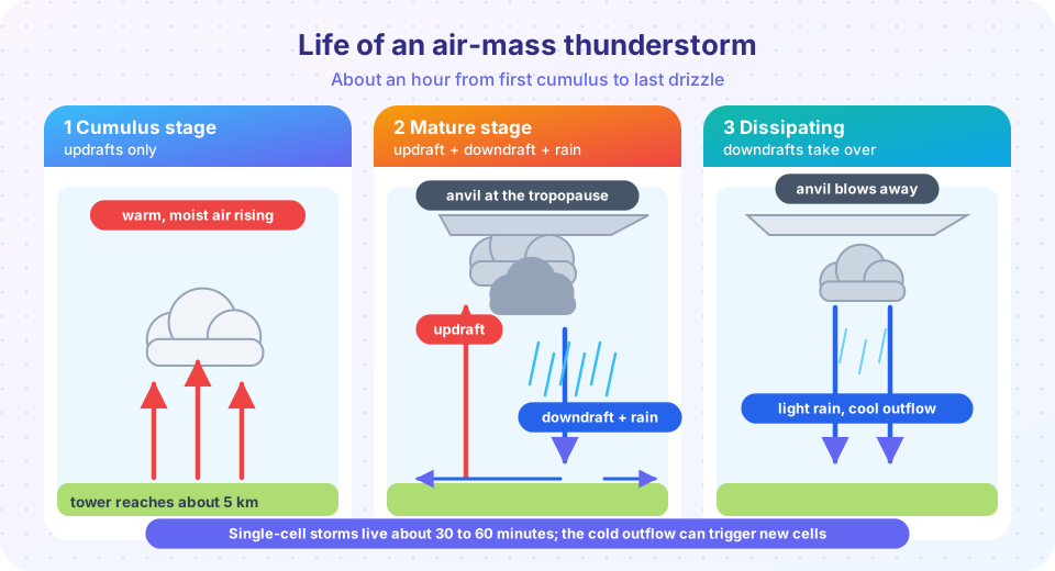
A single cell is one updraft-downdraft unit. The classic air-mass storm, which forms in weakly sheared environments such as a humid summer afternoon, goes through three stages in 30 to 60 minutes.
- Cumulus stage. Warm moist air rises in a growing tower. Updrafts dominate throughout the cell, there is no rain at the ground yet, and the cloud may reach 5 to 8 km.
- Mature stage. Precipitation forms and begins to fall. The falling rain drags air downward, producing a downdraft, and evaporating rain cools the air further. Updraft and downdraft coexist. The cloud top reaches the tropopause, where it spreads out into an anvil, and this stage has the heaviest rain, hail, lightning and strongest gusts.
- Dissipating stage. The downdraft spreads through the whole cell and cuts off the warm air supply. The storm decays into light rain, and the anvil drifts away.
The cold downdraft spreading outward along the ground is the gust front. It can trigger new cells on its flanks, which is how single cells become multicell clusters that last for hours. Lines of cells that form on a gust front or cold front become a squall line, with a wide trailing shield of rain behind a narrow band of strong winds. A microburst, a small and intense downdraft less than 4 km wide, can produce dangerous winds for aircraft landing near a storm.
Lightning and thunder
How does a cloud become electrified? Inside the storm, in the region between about −10 and −40 °C, ice crystals, small hail pellets called graupel, and supercooled water droplets all coexist. When graupel collides with ice crystals, charge is transferred: the graupel usually becomes negatively charged and falls to the middle of the cloud, while the lighter crystals gain positive charge and are carried to the top. The result is a main positive charge region at the top, a main negative region in the middle, and often a small positive region near the base.
When the electric field grows large enough, a faint channel called a stepped leader extends downward from the negative region toward the ground in short jumps. Upward streamers rise from tall objects to meet it. When contact occurs, a return stroke surges up the channel with a peak current of tens of thousands of amperes, heating the air to about 30,000 K, several times hotter than the surface of the Sun. That sudden heating makes the air expand explosively, which produces the sound wave we call thunder. Most lightning stays within or between clouds and never reaches the ground.
Light travels almost instantly, but sound takes about 2.9 seconds to cover one kilometer. Count the seconds between the flash and the thunder and divide by about three to get the distance in kilometers (or by five for miles). Safety agencies advise seeking shelter in a building or a hard-topped vehicle whenever you hear thunder, and waiting 30 minutes after the last thunder before going out again.
Common misconceptions
"Lightning never strikes the same place twice." It strikes tall structures repeatedly; the Empire State Building is hit about 20 to 25 times a year. "No rain, no danger." Lightning can strike up to 15 km or more from the rain core, so a bolt can come "from the blue". "Heat lightning is a different kind of lightning." It is ordinary lightning from a storm too far away for its thunder to be heard.
Check your understanding
Quick check · 5 questions
of 5 answered You scored / 5 · perfect!
-
1. Which is NOT one of the three basic ingredients of a thunderstorm?
The ingredients are moisture, instability and lift. A cold current does not feed storms. -
2. CAPE is measured in
CAPE is an energy per unit mass of the rising parcel. -
3. In which stage of a single-cell thunderstorm do updraft and downdraft coexist?
The mature stage has rising air feeding the storm and rain-cooled sinking air together, along with the heaviest weather. -
4. You count 9 seconds between flash and thunder. About how far away is the lightning?
Sound travels about 1 km in 3 seconds, so 9 seconds is about 3 km. -
5. What triggers new storm cells beside an old one?
The gust front lifts nearby warm air, which can trigger additional cells and produce multicell clusters or squall lines.
Summary
- Thunderstorms need moisture, instability and lift; wind shear determines the storm type.
- Parcel theory gives the LFC, EL and CAPE; the theoretical updraft is
√(2 CAPE). - A single cell lives 30 to 60 minutes: cumulus, mature (updraft and downdraft), dissipating.
- Gust fronts trigger new cells, producing multicell clusters and squall lines.
- Lightning comes from charge separation among ice particles; thunder is the sound of the superheated channel, about 3 seconds per kilometer.
Track your progress
Create a free account to tick off lessons and pick up where you left off on any device.
of Meteorology lessons completed