


















Lesson 46 of 54 · Severe Weather and Climate Links
Chapter review: Severe weather and climate links
Review chapter 8 of the meteorology course: supercells and tornadoes, hurricanes, floods, heat and winter storms, ENSO and climate change, with a recap table and a ten-question quiz.
This chapter took the building blocks of the course and pushed them to their limits. You saw that a tornado is a rotating column that needs both energy and shear, that a hurricane is a heat engine running on a warm ocean, and that floods, heat waves and winter storms follow from the structure of rain, ridges and temperature profiles. You also saw how slow climate rhythms such as El Niño change where these hazards strike, and how warming changes the odds. The picture below puts the whole chapter on one page, and the recap table and quiz help you check what you remember.
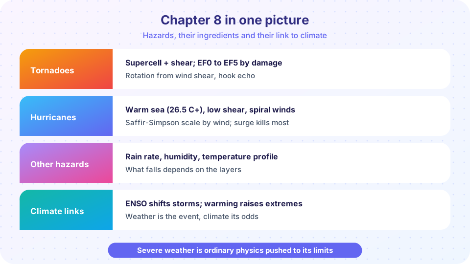
The chapter in one picture
Each row of the poster pairs a hazard with its ingredients. Tornadoes need instability (CAPE) and wind shear that turns with height, which organizes a thunderstorm into a rotating supercell. Hurricanes need warm water of at least 26.5 °C, low shear, moisture and distance from the equator. Floods need a lot of water in a short time on ground that cannot absorb it, heat waves need persistent ridges, and winter storms need cold air and the right temperature profile. The bottom row is the link to climate: El Niño and La Niña move the rain and storm tracks, and warming adds water vapor and shifts temperature extremes.
Recap table
| Topic | Key facts |
|---|---|
| Supercell | Strong CAPE plus strong turning shear (0-6 km bulk shear about 20 m/s or more); rotating updraft (mesocyclone) |
| Features | Wall cloud, rear-flank downdraft, hook echo, anvil |
| Tornado rating | EF0 to EF5 by damage; 65 mph to over 200 mph; most are EF0 or EF1 |
| Watch versus warning | Watch: conditions favorable. Warning: occurring or imminent |
| Tropical cyclone ingredients | SST 26.5 °C or more, low shear, moist air, at least about 5° latitude, a disturbance |
| Structure | Eye (sinking air), eyewall (strongest wind), spiral rainbands; warm core |
| Saffir–Simpson | Category 1 74 to 95 mph, up to Category 5 at 157 mph or more |
| Biggest killer | Storm surge, then inland rain flooding |
| Return period | P = 1 − (1 − 1/T)ⁿ; a 100-year flood has a 26% chance in 30 years |
| Heat | Ridges, dry soil, hot nights; heat index combines temperature and humidity |
| Winter precipitation | Snow, sleet, freezing rain, rain, set by the temperature profile |
| ENSO | Weak trades and a warm east in El Niño, strong trades and a cool east in La Niña; ONI of ±0.5 °C |
| Climate and weather | Normal is 30 years; Clausius–Clapeyron gives 6 to 7% more vapor per °C |
| Attribution | Compare the world with and without warming: PR and FAR |
Try it
Winds do damage through the force they exert on structures, and the dynamic pressure of the wind grows with the square of its speed: q = ½ ρ v². The code shows what that means for the scales you learned: a Category 4 hurricane or EF4 tornado does not do twice the damage of a weaker one, it exerts several times the pressure.
Press Run (or Ctrl + Enter) to see the result here.
Program input · what you'd type while the program runs
Type the answers before you press Run, one per line. Each time the program reads a line (with input()), it gets the next line from this box.
Common misconceptions
"Wind speed is all that matters for a hurricane." Surge and rain kill more people. "Warming means more of every hazard." The evidence is strong for heat and heavy rain, mixed for tornadoes, and uncertain for storm frequency. "A watch and a warning are the same." A watch means be ready; a warning means act now.
Check your understanding
Quick check · 10 questions
of 10 answered You scored / 10 · perfect!
-
1. Which two ingredients most clearly separate a supercell from an ordinary thunderstorm?
Supercells need large CAPE and shear that turns with height so the updraft rotates and tilts. -
2. The Enhanced Fujita scale rates tornadoes by
Damage indicators are used to estimate the peak wind, so ratings are assigned after the event. -
3. Which sea surface temperature is the usual minimum for tropical cyclone formation?
About 26.5 C or more over a deep layer provides the heat and moisture. -
4. A storm with sustained winds of 125 mph is a
Category 3 covers 111 to 129 mph. -
5. Which hazard has historically been the leading cause of tropical cyclone deaths?
Surge drowns coastal residents; inland flooding from rain is also a major killer. -
6. Freezing rain forms when
The drops are liquid until they hit a surface at or below 0 C and freeze on contact. -
7. During El Nino the trade winds are
Weaker trades let the warm pool and rain move east. -
8. A 50-year flood has what chance of occurring in a given year?
The annual probability is 1 divided by the return period: 1/50 = 2 percent. -
9. Warmer air holds about how much more water vapor per degree Celsius?
That is the Clausius-Clapeyron rate at typical temperatures. -
10. What does a probability ratio of 3 in an attribution study mean?
PR = P1 / P0 compares the probability in today's climate with the counterfactual.
Summary
- Severe hazards each have ingredients: CAPE and shear, warm ocean and low shear, intense or repeated rain, persistent ridges, cold-layer structure.
- Scales (EF, Saffir–Simpson) rate wind, but surge and rain flooding do much of the harm.
- ENSO and other teleconnections shift where hazards occur; warming raises the baseline for heat and heavy rain.
- Attribution compares today's climate with a counterfactual to speak about odds, not blame.
- The last chapter applies the whole course in projects and practice.
Track your progress
Create a free account to tick off lessons and pick up where you left off on any device.
of Meteorology lessons completed