


















Lesson 3 of 54 · Getting Started
Observing the weather: instruments and standards
See how weather is measured: shaded thermometers, barometers, anemometers, rain gauges, balloons, radar and satellites, and why standard exposure makes data comparable.
Every forecast, every climate record and every weather map begins with a measurement. If the measurements are poor, nothing built on top of them can be trusted. This lesson tours the instruments that measure the basic weather variables, explains the rules that make readings from different places comparable, and then looks up and out: balloons, radar and satellites that observe the atmosphere in three dimensions.
What you will learn
- Which instrument measures each basic weather variable and in what units
- Why instruments are placed in standard positions, such as a shaded screen at 1.25 to 2 m
- How upper-air and remote sensing observations complement surface stations
- How averaging and sampling change what a wind or rain reading means
Key terms
- Exposure is how an instrument is placed: height, shading, ventilation and distance from obstacles.
- Stevenson screen is a white, louvered wooden box that shields a thermometer from sunshine and rain while letting air flow through.
- Radiosonde is a small instrument package carried up by a balloon that measures pressure, temperature, humidity and wind.
- Remote sensing means measuring from a distance, for example by radar or from satellites.
- UTC (Coordinated Universal Time) is the time standard used for weather observations worldwide.
Temperature
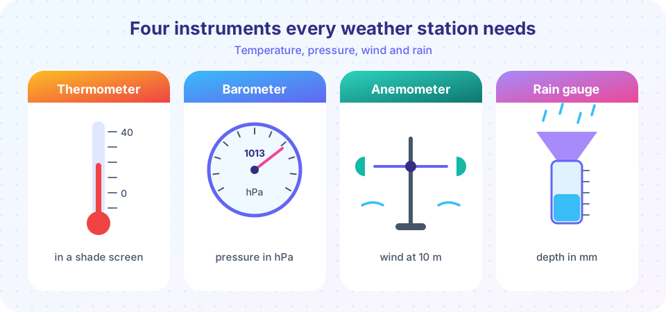
Air temperature is measured with a thermometer. The traditional type is a liquid-in-glass thermometer filled with mercury or colored alcohol, but most modern stations use electrical sensors such as platinum resistance thermometers, whose resistance changes predictably with temperature. Maximum and minimum thermometers record the highest and lowest values since they were last reset, which is how daily extremes were collected for more than a century.
The sensor must measure the temperature of the air, not of the sunshine hitting the sensor. In direct sun a thermometer can read several degrees too warm. So the standard is to place it in a Stevenson screen, or a modern ventilated radiation shield, at a height of 1.25 to 2 m above short grass, away from buildings and pavement. Compare that with a thermometer nailed to a sunny wall, which tells you about the wall.
Pressure
Air pressure is measured with a barometer. The first barometer, made by Evangelista Torricelli in 1643, is a tube of mercury standing in a dish: the weight of the atmosphere pushing on the dish supports a column about 760 mm tall at sea level. That gives the old unit "millimeters of mercury". Meteorologists today report pressure in hectopascals (hPa), where 1 hPa = 100 Pa, and standard sea-level pressure is 1013.25 hPa. An older name for the hectopascal is the millibar (1 mb = 1 hPa), still used in many forecasts. Most stations now use electronic sensors that sense the flex of a tiny sealed capsule (the principle of the aneroid barometer, which uses a metal capsule and a pointer).
Pressure at a station depends on its height, so weather maps use sea-level pressure, which corrects the reading to what it would be at sea level. You will see why in Chapter 2.
Wind
Wind has a speed and a direction. A cup anemometer has three or four cups on arms that spin faster in stronger wind, and a wind vane points into the wind. Sonic anemometers measure how wind changes the travel time of sound between sensors and have no moving parts. By international convention the wind is measured at 10 m above open, level ground, and the reported speed is the mean over the previous 10 minutes. A gust is a short peak, typically the highest 3-second average.
Wind direction is always the direction the wind comes from. A "westerly" blows from the west toward the east. It is given in degrees clockwise from north: 90 degrees is east, 180 is south, 270 is west.
Precipitation
A rain gauge is a funnel above a measuring tube. Because the funnel is wider than the tube, a small depth of rain collects as a larger depth in the tube, which is easier to read. The result is reported as a depth in millimeters. One millimeter of rain means that if the water could not run off or soak in, it would cover the ground to a depth of 1 mm, which is one liter of water on each square meter. Tipping-bucket gauges count how many times a small see-saw bucket fills and tips; each tip is a fixed amount such as 0.2 mm, so the tips can be logged automatically and turned into a rain rate.
Snow is measured by melting it to find its water equivalent, and by measuring depth. Fresh snow is typically about ten times as deep as the water it contains, but the ratio varies a lot.
Humidity and sunshine
Humidity can be measured with a psychrometer: two thermometers, one of them wrapped in a wet cloth. Evaporation cools the wet one, and the drier the air, the larger the difference. Modern stations use electronic capacitive sensors. Solar radiation is measured by a pyranometer, and sunshine duration by a sensor that records time when the Sun is bright enough to cast a shadow. Cloud cover and visibility have long been estimated by trained observers, and are increasingly measured by ceilometers (which use a laser to find cloud base) and visibility sensors.
Looking from above
Surface stations give one point at a time. To see the atmosphere in three dimensions, meteorologists use additional tools:
- Radiosondes are launched twice a day at 00 and 12 UTC from hundreds of sites around the world. A balloon lifts the package to about 30 km, where the balloon bursts and a parachute brings the sensors down. The balloon gives a profile of pressure, temperature, humidity and wind.
- Weather radar sends out microwave pulses and measures the echo from raindrops, hailstones and snowflakes. It maps where precipitation is and how it moves. Doppler radar also measures motion toward or away from the radar.
- Satellites observe clouds, water vapor, temperature and surface conditions. Geostationary satellites hover at about 35,786 km above the equator and see the same hemisphere continuously. Polar-orbiting satellites fly lower and pass over the whole planet every day.
- Aircraft, ships, buoys and automatic stations fill the gaps over oceans and remote areas.
All these observations are shared internationally and assimilated into computer models (Chapter 7 shows how). Measurements are time-stamped in UTC so that observations made in different time zones refer to the same moment.
Why averaging and sampling matter
An instrument does not give "the" wind. It gives a number that depends on how you sample and average. A 3-second gust and a 10-minute mean from the same time can differ by a factor of 1.5 or more. A rain gauge that tips every 0.2 mm cannot see a 0.05 mm shower. When you read data, always ask: what was the averaging period, and what is the resolution of the sensor?
Press Run (or Ctrl + Enter) to see the result here.
Program input · what you'd type while the program runs
Type the answers before you press Run, one per line. Each time the program reads a line (with input()), it gets the next line from this box.
Press Run (or Ctrl + Enter) to see the result here.
Program input · what you'd type while the program runs
Type the answers before you press Run, one per line. Each time the program reads a line (with input()), it gets the next line from this box.
Common misconceptions
"A thermometer in the sun gives the air temperature." It gives the temperature of the thermometer, which the Sun heats directly. Shading and ventilation are what make a reading represent the air.
"Wind direction is where the wind is going." It is where the wind comes from. A north wind blows toward the south.
"Rain is measured in liters." Rain is reported as a depth in millimeters. One millimeter equals one liter per square meter, which is why the units are interchangeable only per unit area.
Check your understanding
Quick check · 5 questions
of 5 answered You scored / 5 · perfect!
-
1. Why is a thermometer placed in a Stevenson screen?
The goal is to measure the air temperature, so the sensor must not be heated by sunshine or cooled by rain, but must be ventilated. -
2. A wind reported as 270 degrees blows from which direction?
Directions are measured clockwise from north, so 270 degrees is west, and wind direction names where the wind comes from. -
3. What does 1 mm of rain mean?
Rainfall is a depth. Spread over 1 m², 1 mm is 0.001 m³, which is 1 liter. -
4. Which tool gives a vertical profile of temperature, humidity and wind?
Radiosondes measure as they rise through the atmosphere, so they give profiles with height. -
5. A tipping-bucket gauge tips 15 times in an hour at 0.2 mm per tip. What is the hourly rain?
15 tips times 0.2 mm per tip is 3.0 mm.
Summary
- Thermometers, barometers, anemometers and rain gauges measure temperature, pressure, wind and precipitation.
- Standard exposure (shade, ventilation, height of 1.25 to 2 m for temperature and 10 m for wind) makes readings comparable.
- Radiosondes, radar and satellites reveal the atmosphere above the surface.
- Averaging time and instrument resolution change what a number means.
- Wind direction is the direction the wind comes from; rain depth in mm equals liters per square meter.
Next: Reading station models
Track your progress
Create a free account to tick off lessons and pick up where you left off on any device.
of Meteorology lessons completed