


















Lesson 42 of 54 · Severe Weather and Climate Links
Tropical cyclones
Learn the ingredients, structure and life cycle of tropical cyclones, how hurricanes, typhoons and cyclones are classified, and why storm surge is so dangerous.
A mid-latitude cyclone draws its energy from the temperature contrast between air masses. A tropical cyclone draws its energy from something quite different: a warm ocean. Over water that is 26.5 °C or warmer, a cluster of thunderstorms can organize into a spinning, self-sustaining engine that turns the heat and moisture of the sea into wind, with a calm, clear eye at the center and a wall of the strongest winds around it. Called hurricanes in the Atlantic and eastern Pacific, typhoons in the western Pacific and cyclones in the Indian Ocean and South Pacific, these are the same kind of storm. Mature ones span hundreds of kilometers and can last more than a week. This lesson explains what they need to form, how they are built, how they are classified and which of their hazards does the most harm.
What you will learn
- List the ingredients for tropical cyclone formation.
- Describe the structure of a mature storm.
- Classify storms by wind speed and describe the Saffir–Simpson scale.
- Rank the hazards, especially storm surge, and explain rapid intensification.
Key terms
Tropical cyclone is a warm-core, rotating storm system that forms over tropical oceans. Eye is the roughly circular, calm center. Eyewall is the ring of tall thunderstorms around the eye with the strongest winds. Storm surge is the rise of sea level pushed ashore by the storm's wind and low pressure. Rapid intensification is a wind increase of at least 30 knots in 24 hours.
Ingredients for formation
Tropical cyclones need a particular combination of conditions, and when any one fails the storm cannot form or weakens.
- Warm ocean. A sea surface temperature of at least about 26.5 °C, through a depth of roughly 50 m. The warm layer must be deep so that churning of the water by the storm's wind does not bring up cold water and shut off the heat supply.
- Moist mid-troposphere. Dry air mixed into the storm weakens thunderstorm updrafts.
- Low vertical wind shear. Strong shear, a big change of wind between the surface and the upper troposphere, tilts the storm and blows its heat-engine tops away from the base. Shear below about 10 m/s (20 knots) is usually needed.
- Distance from the equator. The Coriolis effect must be strong enough to spin up the circulation, which is why storms almost never form within about 5° of the equator.
- A pre-existing disturbance. A cluster of storms, such as an African easterly wave in the Atlantic, with some initial convergence and spin.
The Atlantic hurricane season runs from 1 June to 30 November and peaks around 10 September, when the sea is warmest and shear is low. Other basins have their own seasons. The ocean stores the energy; the storm is the heat engine that releases it.
How the engine works
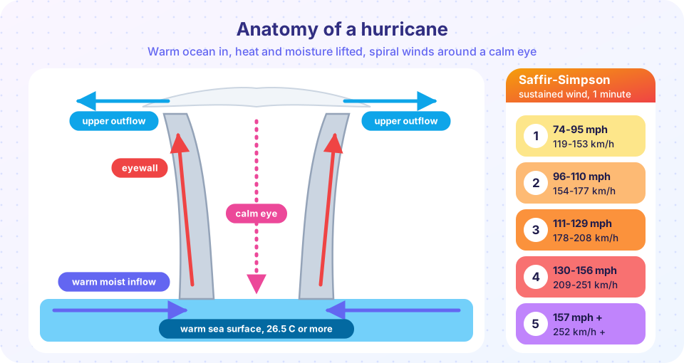
At the sea surface, strong winds evaporate water and carry heat and moisture into the air near the center. This warm, moist air spirals inward, rises through the thunderstorms of the eyewall, where the condensation of water vapor releases enormous latent heat, and flows outward near the tropopause in a cirrus shield. The heat released warms the column, which lowers the surface pressure, which strengthens the inward winds and the evaporation: a positive feedback. The air in the eye, on the other hand, sinks and warms, which keeps the center clear. Because the column is warm from top to bottom, the storm has a warm core, unlike a mid-latitude cyclone, which has fronts and a cold core aloft.
Think of the storm as a heat engine: it takes in heat at the warm ocean surface and discards it at the very cold top of the troposphere. The bigger the temperature difference, the more efficient the engine. This simple picture leads to the idea of a potential intensity: for a given sea temperature and upper-air temperature there is a theoretical maximum wind speed, and warmer seas raise the ceiling. Real storms usually fall short of it because of shear, dry air and internal cycles.
Structure
- Eye. Typically 30 to 65 km across, with light winds and often clear sky.
- Eyewall. A ring of towering clouds with the strongest winds and heaviest rain. Over days, an outer ring of thunderstorms can contract and replace the original eyewall. During that eyewall replacement cycle the storm often weakens and then re-intensifies as a larger storm.
- Spiral rainbands. Curved bands of showers and thunderstorms, which can spawn tornadoes, particularly on the right side of a storm as it makes landfall.
- Size. Radius of tropical-storm-force winds ranges from under 100 km to over 500 km.
Classification
Storms are named by their maximum sustained wind speed.
| Stage | Maximum sustained wind |
|---|---|
| Tropical depression | Below 34 knots (63 km/h) |
| Tropical storm (named) | 34 to 63 knots (63 to 118 km/h) |
| Hurricane / typhoon / cyclone | 64 knots (119 km/h) or more |
Hurricanes in the Atlantic and eastern Pacific are further rated on the Saffir–Simpson hurricane wind scale by 1-minute sustained winds:
| Category | Wind (mph) | Wind (km/h) |
|---|---|---|
| 1 | 74 to 95 | 119 to 153 |
| 2 | 96 to 110 | 154 to 177 |
| 3 | 111 to 129 | 178 to 208 |
| 4 | 130 to 156 | 209 to 251 |
| 5 | 157 or more | 252 or more |
Categories 3 and above are called major hurricanes. The scale is only about wind; it does not rate surge or rain, which can be extremely destructive even for weaker storms. Note also that agencies average winds over different time intervals (1 minute in the United States, 10 minutes for the WMO standard), so numbers from different countries are not directly comparable.
Press Run (or Ctrl + Enter) to see the result here.
Program input · what you'd type while the program runs
Type the answers before you press Run, one per line. Each time the program reads a line (with input()), it gets the next line from this box.
Hazards, ranked by danger
- Storm surge. Historically the leading cause of death. Wind drives water toward the coast and the low pressure lets the sea bulge upward. Over shallow, gently sloping coasts the water piles up higher, with the highest surge on the right of the track where the wind blows onshore. Hurricane Katrina (2005) produced a surge of more than 8 m at its peak, and the 1970 cyclone that struck Bangladesh (then East Pakistan) is thought to have killed several hundred thousand people, mostly by surge. Because surge arrives with the high tide and the waves on top, the water can reach inland for kilometers.
- Inland flooding from rain. A storm can drop 250 mm (10 inches) or more over a large area, and slow-moving storms drop much more. Rain flooding is now the leading cause of tropical cyclone deaths far from the coast.
- Wind. Wind damage rises steeply with speed. Because the force on a structure scales with the square of the wind speed, a Category 4 storm does far more damage than a Category 1.
- Tornadoes. Mostly weak, but they can add to the toll.
- Waves, rip currents and coastal erosion. These can affect coasts thousands of kilometers from the storm.
Rapid intensification, a gain of at least 30 knots (35 mph) in 24 hours, is the hardest part of the forecast. It tends to happen when a storm with a well-organized core passes over deep warm water in low shear. Track forecasts have improved dramatically over several decades, while intensity forecasts have improved more slowly. For this reason, official warnings tell people to prepare for the worst plausible outcome and not for the single number.
When a storm moves over land or over cool water, its heat supply is cut and it weakens, usually within a day or two. A decaying storm can still produce catastrophic rain far inland. A tropical cyclone that moves poleward may transform into a mid-latitude cyclone, an extratropical transition, with a cold core and fronts, and still produce hurricane-force winds.
Common misconceptions
"The category tells you how dangerous the storm is." It rates wind only; surge and rain often kill more people than wind. "The eye means the storm is over." The calm lasts minutes to an hour, and the winds return from the opposite direction and just as strong. "Hurricanes form from cold fronts." They are warm-core systems with no fronts. "You can always tell the landfall point from the center line." Hazards extend well to the sides of the track, and the forecast cone shows only the probable center position.
Check your understanding
Quick check · 5 questions
of 5 answered You scored / 5 · perfect!
-
1. What is the minimum sea surface temperature usually needed for tropical cyclone formation?
Roughly 26.5 C or more over a depth of about 50 m provides enough heat and moisture. -
2. Where does air sink in a mature tropical cyclone?
Sinking air warms and dries, creating the clear, calm eye. -
3. A storm has sustained winds of 100 mph. It is a
Category 2 covers 96 to 110 mph. -
4. Which hazard has historically caused the most tropical cyclone deaths?
Surge drowns people in coastal areas; inland rain flooding is now also a major killer. -
5. Why do tropical cyclones rarely form near the equator?
Coriolis force vanishes at the equator, so storms need to be at least about 5 degrees away.
Summary
- Tropical cyclones need warm ocean (26.5 C or more), low shear, moist air, enough Coriolis effect and a starting disturbance.
- They are warm-core heat engines that convert ocean heat into wind through the latent heat of condensation.
- Structure: eye, eyewall, spiral rainbands; the Saffir–Simpson scale rates sustained wind from Category 1 to 5.
- Storm surge and rain flooding often cause more harm than wind.
- Rapid intensification is the hardest part of the forecast, so warnings cover the worst plausible case.
Track your progress
Create a free account to tick off lessons and pick up where you left off on any device.
of Meteorology lessons completed