


















Lesson 18 of 54 · Moisture, Clouds and Precipitation
Lifting, cooling and atmospheric stability
Learn why rising air cools, how to find the lifting condensation level, the difference between dry and saturated lapse rates, and how stable, unstable and conditionally unstable air behave.
Clouds form when air rises. Rising air expands, cools, and sooner or later reaches its dew point, where its vapor condenses. But why does air rise in the first place, and why does a rising parcel sometimes keep going up to form a towering thundercloud while in other cases it stops after a few hundred meters or sinks back? The answer is stability: the comparison between a lifted parcel's temperature and the temperature of the surrounding air. This lesson builds on the parcel ideas from Chapter 2 to give you a practical way to predict whether air will rise.
What you will learn
- The four main ways air is forced to rise
- How to compute the lifting condensation level, where cloud base forms
- Why a saturated parcel cools more slowly than a dry one
- How to classify the atmosphere as stable, unstable or conditionally unstable
Key terms
- Lapse rate is the rate at which temperature decreases with height, in K per km.
- Environmental lapse rate (ELR) is the lapse rate of the surrounding air; the standard value is 6.5 K/km.
- Dry adiabatic lapse rate (DALR) is 9.8 K/km, the cooling rate of an unsaturated rising parcel.
- Saturated (moist) adiabatic lapse rate (SALR) is the cooling rate of a saturated parcel, typically 4 to 7 K/km.
- Lifting condensation level (LCL) is the height at which a lifted parcel becomes saturated; it marks the cloud base.
Four ways to make air rise
- Convection. Ground heated by the Sun warms the air above it. The warm parcel is less dense than its surroundings and rises on its own (a thermal). This builds the puffy cumulus clouds of a summer afternoon.
- Orographic lifting. Wind blowing against a mountain range is forced up the slope. This is why windward slopes are wet and leeward slopes dry (the rain shadow).
- Frontal lifting. At a front, cold dense air acts like a wedge, and warmer air is pushed up over it (Chapter 6).
- Convergence. Where winds flow together near the surface, air must go up, as in low-pressure systems and sea-breeze fronts.
In each case what happens next depends on stability.
Cooling rates
You already know that an unsaturated parcel cools at the dry adiabatic lapse rate of 9.8 K/km, because it expands as it rises into lower pressure. Once the parcel is cooled to its dew point it is saturated, and further lifting makes vapor condense. Condensation releases latent heat (2.5 MJ per kg of water), which partly offsets the expansion cooling. So a saturated parcel cools more slowly, at the saturated adiabatic lapse rate. The SALR is not a constant: it is about 4 K/km in warm, humid air near the surface in the tropics (a lot of vapor condensing) and approaches 9 K/km in very cold air (little vapor to condense). A typical value in the lower troposphere is 5 to 6 K/km, and we use 6 K/km in examples.
Finding the cloud base
Both the temperature and the dew point of a rising unsaturated parcel decrease, but at different rates: the temperature at 9.8 K/km and the dew point at about 1.8 K/km. The gap closes by about 8 K per kilometer, so the two meet after a height of (T − T_d) / 8 km, or
z_LCL ≈ 125 × (T − T_d) meters
Example: a summer afternoon at the surface has T = 28 °C and T_d = 16 °C. Then z_LCL = 125 × 12 = 1500 m. At that height, the temperature of the parcel is 28 − 9.8 × 1.5 = 13.3 °C, and the dew point is 16 − 1.8 × 1.5 = 13.3 °C, so they match, as they should. The cloud base will be at about 1.5 km. On a muggy day with T − T_d = 3 K, the cloud base is only 375 m above ground, which is why humid weather feels so low and gloomy. In a desert with T − T_d = 25 K, the LCL is above 3 km, and small thermals produce no clouds at all.
Stability
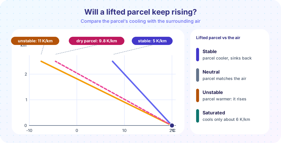
Compare a parcel with its environment. Suppose a parcel is lifted a little. If the parcel is colder (denser) than the surrounding air, gravity pushes it back, and the atmosphere is stable. If the parcel is warmer (lighter) it keeps rising, and the atmosphere is unstable. The test depends on the environmental lapse rate Γ compared with the parcel's:
| Condition | Meaning | Result |
|---|---|---|
| Γ < SALR | Environment cools more slowly than even a saturated parcel | Absolutely stable: lifted parcels always sink back |
| SALR < Γ < DALR | Between the two rates | Conditionally unstable: stable if dry, unstable if saturated |
| Γ > DALR | Environment cools faster than a dry parcel | Absolutely unstable: parcels accelerate upward |
Most of the real atmosphere is conditionally unstable, which means that it depends on whether the parcel is lifted far enough to be saturated. A parcel that is forced to rise past its LCL begins to cool more slowly, and it may at some height become warmer than the surroundings. That height is the level of free convection (LFC), above which the parcel rises by itself until it meets stable air, such as the tropopause or an inversion. The energy a parcel gains from being warmer than the environment is called convective available potential energy (CAPE), and it sets the strength of updrafts: large CAPE values (above 2000 J/kg) go with severe thunderstorms.
An inversion is a layer in which temperature rises with height. It is extremely stable, acts as a lid, and traps pollution and haze beneath it. Inversions form on clear calm nights near the ground (radiation inversions), in the subsiding air of high-pressure systems and at fronts.
Stability also decides what kind of cloud forms. In stable air, lifting produces flat layered clouds (stratus type) and drizzle. In unstable air, it produces towering cumulus and showers, and gusty winds and good visibility.
Press Run (or Ctrl + Enter) to see the result here.
Program input · what you'd type while the program runs
Type the answers before you press Run, one per line. Each time the program reads a line (with input()), it gets the next line from this box.
Press Run (or Ctrl + Enter) to see the console output here.
No output.
Putting it together
The path from a warm day to a thundercloud now follows from what you know. Sunlight heats the ground (Chapter 3). The warm ground heats the air above it, and a thermal rises. The thermal expands and cools at 9.8 K/km until it reaches the LCL, where condensation begins and a cloud base forms. Above this level, latent heat release slows the cooling. If the surroundings cool faster than that, which is typical of a conditionally unstable afternoon, the cloud keeps growing upward, and a cumulus cloud may become a cumulonimbus. If an inversion or warm air aloft stops it, the cloud flattens out and stays small. Meteorologists read stability from radiosonde soundings, plots of temperature and dew point against height, and use them every day to forecast showers and thunderstorms.
Common misconceptions
"Warm air rises, so it always keeps rising." A warm parcel rises only while it stays warmer than the air around it. It cools as it rises, and if the surroundings cool more slowly, it stops.
"Clouds form because the air is cold." Clouds form because rising air cools to its dew point, not because the air is cold at the start.
"Stable air means calm weather." Stable air suppresses rising motion, but strong winds, fog, drizzle and persistent overcast skies can occur.
Check your understanding
Quick check · 5 questions
of 5 answered You scored / 5 · perfect!
-
1. A parcel at the ground has T = 25 °C and T_d = 13 °C. Where is the cloud base?
z_LCL = 125 × (25 − 13) = 1500 m. -
2. Why does a saturated parcel cool more slowly than a dry one?
Each kilogram of vapor that condenses releases about 2.5 MJ, which offsets part of the expansion cooling. -
3. The environmental lapse rate is 4 K/km. The air is
4 K/km is below the saturated adiabatic rate (about 6 K/km), so a lifted parcel is colder than its surroundings either way. -
4. Which is NOT a way air is forced to rise?
Adiabatic warming happens when air sinks. The other three are lifting mechanisms. -
5. A layer where temperature increases with height is called
An inversion is very stable and acts like a lid that traps pollution and haze.
Summary
- Air is lifted by convection, mountains, fronts and convergence.
- Unsaturated parcels cool at 9.8 K/km; saturated parcels cool more slowly (about 4 to 7 K/km) because condensation releases heat.
- The cloud base is at the LCL, about 125 × (T − T_d) meters.
- Stability compares the parcel with the environment: stable (parcel colder), unstable (parcel warmer), or conditionally unstable (depends on saturation).
- Inversions are very stable lids; CAPE measures the energy available for convection.
Next: Clouds and their types
Track your progress
Create a free account to tick off lessons and pick up where you left off on any device.
of Meteorology lessons completed