


















Lesson 40 of 54 · Severe Weather and Climate Links
Chapter overview: Severe weather and climate links
Preview chapter 8 of the meteorology course: tornadoes, hurricanes, floods, heat waves, winter storms, El Nino and how climate change shifts the odds of extreme weather.
Most weather is mild. The sky clouds over, a shower passes, the wind picks up and drops. But now and then the atmosphere does something extreme: a funnel drops from a thunderstorm, a hurricane comes ashore, a river of rain stalls over a valley, a dome of heat sits over a continent for weeks, or a blizzard buries a city. These events cause most of the deaths and damage that weather does, and they get most of the attention. They also follow the same physical laws as everything else in this course. This chapter takes the ideas of the previous ones, pressure and fronts, instability and shear, forecasts and probabilities, and applies them to the most dangerous situations. It then steps back to ask how the slower rhythms of the climate system, from El Niño to global warming, change how often and how strongly such events occur.
The big picture
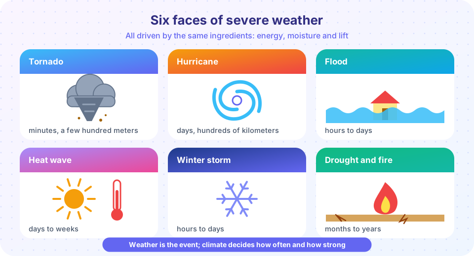
Severe weather can be sorted by scale. A tornado lasts minutes and is a few hundred meters wide. A severe thunderstorm lasts an hour and affects tens of kilometers. A hurricane lasts days and spans hundreds of kilometers. A heat wave or drought lasts weeks to years and covers a region. At each scale the same two questions help: where does the energy come from? and what organizes it?
For tornadoes and severe thunderstorms the energy is instability, measured by CAPE, and the organizing factor is wind shear. For hurricanes the energy is the warm ocean, and the organizing factor is the rotation of the Earth and low shear. For floods it is the moisture the air carries and how long a storm stays in one place. For heat waves and winter storms it is the structure of the large-scale flow: a persistent ridge, or a deep trough with a pool of cold air.
The climate link works through the same ingredients. A warmer atmosphere holds more water vapor, so heavy rain gets heavier. A warm ocean provides more fuel. Natural cycles such as El Niño move the storm tracks and rain belts around the globe from year to year. And the long-term warming trend raises the baseline for temperature extremes. Weather is the event; climate decides the odds.
Storms with rotation
Energy plus shear organizes violence.
Storms from the ocean
Long and slow hazards
Climate connections
What each lesson covers
- Supercells and tornadoes explains how shear organizes a thunderstorm into a rotating supercell, how tornadoes form, how they are rated and how warnings work.
- Tropical cyclones covers the ingredients, structure and life cycle of hurricanes and typhoons, the Saffir–Simpson scale and the hazards, especially storm surge.
- Floods, heat waves and winter storms treats three of the most deadly everyday extremes and the numbers behind them: return periods, heat index, wind chill and precipitation type.
- El Niño, La Niña and teleconnections shows how the tropical Pacific rearranges weather around the globe.
- Weather and climate change distinguishes weather from climate, explains why warming changes extremes, and introduces attribution science.
- Chapter review summarizes the chapter and tests your understanding.
A note on safety
This chapter describes hazards in a scientific way. It is not a safety manual. In real danger, follow the instructions of your national weather service and local emergency managers, and understand the difference between a watch (conditions are favorable for the hazard) and a warning (the hazard is happening or imminent).
Try it
The warning system in many countries uses color levels for increasing severity. This little demo shows the idea: choose a hazard level and see what each category typically means. It is a generic illustration, not an official scale of any particular country.
Check your understanding
Quick check · 3 questions
of 3 answered You scored / 3 · perfect!
-
1. What organizes a thunderstorm into a long-lived rotating supercell?
Strong change of wind with height tilts and rotates the updraft, giving a persistent mesocyclone. -
2. A weather 'watch' means
A watch calls for preparation; a warning says take action now. -
3. A warmer atmosphere can hold more water vapor by about
The Clausius-Clapeyron relation gives roughly 7 percent more saturation vapor per degree Celsius.
Summary
- Severe weather ranges from minutes and meters (tornadoes) to years and regions (drought).
- Each hazard has an energy source and an organizing factor: CAPE and shear, warm ocean and low shear, moisture and persistence.
- Natural cycles like El Niño and long-term warming shift where and how often extremes occur.
- Watches and warnings mean different things; follow official guidance in real danger.
Next: Supercells and tornadoes
Track your progress
Create a free account to tick off lessons and pick up where you left off on any device.
of Meteorology lessons completed