


















Lesson 31 of 54 · Air Masses, Fronts and Storms
Mid-latitude cyclones
Follow a mid-latitude cyclone from a wave on a front to occlusion and decay, learn how the jet stream feeds it, and calculate when a storm deepens explosively.
Most of the rain, snow and strong wind in the zone between the tropics and the poles comes from a single kind of weather system: the mid-latitude cyclone, also called an extratropical cyclone or a frontal low. These systems are huge, often 1,000 to 2,500 kilometers across, they take days to grow and decay, and they form chains that march from west to east along the storm tracks of the North Atlantic, the North Pacific and the Southern Ocean. If you live between 30° and 65° latitude, nearly every notable weather change you have experienced was caused by one. This lesson explains how they are born, how they develop, what they look like on a weather map, and why some of them intensify explosively.
What you will learn
- Describe the stages of the Norwegian cyclone model.
- Explain how upper-level divergence and the jet stream allow a surface low to deepen.
- Describe the weather in different parts of a cyclone.
- Use the Bergeron scale to recognize explosive deepening.
Key terms
Cyclogenesis is the formation and intensification of a cyclone. Warm sector is the region of warm air between the warm and cold fronts. Comma cloud is the satellite signature of a mature cyclone. Bomb cyclone (bombogenesis) is a storm whose central pressure falls at least 24 hPa in 24 hours at 60° latitude, scaled for other latitudes. Storm track is the preferred path of cyclones across an ocean.
The Norwegian model
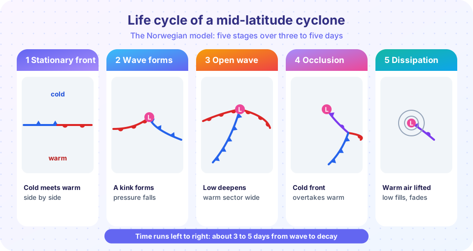
In the years just after the First World War, a group of Norwegian meteorologists at Bergen, led by Vilhelm Bjerknes and his son Jacob, together with Halvor Solberg and Tor Bergeron, proposed a picture of how cyclones develop on the polar front, the boundary between cold polar air and warm subtropical air. Their model has been refined, but the basic sequence still anchors every textbook and forecast.
- Stationary front. Cold air to the north and warm air to the south flow along the front in opposite directions. There is horizontal wind shear but no strong development.
- Incipient wave. A disturbance, often forced by the upper-level flow, bends the front into a wave. Pressure falls at the crest, and the circulation around the low begins to turn counterclockwise in the Northern Hemisphere.
- Open wave. The low deepens, the cold front advances southeast, and the warm front moves north. Between them lies the warm sector, a wedge of mild, humid air. This is the mature stage and the period of strongest development, usually 12 to 36 hours after the wave starts.
- Occlusion. The cold front moves faster than the warm front and begins to overtake it. The warm sector is lifted off the ground and contracts, forming an occluded front that spirals around the low center. The storm's central pressure reaches its minimum around this stage.
- Dissipation. With the warm air aloft and cold air everywhere at the surface, the temperature contrast that fed the storm is gone. The low fills, the winds weaken, and the remnant circulation drifts on or merges with another system.
From the first wave to the end typically takes three to seven days, and the whole system moves at roughly 30 to 50 km/h toward the east or northeast.
Weather around the low
Because the cyclone is a rotating system with fronts, the weather depends on where you stand.
| Location relative to the low | Typical weather |
|---|---|
| Ahead of the warm front (northeast of the low) | Thickening clouds, steady rain or snow; wind from the southeast |
| In the warm sector (south and southeast) | Warm, humid, partly cloudy; southwest wind; showers or thunderstorms possible |
| Along the cold front | Heavy showers, thunderstorms, gusty wind shift |
| Behind the cold front (west and northwest) | Clearing, cold, strong gusty northwesterly wind, then showers |
| North of the low (cold sector) | Cold, snow in winter, strong northerly wind |
A single storm can thus produce rain, a heat spike and a sharp cold snap within 24 hours at one location. On satellite images, a mature cyclone has a comma-shaped cloud: the head of the comma around the low center, and the tail along the cold front.
Why lows deepen: the upper-level connection
A surface low is a region where pressure at the ground is lower than around it. Pressure at the ground is the weight of the air column above, so for pressure to fall, air must leave the column. Near the surface, winds blow inward (convergence) because of friction, which adds mass. So the only way for a surface low to deepen is for the air aloft to flow out faster than air flows in below: divergence aloft must exceed convergence at the surface.
The jet stream provides the divergence. The upper-level flow is a wave pattern of troughs and ridges (Rossby waves). Just downstream (east) of an upper-level trough, the winds spread apart and speed up, so air is removed from the column. A surface low that lies beneath this region, with the upper trough to its west, is in the perfect spot to deepen. If the upper trough catches up with the surface low, the low stops deepening, which coincides with occlusion. This "tilt" of the storm system with height, westward as you go up, is characteristic of a growing cyclone.
Three airstreams carry the energy through the storm, often called conveyor belts: the warm conveyor belt, which carries warm humid air northward and upward ahead of the cold front and produces the main precipitation; the cold conveyor belt, which carries cold air westward under the warm front; and the dry intrusion, a stream of cold dry air from aloft that descends behind the cold front and produces the dry slot visible on satellite images.
Explosive cyclogenesis
Some storms deepen with astonishing speed. In 1980 Fred Sanders and John Gyakum proposed a definition: a bomb is a cyclone whose central pressure falls by at least 24 hPa in 24 hours at 60° latitude. At lower latitudes the required drop is smaller, because the Coriolis effect, and the size of the pressure change needed for the same wind change, scale with the sine of latitude. One "bergeron" is
24 hPa/24 h × sin φ / sin 60°
At 45° N, one bergeron is about 19.6 hPa in 24 hours. Bombs occur mostly over warm ocean currents such as the Gulf Stream and the Kuroshio in winter, where intense heat and moisture fluxes from the ocean add to the thermal contrast and to the latent heat release in the clouds. In a few extreme cases the pressure has fallen by around 50 hPa in a day, and the deepest non-tropical lows in the North Atlantic have reached central pressures near 915 hPa, comparable to a strong hurricane, though with a much larger size and a very different structure.
Press Run (or Ctrl + Enter) to see the result here.
Program input · what you'd type while the program runs
Type the answers before you press Run, one per line. Each time the program reads a line (with input()), it gets the next line from this box.
Common misconceptions
"A low pressure area means bad weather directly under the center." The heaviest weather often lies along the fronts and in the cloud shield ahead of the warm front, not at the center. "Cyclones are small tropical storms." Mid-latitude lows are far larger than hurricanes and get their energy from temperature contrasts, not warm oceans. "Fronts cause the low." The low and its fronts develop together, driven by the upper-level flow.
Check your understanding
Quick check · 5 questions
of 5 answered You scored / 5 · perfect!
-
1. In the open-wave stage, the warm sector is
The warm sector is the wedge of mild humid air south of the warm front and east of the cold front. -
2. For a surface low to deepen, which must happen?
Pressure falls only if air leaves the column. Upper-level divergence removes more mass than surface convergence adds. -
3. What defines a bomb cyclone at 60 degrees latitude?
The Sanders and Gyakum definition scales 24 hPa per 24 h by sin latitude over sin 60. -
4. Where does the heaviest, steadiest rain usually fall in a mature cyclone?
The warm conveyor belt rises over the warm front and occluded front and produces the broad rain shield. -
5. A cyclone stops deepening when
When the upper trough is overhead, the favorable divergence is gone and the storm is occluded and decays.
Summary
- Mid-latitude cyclones form as waves on the polar front and evolve through five stages over three to seven days.
- The weather varies with position: warm front rain, warm sector mildness, cold front showers, cold clearing behind.
- A surface low deepens when divergence aloft ahead of an upper trough exceeds surface convergence.
- Explosive deepening (a bomb) is at least 24 hPa in 24 hours at 60° latitude, scaled by sin φ at other latitudes.
- Occlusion marks the peak intensity, and the cyclone decays soon afterward.
Next: Thunderstorm development
Track your progress
Create a free account to tick off lessons and pick up where you left off on any device.
of Meteorology lessons completed