


















Lesson 28 of 54 · Air Masses, Fronts and Storms
Chapter overview: Air masses, fronts and storms
Preview chapter 6 of the meteorology course: how air masses form, how fronts separate them, how mid-latitude cyclones grow, and how thunderstorms develop.
Why does the weather change? In the mid-latitudes the answer is usually a simple one: a different kind of air has arrived. One day brings cold, dry, clear air from the interior of a continent. A few days later warm, humid air creeps in from the ocean to the south. The change between them is often sudden, and the narrow boundary that separates the two kinds of air is called a front. Along that boundary a swirl of low pressure forms, rain starts, and the week's weather changes. Understanding air masses, fronts and the storms that live on them is the key that unlocks most daily weather forecasting.
The big picture
Chapter 5 explained why air moves. This chapter asks what the moving air is like. A body of air that sits for days or weeks over a uniform surface, such as the snow fields of northern Canada or the warm waters of the Gulf of Mexico, takes on the temperature and moisture of that surface. We call it an air mass. When winds finally carry it away it keeps its character for a long time, bringing a bubble of "Canadian cold" or "tropical humidity" to places far away.
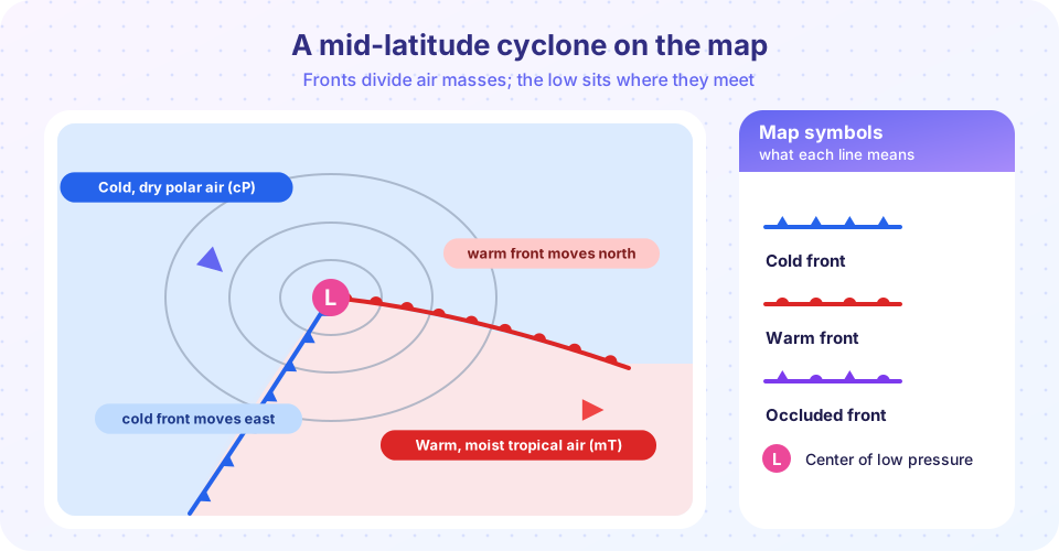
When two different air masses meet, they do not simply mix. They have different densities, so the lighter, warmer air rides up over the denser, colder air. The sloping boundary between them is the front, and the rising air along it forms clouds and rain. On the weather map a front is drawn as a colored line with symbols; you met the symbols in the picture above and will learn their meaning in lesson 2.
Where cold and warm air masses meet under the right conditions in the jet stream, a wave develops on the front and grows into a mid-latitude cyclone, the storm system that brings most of the rain, snow and wind to North America, Europe, East Asia and the southern oceans. Within and ahead of these systems, and also on hot afternoons with no front at all, the last topic of the chapter takes shape: the thunderstorm, a tower of cloud that can produce lightning, hail and flooding in an hour.
Meet the air masses
Source region sets the character.
Where they meet
A storm grows
Towers of cloud
What each lesson covers
- Air masses and source regions introduces the classification of air masses, the source regions of North America, Europe and Asia, and how air masses change as they travel.
- Cold fronts, warm fronts and occlusions takes fronts apart: their structure in cross-section, the sequence of weather as each passes, and how to recognize them in surface observations.
- Mid-latitude cyclones follows a storm through its life cycle, explains the role of the jet stream, and describes rapid deepening.
- Thunderstorm development covers the three ingredients, parcel theory and CAPE, the life cycle of a storm cell and the origin of lightning and thunder.
- Chapter review summarizes the chapter and tests you with ten questions.
Why this chapter matters
Almost every forecast discussion is written in the vocabulary of this chapter. "A cold front will cross the region on Thursday afternoon" is a statement about an air-mass boundary. "A deepening low will track across the Great Lakes" refers to a cyclone. "Afternoon thunderstorms in the warm sector" combines everything you will learn here. Later chapters on forecasting and severe weather assume that you can read those sentences easily.
Try it
This small quiz-style demo asks you to match a source region with the air mass it produces. It uses the standard two-letter codes that you will meet in the next lesson.
Check your understanding
Quick check · 3 questions
of 3 answered You scored / 3 · perfect!
-
1. What is a front?
A front is the sloping boundary where air masses of different temperature and humidity meet. -
2. An air mass takes its characteristics from
Air that sits over a uniform surface for days gradually acquires its temperature and moisture. -
3. Which storm system brings most mid-latitude rain and snow?
Mid-latitude cyclones form on fronts under the jet stream and carry weather across North America, Europe and Asia.
Summary
- Air masses are large bodies of air with uniform temperature and moisture, shaped by their source regions.
- Fronts are the boundaries between them, where warm air rises over cold air.
- Cyclones grow as waves on fronts, and thunderstorms need moisture, instability and lift.
- This chapter gives you the vocabulary of every weather forecast.
Track your progress
Create a free account to tick off lessons and pick up where you left off on any device.
of Meteorology lessons completed