


















Lesson 41 of 54 · Severe Weather and Climate Links
Supercells and tornadoes
Learn how wind shear and instability create rotating supercell thunderstorms, how tornadoes form and are rated on the Enhanced Fujita scale, and how warnings work.
An ordinary thunderstorm grows, rains, and dies within an hour. A supercell can last several hours, travel a hundred kilometers or more, and produce the very largest hail, the most damaging straight-line winds, and nearly all of the strongest tornadoes. What sets it apart is rotation: its main updraft turns slowly like a giant corkscrew, and that rotation organizes and sustains the storm. Whether a tornado results depends on delicate details near the ground that science can still only partly predict. This lesson explains what supercells need, how they are built, what happens when a tornado forms, how tornadoes are rated, and how forecasters and warning systems try to give people time to act.
What you will learn
- Explain why strong instability and wind shear together make supercells.
- Describe a supercell's structure and the radar signatures that identify it.
- Outline how a tornado forms and how it is rated on the EF scale.
- Distinguish a tornado watch from a warning and describe sensible precautions.
Key terms
Supercell is a thunderstorm with a persistent rotating updraft. Mesocyclone is the rotating updraft itself, a few kilometers wide. Wind shear is the change of wind speed or direction with height. Hook echo is a hook-shaped radar reflectivity signature near a supercell's rotation. Enhanced Fujita (EF) scale rates tornadoes from EF0 to EF5 by the damage they cause.
Ingredients: instability plus shear
Chapter 6 gave thunderstorms three ingredients: moisture, instability and lift. A supercell adds a fourth, a particular kind of wind shear. In a typical supercell setting in the plains of North America, the wind near the ground blows from the south or southeast at modest speed, and the wind at 5 to 6 km blows from the west or southwest at 20 to 30 m/s or more. That means the wind both speeds up and turns clockwise with height. The vector difference between the wind at 6 km and the wind at the surface, the bulk shear, of about 20 m/s (roughly 40 knots) or more is a typical threshold for supercells, along with CAPE of at least about 1,000 to 1,500 J/kg.
Why does shear matter? In a weakly sheared storm the downdraft falls right through the updraft and chokes it within an hour. In a sheared environment the updraft is tilted downwind, so the rain falls away to the side and the updraft can keep drawing warm air. That alone makes a storm last longer. The turning of the wind with height adds something special: horizontal vorticity. Imagine a rolling cylinder of air lying on its side along the ground, spun by the shear. When the rising air of the storm hits this roll, it tips the roll upward, and the horizontal rotation becomes vertical rotation. The updraft then rotates, and the result is a mesocyclone. This is why the direction of the shear matters as well as its size, and why forecasters compute a quantity called storm-relative helicity that measures how well the winds feed rotation into the updraft.
Press Run (or Ctrl + Enter) to see the result here.
Program input · what you'd type while the program runs
Type the answers before you press Run, one per line. Each time the program reads a line (with input()), it gets the next line from this box.
Anatomy of a supercell
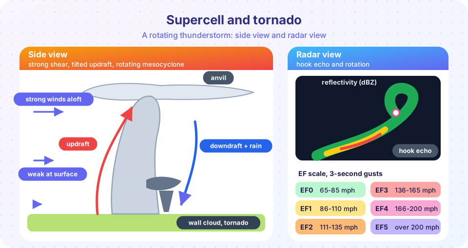
A mature supercell has several features that can be seen by eye and on radar.
- Updraft and anvil. A tilted updraft, often 20 to 40 m/s or more in strength, rises to the tropopause and spreads out in a large downwind anvil.
- Overshooting top. A dome that punches above the anvil into the stratosphere, marking an exceptionally strong updraft.
- Forward-flank downdraft. The main rain and hail core, on the front side of the storm.
- Rear-flank downdraft (RFD). A surge of dry, sinking air wrapping around the back side of the rotating updraft. It is crucial for tornado formation, because it can bring rotation down to the ground.
- Wall cloud. A lowered, rotating cloud base beneath the updraft, where the inflow rises into the storm. A wall cloud that visibly rotates is a classic warning sign.
- Hook echo. On radar, the rain and hail curl around the mesocyclone into a hook shape. Doppler velocity shows a tight pair of inbound and outbound winds, a couplet, at the same spot.
Supercell hail can be very large. The largest hailstone recorded in the United States, from Vivian, South Dakota, in 2010, was about 20 cm (8 inches) in diameter. Large hail needs a strong, long-lived updraft that holds ice particles aloft long enough for them to grow.
How a tornado forms
A tornado is a violently rotating column of air in contact with both the ground and a cloud base. Not all supercells make tornadoes, and some tornadoes form without supercells, for instance along squall lines or as short-lived "landspouts" under growing cumulus. In a supercell the working picture goes as follows.
- The mesocyclone strengthens and lowers its cloud base to form a wall cloud.
- The rear-flank downdraft descends and wraps around the rotation. Its air is cool and dense, and its arrival at the ground sets up a gust front under the rotating updraft.
- Under the right conditions, warm, moist, buoyant inflow is available near the surface, and it is drawn into the rotation and stretched upward. Stretching a spinning column makes it spin faster and narrower, like a skater pulling in her arms, and the circulation can intensify to tornado strength within a few minutes.
- A condensation funnel forms where the pressure inside is low enough for water vapor to condense. A tornado is a tornado whether or not the funnel reaches the ground: the damaging winds can be present before a visible funnel is complete, and a tornado can be invisible in rain.
Which supercells produce tornadoes, and why, remains an active research question. Factors that seem to matter include low cloud bases (high near-surface humidity) and strong low-level shear, but many storms with those traits do not produce tornadoes. This is one reason tornado warnings are issued with a lot of false alarms.
Rating tornadoes
Tornadoes cannot be measured directly by instruments: they are too small and too violent. They are rated afterwards by the damage they leave. The Enhanced Fujita (EF) scale, in use in the United States since 2007 and adopted in several other countries, assigns each tornado an EF0 to EF5 value from damage indicators such as the structure of a house or a tree stand. Each rating corresponds to an estimated three-second gust:
| Rating | Estimated wind (3-s gust) | Typical damage |
|---|---|---|
| EF0 | 65-85 mph (105-137 km/h) | Light: branches broken, shingles torn |
| EF1 | 86-110 mph (138-177 km/h) | Moderate: roofs damaged, mobile homes overturned |
| EF2 | 111-135 mph (178-217 km/h) | Considerable: roofs torn off, large trees snapped |
| EF3 | 136-165 mph (218-266 km/h) | Severe: walls lost from well-built houses |
| EF4 | 166-200 mph (267-322 km/h) | Devastating: well-built houses leveled |
| EF5 | over 200 mph (over 322 km/h) | Incredible: strong houses swept off foundations |
Most tornadoes are weak. In the United States, which has by far the most tornadoes of any country, with a long-term average on the order of 1,200 per year, the large majority are rated EF0 or EF1, and violent tornadoes (EF4 and EF5) make up only about one percent or fewer of the total, yet they cause a large share of the deaths. The deadliest tornado in United States history, the Tri-State tornado of 1925, traveled about 350 km across three states and killed nearly 700 people.
Press Run (or Ctrl + Enter) to see the console output here.
No output.
Forecasts, watches and warnings
Forecasters cannot say that a tornado will strike a specific house tomorrow, but they can say that conditions are favorable over a region. Days ahead, the tornado risk is shown as a probabilistic outlook. On the day, a tornado watch is issued for a large area when the ingredients, including instability, shear and moisture, are in place. When radar shows a strong rotation, or a spotter sees a tornado, a tornado warning is issued for a small area downstream of the storm, usually lasting 30 to 60 minutes. The average lead time of warnings in the United States has been in the range of about ten minutes, and some tornadoes occur with little or no lead time.
A simple tool for the first stage is the shear-and-CAPE chart. The html demo below combines the two numbers into a rough yes/no screen. It is only a teaching rule, because real forecasters use many more parameters.
When a tornado warning is issued, the standard advice from weather services is to move immediately to the lowest floor of a sturdy building, to an interior room away from windows, and to protect your head. Mobile homes and vehicles are not safe places. Fleeing by car from a tornado is dangerous unless you are in the open and far from the storm.
Common misconceptions
"Opening windows equalizes the pressure and saves the house." It does not; it wastes time and exposes you to debris, because damage comes from the wind. "Tornadoes avoid cities, rivers and hills." No landscape feature protects a place; cities are hit less often only because they cover little area. "A big funnel means a strong tornado." Width and intensity are loosely related; narrow tornadoes can be violent. "Every supercell produces a tornado." Only a minority do.
Check your understanding
Quick check · 5 questions
of 5 answered You scored / 5 · perfect!
-
1. Why does wind shear help storms last longer?
A tilted updraft separates the downdraft from the updraft, so the storm can keep drawing in warm air. -
2. A hook echo on radar is associated with
Rain and hail wrap around the mesocyclone, curling into a hook-shaped signature. -
3. The EF scale rates tornadoes by
Tornado winds are inferred from damage indicators; the rating is assigned after the fact. -
4. A tornado warning means
A watch is for favorable conditions; a warning is for an occurring or imminent tornado. -
5. What does stretching a rotating air column do?
Conservation of angular momentum means a narrower, stretched column rotates faster.
Summary
- Supercells need strong instability plus strong, turning wind shear, which gives a rotating updraft (mesocyclone).
- Key features are the tilted updraft, rear-flank downdraft, wall cloud and radar hook echo.
- Tornadoes form when rotation concentrates and stretches near the ground; only a minority of supercells make them.
- The EF scale rates tornadoes from EF0 to EF5 by damage, and most are weak.
- A watch means be ready; a warning means take shelter now.
Next: Tropical cyclones
Track your progress
Create a free account to tick off lessons and pick up where you left off on any device.
of Meteorology lessons completed