


















Lesson 14 of 49 · Seawater Chemistry and Physics
Temperature, Density and Ocean Layers
Learn how temperature and salinity set seawater density, why the ocean is layered into mixed layer, thermocline and deep water, and how T-S diagrams identify water masses.
The ocean is layered like a well-organized pantry: light things on top, heavy things below. Warm, fresh water floats; cold, salty water sinks. This is not a minor detail. The layers decide where nutrients get mixed up to sunlit waters, how heat is stored, where deep water forms and how currents run. A single graph of temperature against salinity can identify where a parcel of deep water came from, years after it left the surface.
This lesson shows how temperature and salinity control density, describes the three-layer structure of the ocean and introduces the temperature-salinity diagram, a favorite tool of oceanographers.
What you will learn
- How temperature, salinity and pressure determine density
- The mixed layer, thermocline and deep layer, and what makes each
- Why stratification makes the ocean stable and limits mixing
- How to read a T-S diagram and identify water masses
- How to compute simple stability numbers
Key terms
Mixed layer: the top layer, stirred by wind and waves, where temperature and salinity are nearly uniform.
Thermocline: the layer in which temperature drops rapidly with depth.
Pycnocline: the layer in which density increases rapidly with depth; usually the same depth as the thermocline.
Halocline: the layer in which salinity changes rapidly with depth.
Water mass: a large body of water with a characteristic temperature and salinity, formed at a particular place.
What sets the density
Density is mass per volume. For seawater at the surface it is about 1,027 kg/m³, and what matters for ocean dynamics is the small differences: oceanographers often quote density as σ ("sigma"), which is density minus 1,000 kg/m³, so a density of 1,027 is σ = 27.
Three things control it:
- Temperature. Warming expands water, making it lighter. The effect is stronger in warm water: about 0.2 kg/m³ per °C near 20 °C, but only about 0.05 kg/m³ per °C near 0 °C.
- Salinity. Each extra gram of salt per kilogram raises the density by about 0.78 kg/m³.
- Pressure. Compression raises density by roughly 4.5 kg/m³ per 1,000 m of depth, but this is a uniform effect that does not by itself cause water to sink or rise, so oceanographers remove it by comparing parcels at the same reference pressure (potential density).
Here are some values at the surface pressure for salinity 35:
| Temperature | Density |
|---|---|
| 0 °C | 1,028.1 kg/m³ |
| 10 °C | 1,026.95 kg/m³ |
| 20 °C | 1,024.8 kg/m³ |
| 30 °C | 1,021.7 kg/m³ |
For fresh water, density peaks at about 4 °C, so the coldest lake water is not at the bottom unless it is 4 °C. In seawater above a salinity of about 24.7, the temperature of maximum density is below the freezing point, so cooling always makes it denser. That is why polar seawater keeps sinking as it cools, forming the deep water that fills the ocean basins.
Three layers
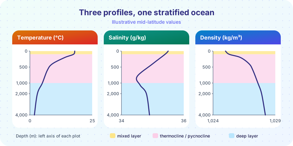
Average the open ocean in warm latitudes and you find three layers:
1. The mixed layer. Wind and waves stir the top tens to a couple of hundred meters, so temperature and salinity are almost uniform. In the tropics it is around 50 to 100 m thick; in winter at high latitudes it can be hundreds of meters thick, and in the deepest convection areas over 1,000 m.
2. The thermocline (and pycnocline). Below the mixed layer, temperature falls steeply, by several degrees over a few hundred meters (from about 100 to 1,000 m). Because density depends mainly on temperature in warm water, the pycnocline coincides with the thermocline. In middle latitudes there is a seasonal thermocline that forms in summer and is erased in winter, on top of a deeper permanent one. Near the poles there may be no thermocline at all.
3. The deep layer. Below about 1,000 m the water is cold, 2 to 4 °C, dense and changes slowly. It holds about 80% of the ocean's volume. Surprisingly, this water does not change by direct heating from above: it was formed at the surface in polar regions and sank.
Stratification and stability
Because the water is layered with light on top, it is stably stratified: if you push a parcel down, it is lighter than its surroundings and pops back up. Stable stratification means vertical mixing is hard. A measure is the buoyancy (Brunt-Väisälä) frequency:
N² = (g / ρ₀) × (Δρ / Δz)
where Δρ/Δz is the increase in density with depth.
Worked example. Across a pycnocline the density rises by 1.0 kg/m³ over 100 m, and ρ₀ ≈ 1,026 kg/m³:
N² = (9.81 / 1,026) × (1.0 / 100) = 9.6 × 10⁻⁵ s⁻², so N ≈ 0.0098 s⁻¹
A displaced parcel would oscillate with a period of 2π / N ≈ 640 s, about 11 minutes. Strong stratification (larger N) suppresses the vertical mixing that brings nutrients up to sunlit waters, which is why warm, stratified tropical oceans are often low in nutrients and clear blue.
T-S diagrams and water masses
A T-S diagram plots temperature (vertical) against salinity (horizontal) with curves of constant density drawn on it. A water parcel keeps its temperature and salinity almost unchanged after it leaves the surface, because heat and salt exchange only happens in the mixed layer or by slow mixing. So a deep water mass keeps the T-S "fingerprint" of the place where it formed. Typical examples:
- North Atlantic Deep Water (NADW): about 3 °C and salinity near 34.9, formed by winter cooling in the Labrador and Nordic Seas.
- Antarctic Bottom Water (AABW): very cold (about 0 °C or less) and salinity around 34.7, formed on the Antarctic shelves from brine rejection as sea ice freezes, the densest water in the ocean.
- Mediterranean outflow: warm (around 13 °C) and very salty (about 38), which spreads out in the North Atlantic around 1,000 m.
When two water masses meet and mix, the mixture lies on a straight line between them on the T-S diagram, so oceanographers can calculate how much of each was mixed.
Common misconceptions
"The whole ocean is warm in the tropics." Only the top few hundred meters are warm. At 1,000 m, even at the equator, the temperature is about 5 °C.
"Water sinks because of pressure." Pressure compresses all water; what makes a parcel sink is being denser than its surroundings at the same depth (after correcting for compression).
"Temperature alone sets density." Salinity matters as much: in the polar regions and near river mouths, salinity differences can dominate.
"Cold water is always at the bottom." In fresh lakes, the densest water is at 4 °C. In seawater, however, colder is denser all the way to freezing.
Try it
The first example draws a T-S diagram with density contours, computed with the standard equation of state for seawater at the surface pressure (UNESCO 1981). The positions of the labelled water masses are rounded typical values for illustration.
Press Run (or Ctrl + Enter) to see the result here.
Program input · what you'd type while the program runs
Type the answers before you press Run, one per line. Each time the program reads a line (with input()), it gets the next line from this box.
The second example is a stability calculator. It uses the same equation of state (at surface pressure, so it is meant for the upper ocean) to compare two layers and report whether the arrangement is stable.
Press Run (or Ctrl + Enter) to see the console output here.
No output.
Check your understanding
Quick check · 5 questions
of 5 answered You scored / 5 · perfect!
-
1. Which layer has nearly uniform temperature because wind and waves stir it?
The mixed layer is stirred by wind and waves so its properties are nearly uniform. -
2. What does a larger buoyancy frequency N mean?
N² is proportional to the density gradient; larger N means a more stable water column. -
3. Which water mass is the densest in the ocean?
AABW is formed near Antarctica by freezing and cooling, and sinks to the bottom. -
4. If salinity increases and temperature stays the same, what happens to density?
Each extra gram of salt per kilogram raises the density by about 0.78 kg/m³. -
5. Why does polar seawater keep sinking as it cools, unlike fresh lake water below 4 °C?
For salinity above about 24.7, cooling makes seawater denser all the way to its freezing point.
Summary
- Density rises as water gets colder, saltier or more compressed; potential density removes the effect of compression.
- The ocean is stably layered: a mixed layer, a thermocline/pycnocline and a deep layer that holds about 80% of the volume.
- Stratification limits vertical mixing;
N² = (g/ρ₀)(Δρ/Δz)measures it. - T-S diagrams fingerprint water masses such as NADW and AABW, which keep their properties after leaving the surface.
Track your progress
Create a free account to tick off lessons and pick up where you left off on any device.
of Oceanography lessons completed