


















Lesson 8 of 49 · The Ocean Basins
Continental Margins and Trenches
Explore the edge of the continents: shelf, slope and rise, passive versus active margins, submarine canyons and the deep trenches formed by subduction.
Where land meets deep sea, the seafloor does not drop off a cliff. It steps down in stages, from shelf to slope to rise, and the details depend on what the plates are doing underneath. Along the US East Coast, the descent is gentle and spread over hundreds of kilometers. Along the coast of Chile, it is abrupt and ends in a trench more than 8 km deep.
Understanding this difference is useful far beyond geology. It explains where the great fisheries are, why some coasts have devastating earthquakes and tsunamis and where oil, gas and submarine cables are found.
What you will learn
- The three parts of a continental margin and their typical sizes
- The difference between passive and active margins
- How submarine canyons and turbidity currents shape the slope
- How trenches and volcanic arcs form at subduction zones
- Why active margins produce the largest earthquakes
Key terms
Continental shelf: the shallow, gently sloping seafloor at the edge of a continent, usually ending at about 130 m depth.
Continental slope: the steeper descent from the shelf edge to the deep ocean floor.
Turbidity current: a fast, dense flow of sediment-laden water that runs downslope along the bottom.
Subduction zone: a convergent boundary where one plate sinks beneath another.
Volcanic arc: a chain of volcanoes above a subducting plate.
Shelf, slope and rise
The continental shelf
The shelf is a drowned part of the continent. Its average width is about 80 km, but it varies widely, from almost nothing off some mountainous coasts to more than 1,000 km off northern Siberia. Its outer edge, the shelf break, lies at an average depth of about 130 m, where the gradient suddenly steepens.
Why 130 m? During the last ice age, about 20,000 years ago, so much water was locked up in ice sheets that sea level was roughly 120 m lower than today. Rivers and waves were building and shaping the shelf edge at that lower level. When the ice melted, the sea rose and flooded the shelf. This is also why shelves have river valleys, ancient beaches and even drowned forests.
The shelf is also the most productive and valuable part of the ocean. Light reaches the bottom, rivers deliver nutrients, and most of the world's fish catch comes from shelf waters and nearby upwelling zones. Many oil and gas fields are also on shelves.
The continental slope
At the shelf break the bottom plunges down to the deep ocean floor, usually 3,000 to 4,000 m deep at the base. The average slope angle is only about 4 degrees, but that is much steeper than the shelf. It is the real geologic edge of the continent. Slopes are cut by submarine canyons, some as large as the Grand Canyon, carved by rivers during low sea level and by sediment flows.
The continental rise
At the base of the slope, sediment that has slid down builds a gentle apron called the continental rise. It is thickest where large rivers deliver lots of sediment, forming huge underwater fans, such as the Bengal Fan, the largest on Earth.
Worked example: how long is a slope?
If the seafloor drops from 130 m to 3,000 m with a slope of 4 degrees, how far horizontally does that take?
vertical drop = 3,000 − 130 = 2,870 m
horizontal distance = drop / tan(4°) = 2,870 / 0.0699 ≈ 41,000 m = 41 km
So even a "steep" 4-degree slope is a gentle ramp more than 40 km long. Real slopes vary from 1 to over 10 degrees. A slope of 4 degrees gains about 70 m of depth per kilometer.
Turbidity currents
Sediment piled up near the shelf edge is shaken loose by earthquakes or storms. It mixes with water into a dense slurry that flows down the slope like an underwater avalanche. These turbidity currents carve canyons, carry sand to the deep sea and deposit layered beds called turbidites. In 1929, an earthquake off Newfoundland (the Grand Banks event) triggered a turbidity current that broke a series of telegraph cables one after another across several hundred kilometers over many hours. The order and timing of the breaks is how scientists first realized such flows could travel at tens of kilometers per hour.
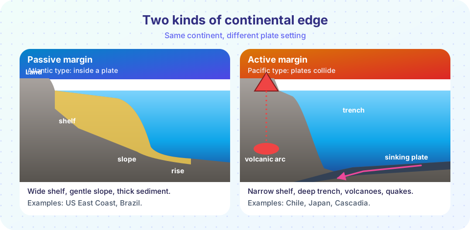
Passive and active margins
| Passive margin | Active margin | |
|---|---|---|
| Plate setting | Inside a plate, far from a boundary | At a convergent boundary |
| Shelf | Wide | Narrow or absent |
| Slope and rise | Gentle, thick sediment wedge | Steep, little rise |
| Trench | None | Yes, along the foot of the slope |
| Earthquakes and volcanoes | Rare | Frequent and large |
| Examples | US East Coast, Brazil, West Africa | Chile, Japan, the US Pacific Northwest |
Passive margins formed when a continent rifted apart. After the new ocean grew, the margin cooled and sank, and rivers piled thick sediment on top. Active margins are where a plate is sinking.
Trenches and subduction zones
When two plates converge, the denser one (older oceanic crust is cold and heavy) bends down and sinks into the mantle. The bend forms a deep, narrow valley, the trench. Trenches are the deepest places in the ocean: the Mariana Trench has Challenger Deep at about 10,900 m, and the Tonga, Kermadec and Philippine trenches also exceed 10,000 m.
The sinking plate drags down sediment and water. At about 100 km depth the water released from the slab lowers the melting point of the overlying mantle, and magma rises to build a volcanic arc: either a chain of islands (Japan, the Aleutians) if the upper plate is oceanic, or volcanoes on the coast (the Andes, the Cascades) if it is continental. Earthquakes occur along the contact between the two plates, with foci reaching deeper the farther you move from the trench (the Wadati-Benioff zone).
Subduction zones produce the biggest earthquakes, called megathrust earthquakes, because the two plates stick together for hundreds of years and then slip suddenly. The largest instrument-recorded earthquake, the 1960 Chile earthquake, had magnitude 9.5. The 2004 Sumatra-Andaman earthquake (magnitude about 9.1) and the 2011 Tohoku earthquake in Japan (about 9.1) also happened at subduction zones, and both triggered ocean-wide tsunamis. You will see how tsunamis travel in chapter 4.
Common misconceptions
"The shelf is part of the ocean basin." Geologically it is part of the continent. It is only covered by water because the sea level is currently high.
"Trenches are the deepest because the ocean floor is cracked." Trenches are bending zones where plates sink, not cracks in the floor.
"The Atlantic coast is calm because the ocean is calm." The Atlantic margin is quiet because it is a passive margin, far from plate boundaries. The Pacific rim has many earthquakes because it is lined with subduction zones.
Try it
The first example compares a passive and an active margin profile. They are illustrative profiles built from rounded values, not surveys.
Press Run (or Ctrl + Enter) to see the result here.
Program input · what you'd type while the program runs
Type the answers before you press Run, one per line. Each time the program reads a line (with input()), it gets the next line from this box.
The second example is a slope calculator. Give it a vertical drop and a slope angle and it returns the horizontal distance and the gradient.
Press Run (or Ctrl + Enter) to see the console output here.
No output.
Check your understanding
Quick check · 5 questions
of 5 answered You scored / 5 · perfect!
-
1. What is the average depth of the shelf break (the edge of the continental shelf)?
The shelf break averages about 130 m, close to the lowered sea level of the last ice age. -
2. Which is a feature of an active continental margin?
Active margins sit at convergent boundaries, with trenches, volcanic arcs and large earthquakes. -
3. A slope drops 1,400 m over a horizontal distance of 20 km. About what is its angle?
tan θ = 1,400 / 20,000 = 0.07, which gives θ of about 4 degrees. -
4. What is a turbidity current?
It is an underwater avalanche of sediment and water that carves canyons and builds fans. -
5. Which earthquake was the largest recorded by instruments?
The 1960 Chile earthquake had magnitude 9.5, the largest recorded.
Summary
- Continental margins step down from the shelf (to about 130 m) through the slope to the rise and the deep floor.
- Passive margins have wide shelves and thick sediment; active margins have trenches, volcanoes and big earthquakes.
- Turbidity currents carve canyons and build deep-sea fans.
- Trenches form where one plate subducts, and volcanic arcs form above the sinking slab.
Track your progress
Create a free account to tick off lessons and pick up where you left off on any device.
of Oceanography lessons completed