


















Lesson 27 of 49 · Ocean-Atmosphere Interaction
Hurricanes and Monsoons
See how warm ocean water fuels tropical cyclones, what the Saffir-Simpson scale measures, why storm surge is deadly, and how land-sea heating contrast drives the monsoon.
A mature hurricane releases heat at a rate comparable to many times the world's electrical generating capacity, and almost all of that energy was drawn out of the sea as water vapor. A monsoon, by contrast, is a gentle-looking seasonal turn of the wind that brings the rains on which billions of people depend. Both are expressions of the same ocean-atmosphere partnership you met in the last two lessons: warm sea water supplies moisture and heat, and the atmosphere turns it into wind and rain.
This lesson explains what a tropical cyclone needs, how it grows and decays, why the sea itself is a cause of the damage, and why the Asian monsoon reverses direction every year.
What you will learn
- The ingredients that let a tropical cyclone form and intensify
- How the Saffir-Simpson scale classifies hurricane winds
- Why the storm's heat engine depends on sea surface temperature, and how it cools the ocean beneath it
- What storm surge is and why it often causes more deaths than wind
- How the land-sea contrast produces the monsoon and its seasonal reversal
Key terms
Tropical cyclone: a rotating, organized storm system over warm tropical water. Called a hurricane in the Atlantic and eastern Pacific, a typhoon in the northwestern Pacific and simply a cyclone in the Indian Ocean and the South Pacific.
Eyewall: the ring of strongest winds and heaviest rain around the calm eye.
Wind shear: change of wind speed or direction with height; strong shear tears storms apart.
Storm surge: the rise of sea level above the normal tide caused by a storm's winds and low pressure.
Monsoon: a seasonal reversal of the prevailing wind, with a wet season and a dry season.
What a tropical cyclone needs
Meteorologists list several ingredients. All of them must be present:
- Warm water. A sea surface temperature of at least about 26.5 °C, and warm water extending down to roughly 50 m, so that the storm can stir up water without cooling the surface.
- Moist air through the lower and middle atmosphere.
- Low vertical wind shear, so that the storm's heat engine stays upright.
- A starting disturbance, such as a cluster of thunderstorms (in the Atlantic often a wave rolling off Africa).
- Enough Coriolis effect to spin the winds into a vortex. That is why storms do not form within about 5° of the equator.
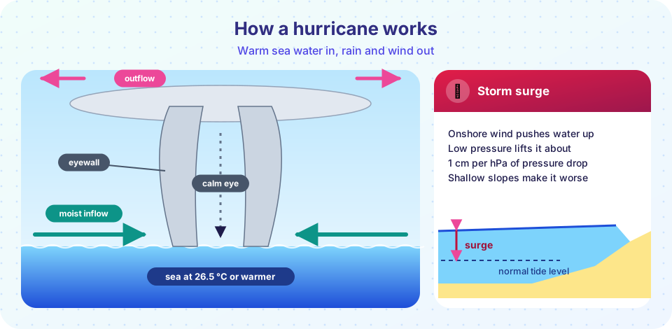
The first ingredient is the oceanographer's contribution. The energy engine works like this. Air flowing in at the sea surface picks up water vapor and some heat, through the bulk formulas of the last lesson. The air spirals inward, rises in the eyewall and condenses to cloud, releasing the latent heat. The heat warms the core of the storm, making the air there lighter and the surface pressure lower, which pulls in air faster. Faster winds raise the evaporation, supplying more fuel. This feedback keeps going until something limits it: cooler water, drier air, shear or land.
A thermodynamic ceiling
Because the storm's energy source is the difference between the warm sea and the cold upper air, there is a theoretical maximum potential intensity that rises with SST. It is a ceiling that real storms approach but rarely reach. Everything else being equal, a warmer sea allows a stronger storm, and more water vapor in the air means heavier rain. Rapid intensification, which means winds increasing by at least about 55 km/h (30 knots) in 24 hours, tends to happen over deep, very warm water.
The Saffir-Simpson scale
Hurricane strength is labeled by the Saffir-Simpson wind scale, based on the 1-minute sustained wind speed:
| Category | Winds (km/h) | Winds (mph) |
|---|---|---|
| 1 | 119 to 153 | 74 to 95 |
| 2 | 154 to 177 | 96 to 110 |
| 3 (major) | 178 to 208 | 111 to 129 |
| 4 (major) | 209 to 251 | 130 to 156 |
| 5 (major) | 252 or more | 157 or more |
Below 119 km/h a storm is a tropical storm (63 to 118 km/h) or a tropical depression. The scale measures wind only. The force of wind on a structure grows with the square of speed, so a Category 4 storm pushes on a wall with much more than twice the force of a Category 2 at the same location. Yet the scale does not measure storm surge or rainfall, which often cause most of the damage. Hurricane Harvey in 2017 did not set a wind record but stalled over Texas and dropped more than 1.5 meters of rain in places.
How the storm changes the ocean
The relationship runs both ways. The wind of a moving cyclone stirs the upper ocean. It drives strong near-surface currents that churn colder water up from below the mixed layer. The result is a cold wake: a trail of SST lower by a degree or several degrees behind the storm, visible on satellite maps for days. Cooler water lowers the evaporation under the storm, which limits it. This is why slow-moving storms can weaken themselves, and why deep warm water (a deep thermal layer, as found in the Gulf Stream and the Gulf of Mexico's Loop Current) matters so much for intensification.
Storm surge
Wind blowing onshore pushes water against the coast. The low pressure in the storm's center also lets the sea surface bulge upward by about 1 cm for each hectopascal of pressure drop (the "inverse barometer" effect). Together, these produce a storm surge that can reach several meters above the normal tide, driven inland as a wall of water. The surge is greatest where the sea floor slopes gently, which makes the shallow coast of the Bay of Bengal so dangerous: the 1970 Bhola cyclone struck what is now Bangladesh and killed an estimated 300,000 people or more, one of the deadliest natural disasters on record. Better forecasts, shelters and evacuation have cut death tolls in later storms dramatically.
The monsoon
The word comes from Arabic mawsim, "season". A monsoon is a seasonal reversal of wind. The classic case is the Indian Ocean and southern Asia.
In summer the land heats faster than the sea (land has a much lower heat capacity). Air above the Indian subcontinent warms, rises and creates a low-pressure area, so humid air flows in from the Indian Ocean as the southwest monsoon. This air is already loaded with moisture from the warm Arabian Sea. As it rises over the land and the Western Ghats and the Himalaya, it cools, condenses and pours out rain: roughly three quarters of India's annual rainfall arrives from June to September.
In winter the land cools below the sea temperature. Pressure is now higher over the land, and dry air flows out toward the ocean as the northeast monsoon. It is the same physical idea as a sea breeze, but with a six-month cycle and the size of a continent. Similar systems exist over West Africa, northern Australia and the Americas.
Monsoon strength varies from year to year. It is influenced by ocean temperatures, as in El Niño years, which tend to weaken it, and by the Indian Ocean Dipole, a see-saw of SST between the western and eastern Indian Ocean. Poor monsoons mean drought and food shortages for farmers; very heavy ones bring floods.
Common misconceptions
"A Category 1 storm is not dangerous." Wind is only one hazard. Storm surge, rainfall flooding and tornadoes can kill in weak storms.
"Hurricanes get their energy from the wind." Their energy comes from heat and moisture taken from the sea surface and released as the vapor condenses.
"The monsoon is a storm." It is a seasonal wind system. Individual storms (depressions) form within it, but the monsoon is the whole wet season.
"Warmer seas guarantee more hurricanes." Warmer seas raise the maximum possible intensity and the rainfall, but the number of storms depends on shear, moisture and other factors. Research suggests intense storms become a larger share of the total.
Try it
The first example is a hurricane classifier. Type a wind speed in km/h and it returns the Saffir-Simpson category and the relative force on a wall compared with a 100 km/h gale, using the rule that force grows with the square of speed.
Press Run (or Ctrl + Enter) to see the console output here.
No output.
The second example shows how the potential for evaporation grows with sea temperature. It uses the Magnus formula for the saturation vapor pressure of the sea, a fixed wind of 20 m/s and air at 85% relative humidity and one degree cooler than the water. It is a simple calculation, not a hurricane model.
Press Run (or Ctrl + Enter) to see the result here.
Program input · what you'd type while the program runs
Type the answers before you press Run, one per line. Each time the program reads a line (with input()), it gets the next line from this box.
Check your understanding
Quick check · 6 questions
of 6 answered You scored / 6 · perfect!
-
1. What is the usual minimum sea surface temperature for tropical cyclone formation?
Warm water, about 26.5 °C or more to a depth near 50 m, is needed to supply heat and moisture. -
2. A tropical cyclone has 1-minute sustained winds of 200 km/h. Its Saffir-Simpson category is...
Category 3 covers 178 to 208 km/h. -
3. Why do hurricanes not form within about 5° of the equator?
The Coriolis parameter f = 2Ω sin φ is nearly zero at the equator. -
4. The cold wake behind a hurricane is caused by...
Wind-driven mixing and upwelling bring cooler subsurface water to the surface along the storm track. -
5. Why does the Indian monsoon bring rain in summer?
Summer heating over land draws in humid air from the warm ocean, which rises and condenses. -
6. Which hazard is NOT measured by the Saffir-Simpson scale?
The scale is based on wind speed only; surge and rainfall need separate forecasts.
Summary
- Tropical cyclones draw their energy from warm sea water (about 26.5 °C or more) through evaporation and condensation.
- Low shear, moist air, a starting disturbance and the Coriolis effect are also needed.
- The Saffir-Simpson scale ranks winds only; storm surge and rainfall often cause the most harm.
- The storm cools the ocean beneath it, creating a cold wake that limits its own strength.
- The monsoon is a seasonal wind reversal driven by land-sea heating contrast.
Track your progress
Create a free account to tick off lessons and pick up where you left off on any device.
of Oceanography lessons completed