


















Lesson 6 of 49 · The Ocean Basins
Chapter 2 Overview: The Ocean Basins
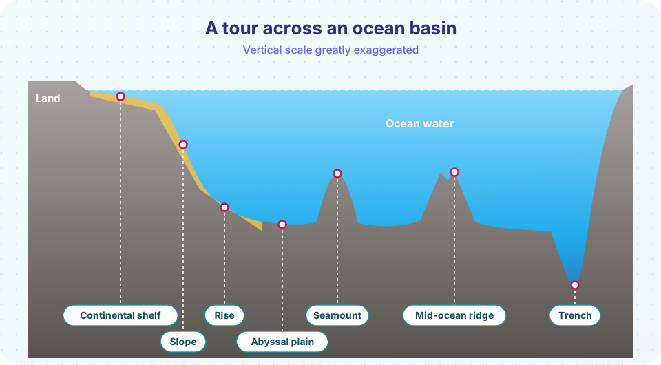
A guided tour of the ocean floor from continental shelf to trench, with the main features, typical depths and what each lesson in chapter 2 covers.
If you could drain the ocean, you would see a landscape as varied as any on land: broad flat plains, long mountain ranges, deep canyons, volcanoes that never reached the surface and cliffs taller than any on a continent. This chapter explains that landscape and, more importantly, why it looks the way it does.
The answer is a single idea, plate tectonics. The seafloor is not a static bowl. It is created at mid-ocean ridges, moves slowly sideways, collects sediment and is eventually destroyed at trenches. Almost every feature in this chapter is a stage in that cycle.
What you will learn
- The names and typical depths of the major seafloor features
- How the features connect into one cycle of birth, travel and destruction
- What each lesson in this chapter covers
- How to read a depth profile of the seafloor
Key terms
Bathymetry: the measurement and mapping of seafloor depth (the underwater version of topography).
Continental margin: the zone between the coast and the deep ocean floor, made up of the shelf, slope and rise.
Abyssal plain: the flat, sediment-covered floor of the deep ocean.
Mid-ocean ridge: a long undersea mountain chain where new seafloor is made.
Trench: a narrow, very deep valley where one plate sinks beneath another.
The features in order
Walking from the coast toward the middle of an ocean basin, you meet these features:
| Feature | Typical depth | Gradient | What it is |
|---|---|---|---|
| Continental shelf | 0 to about 130 m at its edge | very gentle | A drowned edge of the continent; average width about 80 km |
| Continental slope | about 130 to 3,000 m | steeper, around 4° on average | The real edge of the continent, often cut by canyons |
| Continental rise | about 3,000 to 4,000 m | gentle | A skirt of sediment at the foot of the slope |
| Abyssal plain | 3,000 to 6,000 m | almost flat | The flattest large places on Earth |
| Mid-ocean ridge | crest at about 2,500 m | rugged | The longest mountain chain on Earth, about 65,000 km |
| Seamount | rises 1,000 m or more | steep | An extinct or active underwater volcano |
| Trench | 6,000 to 11,000 m | steep walls | The deepest places in the ocean |
Notice that "the edge of the ocean" is not the coast. The shelf is geologically part of the continent, and the true boundary between continent and ocean basin is at the slope.
One cycle, five steps
The chapter's lessons are the steps of a single cycle:
- Birth. At a mid-ocean ridge, plates pull apart and magma rises, cools and forms new oceanic crust.
- Travel. The new crust moves away from the ridge at a few centimeters per year, cooling and sinking as it ages.
- Burial. Sediment slowly settles on it, thin near the ridge and thicker near continents.
- Decoration. Volcanoes grow on it, some above a stationary hotspot, forming chains of seamounts and islands.
- Death. At a trench, the old crust bends down and sinks into the mantle, to be recycled.
Born at a ridge
Aging on the move
Decorated by volcanoes
Destroyed at trenches
What each lesson covers
- Seafloor Spreading and Plate Tectonics: the evidence, from magnetic stripes to the age of the crust, and how plates move.
- Continental Margins and Trenches: why some coasts are gentle and others violent, with shelf, slope, rise and subduction.
- Ridges, Hotspots and Seamounts: the volcanic structures of the deep sea and the island chains they make.
- Seafloor Sediments: where the mud comes from, how fast it builds up and what cores tell us about the past.
- Chapter 2 Review: a picture, a table and a ten-question quiz.
Common misconceptions
"The ocean floor is a flat bowl." It has more variety than the continents: ridges, trenches, canyons, plains and seamounts.
"The oldest rocks on Earth are on the seafloor." The opposite: the oldest oceanic crust is only about 180 to 200 million years old, because it is recycled at trenches. Continental rocks can be billions of years old.
"The deepest part of the ocean is in the middle." Deep trenches lie near continental margins and island arcs. The middle of an ocean often has a mountain range, the mid-ocean ridge.
Try it
The first example plots a simple depth profile across an ocean basin. Edit the points and see how the landscape changes. The profile is an illustration, not a measured transect.
Press Run (or Ctrl + Enter) to see the result here.
Program input · what you'd type while the program runs
Type the answers before you press Run, one per line. Each time the program reads a line (with input()), it gets the next line from this box.
The second example is a quick feature identifier. Give it a depth and a slope and it suggests which feature you might be looking at. It is a teaching rule of thumb, not a classification used by surveyors.
Press Run (or Ctrl + Enter) to see the console output here.
No output.
Check your understanding
Quick check · 4 questions
of 4 answered You scored / 4 · perfect!
-
1. Which is the true edge of a continent in geological terms?
The shelf is a drowned part of the continent; the slope marks the transition to the deep ocean basin. -
2. Where is new oceanic crust created?
At ridges, plates pull apart and rising magma forms new crust. -
3. Roughly how deep are the abyssal plains?
Abyssal plains cover much of the ocean floor at depths of about 3,000 to 6,000 m. -
4. Why is the oldest oceanic crust only about 180 to 200 million years old?
Old oceanic crust sinks at subduction zones, so it does not survive long compared with continents.
Summary
- The seafloor has a varied landscape: shelf, slope, rise, abyssal plain, ridge, seamounts and trenches.
- These features are stages in a cycle: birth at ridges, travel, burial, volcanic decoration and destruction at trenches.
- The shelf is part of the continent; the slope is the true edge.
- The following lessons explain each stage and the sediments that cover them.
Track your progress
Create a free account to tick off lessons and pick up where you left off on any device.
of Oceanography lessons completed