


















Lesson 21 of 49 · Waves, Tides and Currents
Surface Currents and Gyres
Learn how wind, Earth's rotation and the continents create surface currents and gyres: Coriolis effect, Ekman transport, western boundary currents like the Gulf Stream, and upwelling.
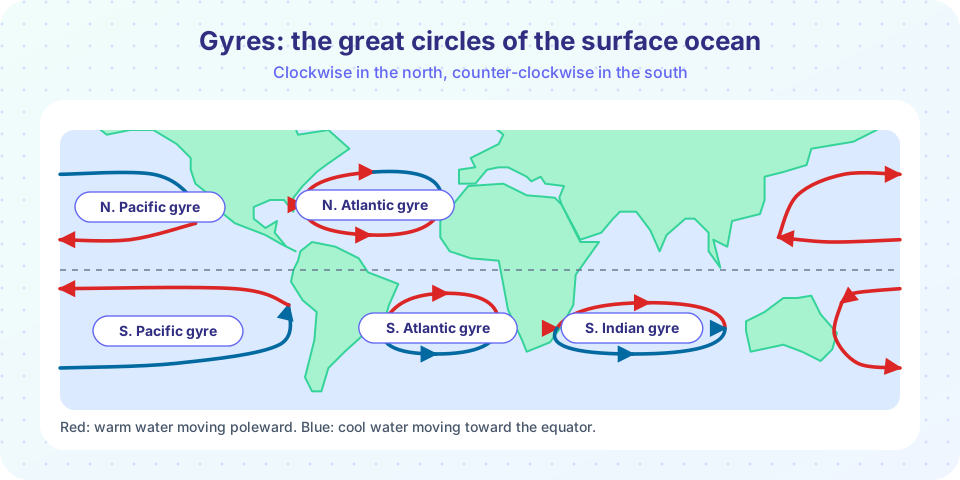
If you drop a bottle into the Atlantic off the coast of Africa, it will probably not drift straight across to America. It will curve: first west along the tropics, then north with the Gulf Stream, then east across the North Atlantic and finally south again along Europe and Africa. This circuit, repeated in every ocean basin, is a gyre. It is one of the most regular large-scale patterns in nature, and it is built from just three ingredients: wind, the rotation of the Earth and the shape of the continents.
This lesson takes you from the winds above to the currents below. You will meet the Coriolis effect, work out how much water the wind pushes with Ekman transport, see why the Gulf Stream is narrow and fast and learn how currents bring cold, nutrient-rich water to the surface.
What you will learn
- How the global wind belts push on the ocean surface
- What the Coriolis effect is and how large it is
- What Ekman transport and the Ekman spiral are
- Why gyres have strong, narrow western boundary currents
- How wind-driven upwelling works and why it matters
Key terms
Wind stress: the horizontal force per unit area that wind exerts on the sea surface, in N/m².
Coriolis parameter (f): 2 Ω sin(latitude); the strength of Earth's rotation effect at a given latitude.
Ekman transport: the net movement of the wind-driven surface layer, at 90° to the right of the wind in the Northern Hemisphere (left in the Southern).
Western boundary current: a narrow, fast current on the western edge of an ocean basin, like the Gulf Stream.
Upwelling: the rise of deeper, colder, nutrient-rich water to the surface.
Sverdrup (Sv): a unit of ocean flow, 1 million m³ per second.
The wind belts
Earth's atmosphere circulates in bands. Between the equator and about 30° latitude the trade winds blow from the east (toward the west). Between about 30° and 60° the westerlies blow from the west. Near the poles the polar easterlies blow from the east. Wind drags on the sea surface, and as a rule of thumb the surface water moves at about 2 to 3% of the wind speed, so a 10 m/s wind drives a surface drift of 0.2 to 0.3 m/s.
The force on the sea is the wind stress. A standard approximation is
τ = ρ_air × C_D × U²
with air density ρ_air ≈ 1.2 kg/m³, drag coefficient C_D ≈ 1.3 × 10⁻³ and wind speed U. For U = 10 m/s, τ = 1.2 × 1.3 × 10⁻³ × 100 ≈ 0.16 N/m². Because stress grows with U², a 20 m/s storm wind produces four times the stress.
The Coriolis effect
Earth rotates once a day. On a rotating sphere, anything that moves freely appears to be deflected: to the right of its motion in the Northern Hemisphere and to the left in the Southern Hemisphere. The strength is measured by the Coriolis parameter:
f = 2 Ω sin φ
where Ω = 7.292 × 10⁻⁵ rad/s is Earth's rotation rate and φ is the latitude. At 45° latitude f = 2 × 7.292 × 10⁻⁵ × 0.707 = 1.03 × 10⁻⁴ s⁻¹. At the equator f = 0 (no deflection) and at the poles it is largest. The effect is minute for small, fast things like a thrown ball, but for slow, large-scale ocean flows that last days or longer it dominates.
Ekman transport
In 1893 the Norwegian explorer Fridtjof Nansen noticed during the Fram expedition that sea ice drifted not downwind but about 20 to 40 degrees to the right of it. His student Vagn Walfrid Ekman worked out why. Wind pushes the surface water. Coriolis deflects it. Each deeper layer is dragged by the one above and deflected again, so the current turns more and weakens with depth, forming the Ekman spiral. The surface current is about 45° to the right of the wind in the Northern Hemisphere, and the velocity vanishes at a depth of about 50 to 100 m, where the Ekman layer ends.
Adding up the whole layer, the net transport is at 90° to the right of the wind (in the Northern Hemisphere). Its magnitude per meter of width is
M = τ / (ρ f)
Worked example. At 40° N (f = 9.4 × 10⁻⁵ s⁻¹) with τ = 0.16 N/m² and ρ = 1,027 kg/m³:
M = 0.16 / (1,027 × 9.4 × 10⁻⁵) = 1.66 m²/s
So the layer carries 1.66 m³ of water each second across each meter of line perpendicular to the transport. Over 1,000 km of coastline (10⁶ m), that is 1.66 × 10⁶ m³/s = 1.66 Sv.
Coastal upwelling
Suppose the wind blows south along a coast on the eastern edge of a Northern Hemisphere ocean, such as California. Ekman transport is 90° to the right of the wind, which is offshore. The surface water pulled away from the coast is replaced by cold, nutrient-rich water rising from 50 to 200 m below. This is coastal upwelling. The great eastern-boundary upwelling systems (California, Peru-Humboldt, Canary, Benguela) cover only a small fraction of the ocean area but supply a large share of the world's fish catch, because the upwelled nutrients fertilize the plankton (chapter 6).
Gyres
Now combine these ingredients. In each subtropical band the trade winds blow westward on the equatorial side and the westerlies blow eastward on the poleward side. The Ekman transport in both is toward the middle of the gyre, piling up water into a gentle dome, about a meter high, in the center. Water tends to flow downhill, but Coriolis deflects it, so instead of flowing out it circles around the dome. This balance, called geostrophic flow, makes the water circulate clockwise around a high in the Northern Hemisphere and counter-clockwise in the Southern. Land blocks the circuit on each side and turns the water around.
Western intensification
The gyre is not symmetric. On the western side the current is narrow (50 to 100 km), deep (a kilometer or more), fast (1 to 2 m/s or more) and warm: the Gulf Stream (North Atlantic), Kuroshio (North Pacific), Brazil Current, East Australian Current and Agulhas Current. On the eastern side the flow is broad, shallow, slow (a few cm/s to 0.1 m/s) and cool: California, Canary, Peru-Humboldt and Benguela currents. Henry Stommel showed in 1948 that this asymmetry follows from the variation of the Coriolis parameter with latitude. The effect is strong enough to squeeze the return flow into a thin jet on the west.
Worked example. The Gulf Stream in the Florida Straits carries about 30 Sv through a section 80 km wide and, say, 700 m deep on average:
speed = Q / A = 30 × 10⁶ / (80 × 10³ × 700) = 0.54 m/s
The fastest water at the surface is much quicker, up to about 2 m/s. Further downstream the Gulf Stream gathers more water and reaches 100 Sv or more, which dwarfs all the world's rivers combined (about 1 Sv).
Along the Gulf Stream, a large amount of heat is carried north, the order of a petawatt, helping to keep winters in northwestern Europe milder than at the same latitude elsewhere (though the westerly winds that carry heat from the ocean to the land also matter). Around Antarctica, with no continents in the way, the Antarctic Circumpolar Current flows eastward and is the largest current on Earth, carrying roughly 130 to 150 Sv.
Gyres also gather floating material. Plastic debris accumulates in the calm centers of the subtropical gyres, creating the so-called garbage patches, which are more like a diffuse soup of fragments than islands of trash.
Eddies
Currents are unstable. The Gulf Stream meanders, and loops pinch off as rings or eddies, 100 to 300 km across, that drift for months carrying warm or cold water of their origin. These mesoscale eddies contain most of the ocean's kinetic energy and mix heat and nutrients.
Common misconceptions
"Currents flow straight downwind." The net water transport is at 90° to the wind (Ekman), and the surface current is about 45° to the wind direction.
"The Coriolis effect decides which way your toilet drains." The effect is tiny at that scale. It matters for processes of hundreds of kilometers and days or longer.
"The Gulf Stream is why Europe is warm, full stop." It helps, but the atmosphere does most of the heat transport, and Europe's mildness is also due to westerly winds and the ocean's heat storage.
"The ocean garbage patch is an island you can walk on." It is a widely scattered mix of fragments, mostly small, spread over a huge area.
Try it
The first example is an interactive Ekman explorer. Set the wind direction and choose a hemisphere. The arrows show the wind, the surface current (45° from the wind) and the net transport (90° from the wind).
The second example computes the Coriolis parameter and Ekman transport as functions of latitude, and shows how a coastal wind creates upwelling. The wind stress is a rounded typical value.
Press Run (or Ctrl + Enter) to see the result here.
Program input · what you'd type while the program runs
Type the answers before you press Run, one per line. Each time the program reads a line (with input()), it gets the next line from this box.
Check your understanding
Quick check · 5 questions
of 5 answered You scored / 5 · perfect!
-
1. In which direction is the net Ekman transport in the Northern Hemisphere, relative to the wind?
Coriolis deflection integrated over the Ekman layer gives net transport 90° to the right in the north. -
2. Which way do subtropical gyres circulate in the Southern Hemisphere?
They turn clockwise in the north and counter-clockwise in the south. -
3. What best describes western boundary currents like the Gulf Stream?
Western intensification makes them narrow (50 to 100 km), deep and fast (1 to 2 m/s). -
4. Wind blows south along the coast of California. What does Ekman transport do to the surface water?
Transport is 90° to the right of a southward wind, i.e. westward (offshore); upwelling replaces it. -
5. A current carries 30 Sv through a section 60 km wide and 500 m deep. What is the mean speed?
Area = 60,000 × 500 = 3 × 10⁷ m²; speed = 3 × 10⁷ / 3 × 10⁷ = 1 m/s.
Summary
- Trade winds, westerlies and polar easterlies push on the surface; wind stress is
τ = ρ_air C_D U². - Coriolis (
f = 2Ω sin φ) deflects flow right in the north and left in the south; net Ekman transport is 90° to the wind,M = τ/(ρ f). - Gyres turn clockwise in the Northern Hemisphere and counter-clockwise in the Southern; western boundary currents are narrow and fast.
- Wind along a coast creates upwelling, bringing nutrients to the surface.
Next: Deep Ocean Circulation
Track your progress
Create a free account to tick off lessons and pick up where you left off on any device.
of Oceanography lessons completed