


















Lesson 4 of 49 · Getting Started
A Short History of Ocean Exploration
Follow ocean exploration from Polynesian wayfinders and HMS Challenger to sonar, submersibles, hydrothermal vents, satellites and the Argo float network.
For most of human history, the sea was a road, not a subject of study. People crossed it, fished in it and feared it, but they did not ask what was under it. Oceanography as a science is young: the first expedition devoted entirely to studying the deep sea sailed less than 150 years ago, and the first humans reached the deepest trench only in 1960. Each advance came from a new tool, and each tool changed what we could ask.
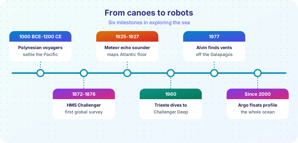
This lesson follows six milestones, each tied to an instrument or method. Along the way you will see a pattern that continues today: new technology reveals surprises, and the surprises raise better questions.
What you will learn
- How early navigators and naturalists built knowledge of the sea
- Why the Challenger expedition (1872 to 1876) founded modern oceanography
- How sonar, submersibles and satellites each opened a new window
- What the discovery of hydrothermal vents changed
- How today's observing systems, such as Argo, work together
Key terms
Sounding: measuring the depth of the water, first with a weighted line and later with sound.
Echo sounder: an instrument that sends a pulse of sound down and times its echo from the seafloor to find the depth.
Submersible: a small underwater vehicle that carries people or instruments to depth.
Hydrothermal vent: a place on the seafloor where hot, mineral-rich water pours out.
Argo float: a robotic drifter that dives to about 2,000 m, rises to the surface and sends its temperature and salinity profile by satellite.
Wayfinders and early charts
Long before written science, Polynesian navigators crossed thousands of kilometers of open Pacific, reaching islands such as Hawaii and Aotearoa (New Zealand). They steered by stars, the direction of ocean swells, the flight of birds and the color of clouds over distant land. Their knowledge was oral and practical, and it contained real physical oceanography: swells keep their direction for long distances and bend around islands in recognizable patterns. Settlement of the remote Pacific happened over roughly the last three thousand years.
Elsewhere, sailors and merchants kept notes about winds and coasts. In 1769 to 1770, Benjamin Franklin, working from the knowledge of ship captains, published a chart of a warm current off the American coast that shortened voyages, the Gulf Stream. In the 1850s, US naval officer Matthew Fontaine Maury collected thousands of ship logs and used them to chart winds and currents; his 1855 book The Physical Geography of the Sea is often called the first oceanography textbook. At the same time, laying telegraph cables across the Atlantic pushed engineers to measure what the seafloor looked like.
HMS Challenger (1872 to 1876)
The turning point was the Challenger expedition. The British Royal Navy ship HMS Challenger, converted to a floating laboratory, sailed about 127,000 km (nearly 69,000 nautical miles) around the world. The scientific team was led by Charles Wyville Thomson, with the ship commanded by Captain George Nares. At stations across the Atlantic, Pacific and Southern Oceans the crew:
- measured depth with weighted lines,
- measured temperature at different depths,
- dragged dredges and trawls along the bottom to collect animals and sediment,
- analyzed water samples,
- and recorded currents.
The results shaped the field. The team found thousands of new species, including animals living at depths where people had believed life could not exist. They showed that deep seafloor was covered in fine sediment, discovered the manganese nodules that litter some seafloors and located a deep part of the Mariana Trench, which the Challenger Deep is still named for. The final report ran to about fifty volumes and took twenty years to publish. The expedition proved that the deep sea was worth studying as a place, not just as a hazard.
Sound: the echo sounder and the shape of the floor
Measuring depth with a weighted line was slow: a single deep sounding could take hours. After the First World War, ships began using echo sounding. A pulse of sound is sent down and the time for the echo to return gives the depth:
depth = (speed of sound × round-trip time) / 2
Sound travels at about 1,500 m/s in seawater, so an echo from 3,000 m returns after about 4 seconds. The German research ship Meteor used echo sounders on a long Atlantic expedition (1925 to 1927) and collected tens of thousands of soundings, showing that the Atlantic floor is not a flat plain but has a vast mountain range down the middle.
Later, Marie Tharp and Bruce Heezen turned sounding records into maps of the seafloor in the 1950s. Tharp's maps revealed a rift valley along the Mid-Atlantic Ridge, an important clue that led to plate tectonics (chapter 2).
Crewed dives and the discovery of vents
In 1960, the bathyscaphe Trieste carried Jacques Piccard and Don Walsh to the bottom of Challenger Deep, about 10,900 m down, a dive that has been repeated by only a few people since, including film director James Cameron in 2012 and explorer Victor Vescovo in 2019.
A more consequential tool was the small research submersible Alvin, first operated in 1964. In 1977, Alvin scientists exploring the Galápagos Rift found something that was not expected: hot water seeping from cracks in the seafloor and thriving communities of giant tube worms, clams and bacteria living around it, in complete darkness. These hydrothermal vent communities get their energy from chemicals, not sunlight. The discovery changed biology and raised new questions about how life began on Earth and whether it might exist elsewhere.
Satellites and robotic floats
From space, satellites such as Seasat (1978) and TOPEX/Poseidon (1992) measure the height of the sea surface to within centimeters, revealing currents, tides, eddies and the slow rise of sea level. Other satellites measure sea-surface temperature, wind and the color of the water, which shows where phytoplankton are abundant.
Beneath the surface, the Argo program (begun around 2000) uses autonomous floats. Each one drifts at about 1,000 m, dives to about 2,000 m, rises to the surface while measuring temperature and salinity, sends its data by satellite and repeats the cycle about every 10 days. By late 2007 the network reached its target of about 3,000 active floats, and it has kept roughly that many since. Argo provides the first continuous, global look at the ocean interior and is the main source for knowing how much heat the ocean is storing.
Today the largest gap is detailed seafloor maps. The Seabed 2030 project, launched in 2017, aims to map the entire seafloor at useful resolution by 2030.
Common misconceptions
"People explored the ocean widely in the 1800s, so we know it well." The first systematic deep-sea expedition was Challenger in the 1870s. Even now, only a small fraction of the seafloor has been mapped at high resolution, and the deep sea is still the least explored part of the planet.
"Hydrothermal vents were predicted by theory." They were found by surprise in 1977. (Scientists had predicted hot water from mid-ocean ridges, but not whole ecosystems.)
"Ships can do everything." Ships are essential, but robots, satellites and moorings now collect far more data than any single expedition, and they work all year round.
Try it
The first example is an interactive timeline. Move the slider to a year and see which tools and discoveries already existed.
The second example compares how many deep profiles the Challenger expedition and the Argo network collect. The Argo figure follows from the cycle length; the Challenger figure is rounded to about 360 stations. Both are approximate and meant to show the scale of the change.
Press Run (or Ctrl + Enter) to see the result here.
Program input · what you'd type while the program runs
Type the answers before you press Run, one per line. Each time the program reads a line (with input()), it gets the next line from this box.
Check your understanding
Quick check · 5 questions
of 5 answered You scored / 5 · perfect!
-
1. Which expedition is considered the foundation of modern oceanography?
Challenger was the first expedition devoted to studying the deep sea around the world, and its reports shaped the new science. -
2. How does an echo sounder find the depth?
depth = (speed of sound × round-trip time) / 2, with sound at about 1,500 m/s in seawater. -
3. What was surprising about the 1977 discovery at the Galápagos Rift?
Hydrothermal vent communities depend on chemosynthesis, not sunlight, which changed biology. -
4. What does an Argo float do?
Argo floats drift, dive, rise, send data by satellite and repeat about every 10 days. -
5. If an echo returns 4.0 seconds after a pulse and sound travels 1,500 m/s, what is the depth?
depth = 1,500 × 4.0 / 2 = 3,000 m, because the time covers the trip down and back.
Summary
- Early navigators used swells, stars and birds; naturalists such as Franklin and Maury gathered knowledge from ship experience.
- HMS Challenger (1872 to 1876) founded the science of the deep sea.
- Echo sounding revealed the seafloor's shape; submersibles revealed vents and chemosynthetic life.
- Satellites and Argo floats now give continuous, global coverage; detailed seafloor mapping is the big remaining gap.
Next: Chapter 1 Review
Track your progress
Create a free account to tick off lessons and pick up where you left off on any device.
of Oceanography lessons completed