


















Lesson 7 of 49 · The Ocean Basins
Seafloor Spreading and Plate Tectonics
Learn how seafloor spreading works: magnetic stripes, crust age, plate boundaries, spreading rates and the depth-age rule, with worked examples and simulations.
In 1912 the German scientist Alfred Wegener proposed that the continents had once been joined in a single landmass and had drifted apart. The evidence he gathered was good: the coastlines of South America and Africa fit like puzzle pieces, identical fossils appear on continents now separated by thousands of kilometers, and mountain belts line up across the Atlantic. But Wegener could not explain how continents could plow through solid ocean floor, and most scientists rejected the idea for fifty years.
The answer came from the sea. When researchers finally mapped the ocean floor in the 1950s and 1960s, they found that the continents do not plow anywhere. The seafloor itself is moving, growing at ridges and disappearing at trenches, and the continents ride along with it. This lesson explains the evidence and the machinery of that idea, which is called seafloor spreading and is the heart of plate tectonics.
What you will learn
- The evidence for seafloor spreading: topography, magnetic stripes and crust age
- The three kinds of plate boundary and what happens at each
- What drives plate motion, and how fast plates move
- How to use the depth-age rule to predict seafloor depth
Key terms
Lithosphere: Earth's rigid outer shell (crust plus the top of the mantle), broken into plates.
Asthenosphere: the weak, slowly flowing layer of the mantle beneath the plates; it is solid, not liquid.
Seafloor spreading: the creation of new oceanic crust at ridges and its movement away on both sides.
Subduction: one plate sinking beneath another into the mantle.
Magnetic reversal: a flip in the direction of Earth's magnetic field, recorded in cooling rock.
From drifting continents to moving seafloor
Wegener's idea was missing a mechanism. The missing piece came from three sets of observations.
1. The shape of the floor. After World War II, Marie Tharp and Bruce Heezen turned echo-sounding data into maps. They showed a continuous mountain range running through every ocean, with a deep rift valley along its crest. This is the mid-ocean ridge system, about 65,000 km long.
2. The hypothesis. In the early 1960s, the geologist Harry Hess proposed that new crust is made at the ridge by rising magma, spreads sideways and finally sinks at trenches, like a very slow conveyor belt. Robert Dietz suggested similar ideas independently.
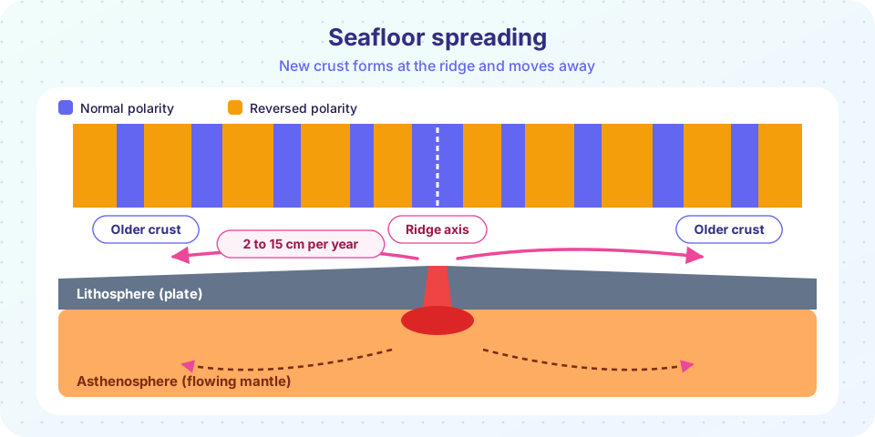
3. The magnetic stripes. Ships towing magnetometers found that the seafloor carries a pattern of magnetic stripes, parallel to the ridge and symmetric on both sides. The explanation, published by Fred Vine and Drummond Matthews in 1963, is elegant. When lava cools at the ridge, tiny iron-rich mineral grains lock in the direction of Earth's magnetic field at that moment. Earth's field flips from time to time (the last full reversal was about 780,000 years ago), so the stripes alternate between "normal" and "reversed" polarity. The ridge acts like a tape recorder, and the plates on each side carry copies of the same tape.
A fourth line of evidence followed. From 1968, the drilling ship Glomar Challenger brought up cores from many places. The oldest sediment directly above the crust was younger near the ridge and older farther away, and the sediment was thicker farther away. The ages fit the magnetic stripes exactly. Seafloor spreading was confirmed.
Plates and their boundaries
Earth's lithosphere is broken into about a dozen large plates and many smaller ones. They move on the weak asthenosphere below. The plates meet at three types of boundary:
| Boundary | Motion | Typical features | Example |
|---|---|---|---|
| Divergent | Plates move apart | Mid-ocean ridges, rift valleys, new crust | Mid-Atlantic Ridge |
| Convergent | Plates move together | Trenches, volcanic arcs, big earthquakes | Peru-Chile Trench, Japan Trench |
| Transform | Plates slide past | Faults, offsets in ridges, strong earthquakes | San Andreas Fault |
At a divergent boundary, decompression of the rising mantle makes it partly melt, and the melt forms basaltic crust. At a convergent boundary, the denser plate (usually oceanic) sinks beneath the other in a process called subduction. At a transform boundary, crust is neither made nor destroyed, but the plates grind past each other. On the seafloor, transform faults cut across ridges and offset them, leaving linear scars called fracture zones.
How fast, and what drives it?
Plates move at speeds comparable to the growth of a fingernail, about 2 to 15 cm per year. The Mid-Atlantic Ridge spreads slowly, around 2 to 3 cm per year in total; the East Pacific Rise spreads fast, up to about 15 cm per year. A speed of 5 cm per year is 50 km per million years, so in 100 million years an ocean can grow 5,000 km wide. That is how the Atlantic opened after Pangaea broke up.
Three forces are usually named:
- Slab pull: the cold, dense subducting plate sinks and pulls the rest of the plate along. This is thought to be the strongest.
- Ridge push: the elevated ridge pushes plates downslope, away from the crest.
- Mantle drag: flow in the asthenosphere can drag or resist the plate base.
Whole-mantle convection is still the broad frame, but the details of how it works are an active research topic.
Crust ages and the depth-age rule
Because crust is made at the ridge and moves away, its age increases with distance from the ridge. The oldest oceanic crust, in the western Pacific and in the Atlantic near the continents, is about 180 to 200 million years old. This is young compared with continental rocks, some of which are billions of years old, because old ocean floor is recycled at trenches.
Age also controls depth. Hot new crust is buoyant and stands high. As it moves away, it cools, contracts and sinks. For crust younger than about 70 million years, a widely used empirical relation is:
depth (m) = 2,500 + 350 × √age (million years)
Worked example. What depth do you expect for crust 25 million years old?
depth = 2,500 + 350 × √25 = 2,500 + 350 × 5 = 4,250 m
How far from the ridge is it, if the half-spreading rate is 3 cm per year? Convert: 3 cm/yr = 30 km per million years, so 25 × 30 = 750 km. So crust 750 km from the ridge crest is about 25 million years old and about 4,250 m deep. For crust older than about 70 million years, the real seafloor flattens out and is shallower than the rule predicts, because the plate is thermally stabilizing.
Common misconceptions
"Plates float on liquid magma." The asthenosphere is solid rock that flows very slowly, like a thick paste, over millions of years. Magma is only produced locally, at ridges, subduction zones and hotspots.
"Continents push through the ocean floor." Continents are parts of plates and ride along with them. There is no plowing.
"The Earth is getting bigger." New crust is made at ridges but destroyed at trenches, so the total surface area stays about the same.
"The Atlantic is shrinking because the Pacific has trenches." The Atlantic is currently widening; the Pacific is the one that is shrinking.
Try it
The first example is an interactive spreading simulation. Move the slider to change the half-spreading rate and see how wide the stripes of the last 3.6 million years become. The reversal times are a simplified version of the real record and are used for illustration.
The second example calculates and plots the depth-age rule, and tells you how far from the ridge a given age lies.
Press Run (or Ctrl + Enter) to see the result here.
Program input · what you'd type while the program runs
Type the answers before you press Run, one per line. Each time the program reads a line (with input()), it gets the next line from this box.
Check your understanding
Quick check · 5 questions
of 5 answered You scored / 5 · perfect!
-
1. What do symmetric magnetic stripes on either side of a ridge show?
Lava cooling at the ridge records the field direction; the plates carry mirrored records away on both sides. -
2. Which is a convergent plate boundary?
At a trench, one plate sinks beneath another; this is a convergent boundary. -
3. A plate moves 5 cm per year. How far does it move in 10 million years?
5 cm/yr = 50 km per million years, so 10 million years gives 500 km. -
4. Using depth = 2,500 + 350 × √age, what is the depth of 16-million-year-old crust?
√16 = 4, so depth = 2,500 + 350 × 4 = 3,900 m. -
5. Why is the oldest ocean floor only about 180 to 200 million years old?
Subduction destroys old oceanic crust, so none is much older than the Jurassic.
Summary
- Seafloor spreading makes new crust at mid-ocean ridges and carries it away on both sides; magnetic stripes and crust ages prove it.
- Plates meet at divergent, convergent and transform boundaries.
- Plates move 2 to 15 cm per year, driven mainly by slab pull, ridge push and mantle flow.
- Crust deepens with age by about 350 m times the square root of its age in millions of years.
- Ocean crust is recycled at trenches, so it is much younger than continental rock.
Track your progress
Create a free account to tick off lessons and pick up where you left off on any device.
of Oceanography lessons completed