


















Lesson 40 of 49 · Observation and Modelling
Ships, Floats and Satellites
Learn how the ocean is measured: CTD casts, moorings, Argo floats, gliders and satellite altimetry, SST and ocean color, and how sea surface height gives geostrophic currents.
In December 1872 HMS Challenger began a voyage that lasted three and a half years and visited 362 stations. At each one the crew lowered a rope with thermometers and sampling bottles over the side and waited hours for it to come up. The expedition's data filled 50 volumes and founded oceanography as a science (chapter 1). Today, a single Argo float produces a better temperature and salinity profile every ten days, and it does so unattended, for years, in a place no ship may visit in decades.
This lesson tours the instruments of modern oceanography: what each one measures, how it works and where it falls short. It also includes a worked example that turns a satellite measurement of sea surface height into a current speed.
What you will learn
- How a CTD works and why ships still matter
- The Argo float cycle and what Argo has changed
- How satellites measure sea surface height, temperature, color, wind, salinity and gravity
- How to compute a geostrophic current from sea surface slope
- What the limits of each method are
Key terms
CTD: an instrument that measures conductivity (to find salinity), temperature and depth (from pressure) as it is lowered through the water.
Argo: an international array of about 4,000 profiling floats that measure temperature and salinity in the upper 2,000 m.
Altimetry: measuring the height of the sea surface from space with a radar pulse.
Geostrophic current: a current in balance between the pressure gradient and the Coriolis force, found from the slope of the sea surface.
Mooring: an instrument line anchored to the seafloor with floats to hold it upright.
Ships and the CTD
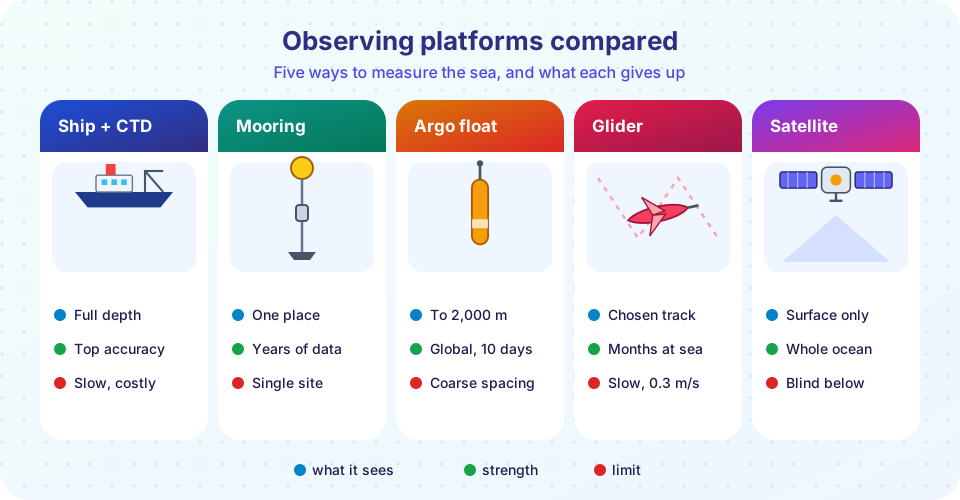
The standard instrument of oceanography since the 1960s is the CTD. It is lowered on a cable, often with a ring of bottles called a rosette, and it measures:
- Conductivity, from which salinity is calculated (chapter 3). Salt water conducts electricity better than fresh water.
- Temperature, to a precision of about 0.001 °C.
- Pressure, which gives depth (1 dbar is about 1 m).
Extra sensors measure dissolved oxygen, chlorophyll fluorescence, light and particles. The bottles are closed at chosen depths to bring up water for chemical analysis in the lab: nutrients, carbon, trace metals. Ships also carry acoustic Doppler current profilers (ADCPs), which measure currents by bouncing sound off particles in the water and reading the Doppler shift, and echo sounders for seafloor depth.
Ships are slow, and expensive to run, so international programs coordinate repeated sections: the World Ocean Circulation Experiment of the 1990s measured lines that GO-SHIP now repeats every decade or so. These careful measurements are the "gold standard" used to calibrate the floats.
Moorings and drifters
A mooring is a line anchored to the seafloor with instruments at several depths. It records temperature, salinity, currents and more, every few minutes for a year or longer. The TAO/TRITON array of about 70 moorings in the tropical Pacific was built after the great 1982-83 El Niño that no one had predicted (chapter 5); its data now feed El Niño forecasts. Another array at 26.5°N in the Atlantic, the RAPID array, has monitored the overturning circulation since 2004.
Surface drifters are floats with a sail-like drogue about 15 m below the surface that make them follow the current. A satellite tracks them. A global array of about 1,300 drifters gives direct measurements of the surface currents and SST.
Argo floats
The biggest change in oceanography in the last 25 years is Argo. An Argo float is a cylinder about 1.5 m long. It changes its buoyancy by pumping oil between an internal reservoir and an external bladder. In a typical 10-day cycle it:
- sinks to a parking depth of 1,000 m and drifts with the current for about 9 days;
- descends to 2,000 m;
- rises to the surface in about 6 hours, measuring temperature, salinity and pressure on the way;
- transmits its data by satellite and receives a new position, then sinks again.
A float can do 150 to 250 cycles over four to six years. Floats were deployed from about 2000, and the array reached the target of 3,000 in 2007. Today about 4,000 floats provide roughly 12,000 profiles a month, spaced about 300 km apart. All the data are free and available within a day. For the first time, scientists can watch the heat content, salinity and circulation of the upper 2,000 m of the global ocean evolve month by month. Newer floats add oxygen, nitrate, pH and chlorophyll sensors (BGC-Argo), and "Deep Argo" floats reach 4,000 to 6,000 m.
Gliders are autonomous vehicles that use the same buoyancy trick, with small wings that convert vertical motion into horizontal travel at about 0.3 m/s. They can be steered along a track for months, for example crossing a boundary current or following a hurricane's cold wake. Autonomous underwater vehicles (AUVs) and tethered remotely operated vehicles (ROVs) map the seafloor and sample the deep, and crewed submersibles like Alvin (first dive in 1964) take scientists to the bottom.
Satellites
Satellites cannot see through the ocean, but they measure the skin of the sea everywhere, often daily.
- Altimeters send a radar pulse down and time its return. The distance is
h = c t / 2, wherecis the speed of light. For an orbit at 1,336 km, the round trip is about 8.9 milliseconds; to measure height to 1 cm the timing must be accurate to about 67 picoseconds, and many corrections are needed (atmospheric delay, orbit, tides). The TOPEX/Poseidon mission (launched 1992) began a continuous record of global sea level, continued by Jason-1, -2, -3 and Sentinel-6. The SWOT satellite (2022) measures a swath rather than a line, revealing smaller eddies. - Radiometers measure sea surface temperature from the infrared (very accurate but blocked by cloud) and the microwave (sees through cloud but is coarser).
- Ocean color sensors, from CZCS (1978) and SeaWiFS (1997) to MODIS and PACE, measure chlorophyll (chapter 6).
- Scatterometers infer wind speed and direction from the roughness of the sea.
- Gravity missions GRACE (2002) and GRACE-FO (2018) measure changes in Earth's gravity, which reveal the mass of ice sheets and of the ocean directly.
- Salinity sensors on SMOS, Aquarius and SMAP measure it from microwave emission.
Worked example: a current from sea level
Sea surface height is not flat: it has hills and valleys of up to about 1 m, because of the geostrophic balance you saw in chapter 4. A geostrophic current flows along the contours of height, with the high side on its right in the Northern Hemisphere. Its speed is
u = (g / f) × (Δη / Δx)
where g = 9.81 m/s², f = 2Ω sin φ is the Coriolis parameter, Δη is the height difference and Δx the distance. Suppose an altimeter shows a 1.0 m drop across 100 km at 35°N. Then f = 2 × 7.292 × 10⁻⁵ × sin 35° = 8.37 × 10⁻⁵ s⁻¹, and
u = (9.81 / 8.37 × 10⁻⁵) × (1.0 / 100,000) = 1.17 m/s
That is the speed of the Gulf Stream. A change of 1 meter in sea level over 100 km is a tiny slope of 1 part in 100,000, yet it drives one of the fastest currents on Earth. Satellite altimetry turns height into a global map of currents.
Limits and care
Each method has biases. Ship data are biased toward shipping lanes and summer. Argo floats are scarce in marginal seas, under ice (though ice-capable floats now exist) and in coastal waters. Satellites are blocked by clouds in the infrared, and altimeters struggle near the coast. All measurements need calibration, quality control and uncertainty estimates. Combining platforms, the full observing system is stronger than any part, and it is maintained as a long-term commitment, the Global Ocean Observing System.
Common misconceptions
"A satellite can see the temperature at 1,000 m." Satellites see only the top skin of the ocean.
"Argo floats are tracked all the time." They are located only when they surface, and travel in the dark between profiles.
"Sea level is flat apart from waves and tides." Currents and heating create hills and valleys of up to about a meter.
"More data always means better answers." Data are useful when they are calibrated and cover the right places and times.
Try it
The first example is a geostrophic current calculator. Enter a height difference, a distance and a latitude to find the current speed.
Press Run (or Ctrl + Enter) to see the console output here.
No output.
The second example creates a synthetic CTD profile, a made-up but realistic shape with noise, and finds the mixed layer depth and the depth of the thermocline. It converts temperature and salinity to density using a simple linear equation of state. The data are generated, not measured.
Press Run (or Ctrl + Enter) to see the result here.
Program input · what you'd type while the program runs
Type the answers before you press Run, one per line. Each time the program reads a line (with input()), it gets the next line from this box.
Check your understanding
Quick check · 5 questions
of 5 answered You scored / 5 · perfect!
-
1. What does a CTD measure?
Salinity is calculated from conductivity, and depth from pressure. -
2. How long is a typical Argo cycle?
About 9 days parked at 1,000 m, then a descent to 2,000 m and a 6-hour rise with measurements. -
3. A satellite altimeter measures the height of the sea surface by...
The round-trip travel time of the pulse gives the distance to the surface. -
4. 1.0 m of sea surface drop over 100 km at 35°N gives a geostrophic current of about...
u = (g/f)(Δη/Δx) = (9.81 / 8.37 × 10⁻⁵) × 10⁻⁵ ≈ 1.17 m/s. -
5. Which cannot be measured directly by satellite?
Satellites sense the surface layer only; the interior needs in situ instruments such as Argo.
Summary
- CTDs on ships give the most accurate profiles and water samples; moorings give long time series at one place.
- Argo floats (about 4,000, 10-day cycles to 2,000 m) provide global interior coverage; gliders can be steered.
- Satellites measure the surface: height by radar altimetry (
h = ct/2), temperature, color, wind, salinity and gravity. - Sea surface slope gives geostrophic currents:
u = (g/f)(Δη/Δx). - Combining platforms offsets the limits of each.
Next: Models and Data
Track your progress
Create a free account to tick off lessons and pick up where you left off on any device.
of Oceanography lessons completed