


















Lesson 14 of 48 · Surveying and Mapping
Traverse, Coordinates and Area
Compute a closed traverse step by step: latitudes and departures, misclosure, precision, Bowditch adjustment, final coordinates and area by the coordinate method.
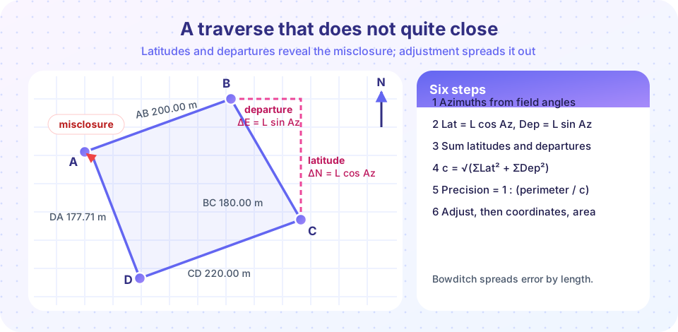
How do you fix the corners of a property, or the control points of a construction site, when they cannot all be seen from one place? You walk the boundary. A traverse is a chain of measured lines connected at stations. At every station you measure the angle; along every line you measure the distance. If the chain returns to its start, it is a closed traverse, and because it must close, it checks itself.
What you will learn
- How to turn a distance and azimuth into a latitude (north-south) and departure (east-west).
- How to find the misclosure and the relative precision of a traverse.
- How the Bowditch (compass) rule adjusts a traverse.
- How to compute coordinates and the enclosed area.
Key terms
- Latitude (ΔN): the north-south component of a line:
L cos Az. - Departure (ΔE): the east-west component:
L sin Az. - Misclosure (c): the gap between where the computed traverse ends and where it should end.
- Relative precision: misclosure divided into the perimeter, written
1 : P/c.
Step 1: latitudes and departures
With azimuth measured clockwise from north, a line of length L and azimuth Az has components
ΔN = L cos Az (latitude, positive to the north) and ΔE = L sin Az (departure, positive to the east).
Our example traverse has four legs, after the angles were used to carry azimuths around the loop:
| Line | Azimuth | Length (m) | Latitude (m) | Departure (m) |
|---|---|---|---|---|
| AB | 70°00′ | 200.00 | +68.404 | +187.939 |
| BC | 150°00′ | 180.00 | −155.885 | +90.000 |
| CD | 250°00′ | 220.00 | −75.244 | −206.732 |
| DA | 336°20′ | 177.71 | +162.764 | −71.335 |
Step 2: misclosure and precision
For a perfect closed traverse, all latitudes would add to zero, and so would all departures. Here ΣΔN = +0.039 m and ΣΔE = −0.129 m. The linear misclosure is
c = √(ΣΔN² + ΣΔE²) = √(0.039² + 0.129²) ≈ 0.135 m.
The perimeter is P = 777.71 m, so the relative precision is c / P = 0.135 / 777.71, which is about 1 : 5,800. In plain words: for every 5,800 m walked, the traverse is off by 1 m. Specifications set minimum precision by purpose. Rough property work may accept 1:5,000, while control surveys require far more. If the traverse fails, look for a blunder: check the longest legs and the angle that was measured only once.
Step 3: adjust by the Bowditch rule
The Bowditch (compass) rule assumes errors grow with length, so it spreads the misclosure in proportion to each leg's share of the perimeter:
correction to ΔN of a line = −ΣΔN × (L / P)
correction to ΔE of a line = −ΣΔE × (L / P)
For AB: L / P = 200 / 777.71 = 0.2572, so the latitude correction is −0.039 × 0.2572 = −0.010 m and the departure correction is +0.129 × 0.2572 = +0.033 m. After adjustment the latitudes sum to zero and so do the departures, so the polygon closes exactly. Other methods (the transit rule, least squares) exist and are preferred for precise work, but Bowditch is a fine introduction.
Step 4: coordinates
Start from a known station. Here A = (E 500.000, N 1,000.000). Add each adjusted departure to the easting and each adjusted latitude to the northing:
| Station | Easting (m) | Northing (m) |
|---|---|---|
| A | 500.000 | 1,000.000 |
| B | 687.972 | 1,068.394 |
| C | 778.002 | 912.500 |
| D | 571.306 | 837.245 |
| A (check) | 500.000 | 1,000.000 |
Getting back to A exactly is the proof that the adjustment was applied correctly.
Step 5: area by coordinates
With coordinates for every corner, the enclosed area follows from the shoelace formula:
Area = ½ | Σ (Ei × N(i+1) − E(i+1) × Ni) |, taking the stations in order and closing the loop.
For our traverse this gives about 37,234 m², which is 3.72 hectares (1 ha = 10,000 m²). The method works for any polygon, however irregular, as long as its sides do not cross themselves.
Common misconceptions
- "Adjustment makes the traverse accurate." It only distributes a closure error. A systematic error that cancels in the loop (for example, a wrong tape length that scales every side equally) can go unnoticed.
- "Latitude means a position on the globe." In traverse computations it simply means the north-south component of a line.
- "The bigger the misclosure, the more we should adjust." If the misclosure fails the tolerance, find and fix the blunder rather than adjust it away.
Try it
Press Run (or Ctrl + Enter) to see the result here.
Program input · what you'd type while the program runs
Type the answers before you press Run, one per line. Each time the program reads a line (with input()), it gets the next line from this box.
Press Run (or Ctrl + Enter) to see the console output here.
No output.
Check your understanding
Quick check · 4 questions
of 4 answered You scored / 4 · perfect!
-
1. A line is 100.00 m long with azimuth 90°. What are its latitude and departure?
Azimuth 90° is due east: ΔN = 100 cos 90° = 0 and ΔE = 100 sin 90° = 100. -
2. A traverse has ΣΔN = 0.030 m, ΣΔE = 0.040 m and perimeter 500 m. What is its relative precision?
c = √(0.03² + 0.04²) = 0.05 m. P/c = 500/0.05 = 10,000, so the precision is 1 : 10,000. -
3. In the Bowditch rule, the correction to a line is proportional to:
Longer lines are assumed to carry more error, so they receive a larger share of the correction. -
4. What is the area of the polygon (0,0), (10,0), (10,6), (0,6) by the shoelace formula?
It is a 10 × 6 rectangle: 60 m². The shoelace sum is 120 and half of it is 60.
Summary
- Convert each leg to latitude
L cos Azand departureL sin Az; their sums should be zero. - Misclosure
c = √(ΣΔN² + ΣΔE²)and relative precision1 : P/cjudge the traverse. - The Bowditch rule distributes the error in proportion to line length; closing back to the start proves it.
- Coordinates give area through the shoelace formula, for any polygon.
Next: Chapter 3 Review
Track your progress
Create a free account to tick off lessons and pick up where you left off on any device.
of Civil Engineering Fundamentals lessons completed