


















Lesson 12 of 48 · Surveying and Mapping
Measuring Distances and Angles
Learn taping, slope reduction, tape corrections for length, temperature and sag, plus angles, azimuths and bearings, with worked examples and calculators.
Two measurements fix almost everything on a site plan: how far and in which direction. Distance gives the size of the field; direction gives its shape. This lesson shows how surveyors measure both, how they remove the small errors hidden in a simple steel tape, and how they describe direction with azimuths and bearings.
What you will learn
- How to reduce a slope distance to a horizontal distance.
- How tape length, temperature and sag change a measured length, and how to correct them.
- How to convert between azimuths and bearings and carry azimuths around a traverse.
- How the angle sum of a closed polygon checks your angle measurements.
Key terms
- Slope distance (S): distance measured along the sloping ground.
- Horizontal distance (H): distance projected onto a level plane; this is what a map uses.
- Azimuth: direction measured clockwise from north, from 0° to 360°.
- Bearing: direction written as N or S, an angle up to 90°, then E or W.
Measuring distance
Taping uses a steel or fiberglass tape. It is slow but simple and very accurate over short distances. Electronic distance measurement (EDM) sends light or infrared to a prism or reflecting target and measures the travel time or phase shift. A total station does this and reads the angle at the same time. EDM is quick and covers long distances; its main corrections are for atmospheric conditions, about 1 mm per kilometer for each 1 ppm.
From slope to horizontal
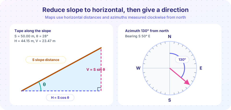
If a distance is measured along a slope at an angle θ to the horizontal, the horizontal distance is
H = S cos θ, and the vertical difference is V = S sin θ.
Example: S = 50.00 m, θ = 28°. Then H = 50.00 × cos 28° = 44.15 m and V = 50.00 × sin 28° = 23.47 m. When you know the height difference h rather than the angle, use H = √(S² − h²).
Tape corrections
A tape is calibrated at a standard temperature (commonly 20 °C) and tension. In the field it can be a little longer or shorter, so each reading needs correcting:
- Tape length:
C = S × (actual length − nominal length) / nominal length. If the tape is actually longer than its nominal value, the true distance is greater than the reading, so the correction is positive. - Temperature:
Ct = α (T − T0) × S, withα ≈ 11.6 × 10⁻⁶ per °Cfor steel. A warm tape expands, so the correction is positive above standard temperature. - Sag: an unsupported tape hangs in a curve, so its two ends are closer than the marks say.
Cs = −w² L³ / (24 P²), wherewis the tape's weight per meter (N/m),Lthe unsupported length andPthe pull (N). The correction is always negative. Supporting the tape along its length removes it, and more tension reduces it. - Slope: reduce to horizontal as above.
Worked example. A 30 m tape that is actually 30.008 m long at 20 °C measures a slope distance of 87.435 m at 32 °C, with a height difference of 2.10 m between the ends. The tape is supported throughout, so sag is ignored.
- Tape length:
87.435 × 0.008 / 30 = +0.0233 m. - Temperature:
11.6 × 10⁻⁶ × (32 − 20) × 87.435 = +0.0122 m. - Corrected slope distance:
87.435 + 0.0233 + 0.0122 = 87.4705 m. - Horizontal distance:
√(87.4705² − 2.10²) ≈ 87.445 m.
The total corrections are about 35 mm in 87 m, a relative size of roughly 1 part in 2,500. Small as it seems, ignoring them would be unacceptable for accurate work.
Directions: azimuth and bearing
An azimuth goes clockwise from north: east is 90°, south 180°, west 270°. A bearing names the quadrant: an azimuth of 130° lies in the south-east quadrant, 50° from south, so its bearing is S 50° E. Convert by quadrant:
| Quadrant | Azimuth range | Bearing from azimuth Az |
|---|---|---|
| NE | 0°-90° | N Az E |
| SE | 90°-180° | S (180° − Az) E |
| SW | 180°-270° | S (Az − 180°) W |
| NW | 270°-360° | N (360° − Az) W |
The back azimuth of a line is its forward azimuth plus or minus 180°. If AB has azimuth 60°, then BA is 240°.
Angles and carrying azimuths
A theodolite or total station reads the horizontal angle to the right: clockwise from the backsight to the foresight. To carry direction forward:
forward azimuth = back azimuth + angle to the right (subtract 360° if the result passes 360°).
Example: AB has azimuth 60°. At B the angle from A (backsight) to C (foresight), turned clockwise, is 110°. The back azimuth BA is 240°, so Az(BC) = 240° + 110° = 350°.
Surveyors measure with the telescope both ways ("face left" and "face right") and average the two readings, which cancels several instrument errors.
Closure check. The interior angles of a closed polygon with n sides must add up to (n − 2) × 180°. For a quadrilateral that is 360°. If your four angles add to 360°00′40″, the angular misclosure is 40″. A common tolerance has the form k √n, where k is a constant of about 15 to 30 seconds for ordinary work and n is the number of angles; your project specification sets the real value. If the misclosure is acceptable, spread it equally among the angles.
Common misconceptions
- "A taped slope distance can go straight on the plan." Plans need horizontal distances, so you must reduce first.
- "Sag correction can be positive." Sag always shortens the span between the marks, so the correction is negative.
- "Bearing and azimuth are interchangeable numbers." They name the same direction in two different formats; always state which one you use.
Try it
Press Run (or Ctrl + Enter) to see the result here.
Program input · what you'd type while the program runs
Type the answers before you press Run, one per line. Each time the program reads a line (with input()), it gets the next line from this box.
Press Run (or Ctrl + Enter) to see the console output here.
No output.
Check your understanding
Quick check · 5 questions
of 5 answered You scored / 5 · perfect!
-
1. A slope distance of 80.00 m is measured at θ = 10°. What is the horizontal distance (cos 10° = 0.9848)?
H = 80.00 × 0.9848 = 78.78 m. -
2. Which tape correction is always negative?
Sag draws the tape ends together, so the true distance is shorter than the reading. -
3. What is the bearing of azimuth 250°?
250° is in the south-west quadrant, 70° beyond south: S 70° W. -
4. AB has azimuth 120°. What is the back azimuth BA?
Add 180°: 120° + 180° = 300°. -
5. The interior angles of a five-sided closed traverse should sum to:
(n − 2) × 180° = 3 × 180° = 540°.
Summary
- Maps need horizontal distances:
H = S cos θ. - Correct taped lengths for tape error, temperature (
α ≈ 11.6 × 10⁻⁶ /°C) and sag, which is always negative. - Azimuths run clockwise from north; bearings name the quadrant; back azimuth adds or subtracts 180°.
- Forward azimuth = back azimuth + angle to the right; closed-polygon angles must sum to
(n − 2) × 180°.
Next: Leveling and Elevations
Track your progress
Create a free account to tick off lessons and pick up where you left off on any device.
of Civil Engineering Fundamentals lessons completed