


















Lesson 15 of 48 · Surveying and Mapping
Chapter 3 Review: Surveying and Mapping
Review surveying: scale and contours, slope reduction and tape corrections, azimuths, leveling, traverse misclosure, adjustment and area, with a ten-question quiz.
Surveying turns a messy landscape into numbers you can trust. This chapter taught you the four building blocks: distance, direction, height and position. Each comes with a check, so you know when to believe your numbers. Use this page to review the checks and try a combined calculator.
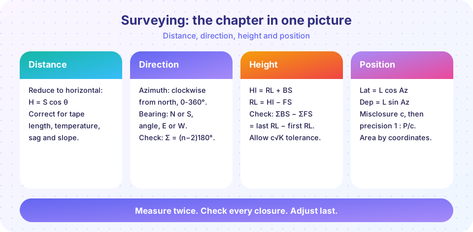
Recap table
| Lesson | Big idea | Key formulas |
|---|---|---|
| Chapter 3 Overview | Datums, scale, contours, error types | Ground = map × scale; slope = interval ÷ distance |
| Measuring Distances and Angles | Reduce and correct distances; azimuth and bearing | H = S cos θ, Ct = α (T − T0) S, sag −w²L³/(24P²) |
| Leveling and Elevations | Height difference from staff readings | HI = RL + BS, RL = HI − FS, ΣBS − ΣFS = ΔRL |
| Traverse, Coordinates and Area | Latitude, departure, misclosure, Bowditch, area | ΔN = L cos Az, ΔE = L sin Az, precision 1 : P/c |
Try it
Press Run (or Ctrl + Enter) to see the result here.
Program input · what you'd type while the program runs
Type the answers before you press Run, one per line. Each time the program reads a line (with input()), it gets the next line from this box.
Press Run (or Ctrl + Enter) to see the console output here.
No output.
Check your understanding
Quick check · 10 questions
of 10 answered You scored / 10 · perfect!
-
1. On a map at 1:5,000, a road measures 3.6 cm. How long is it on the ground?
3.6 cm × 5,000 = 18,000 cm = 180 m. -
2. A slope distance of 60.00 m is measured at 12° (cos 12° = 0.9781). H = ?
H = 60.00 × 0.9781 = 58.69 m. -
3. Which correction is always negative?
Sag pulls the tape ends together, so the true distance is shorter than the reading. -
4. What is the bearing for azimuth 300°?
300° is in the north-west quadrant, 360° − 300° = 60° from north: N 60° W. -
5. BM = 75.000 m, BS = 2.000 m, FS = 1.250 m on a new point. Its RL is:
HI = 77.000, RL = 77.000 − 1.250 = 75.750 m. -
6. A bigger staff reading means the point is:
The reading is measured down from the line of sight, so a bigger reading means a lower point. -
7. Why keep backsight and foresight distances equal?
Distance-dependent errors affect both sights equally and cancel in the difference. -
8. A traverse has c = 0.20 m and perimeter 1,000 m. Its precision is:
P/c = 1,000 / 0.20 = 5,000. -
9. In the Bowditch rule the correction to each line depends on:
Correction = −(sum of error) × (L / P). -
10. The interior angles of a six-sided closed traverse should sum to:
(6 − 2) × 180° = 720°.
Summary
- Maps rely on scale, datums and contours; blunders, systematic and random errors need different cures.
- Reduce slope distances and correct tapes; carry azimuths with
back azimuth + angle right. - Leveling uses
HI = RL + BSandRL = HI − FS, with arithmetic and closing checks. - Traverses are checked by misclosure and precision, adjusted by Bowditch and turned into coordinates and area.
- Chapter 4 turns to the materials that engineers measure, specify and build with.
Track your progress
Create a free account to tick off lessons and pick up where you left off on any device.
of Civil Engineering Fundamentals lessons completed