


















Lesson 11 of 48 · Surveying and Mapping
Chapter 3 Overview: Surveying and Mapping
An introduction to land surveying: what surveyors measure, how maps use scale, datums and contours, and how errors are classed and controlled.
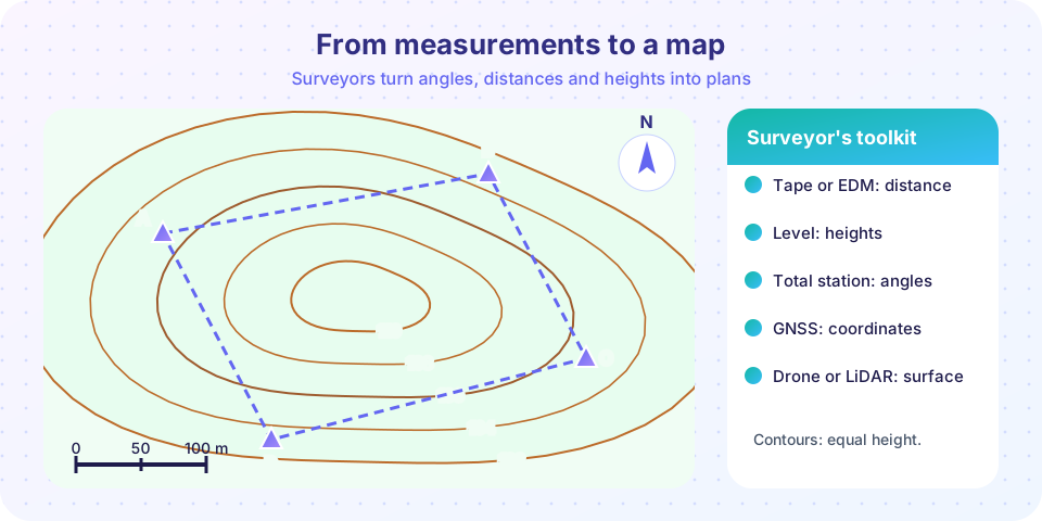
Before anyone digs a foundation or lays a road, someone must know where things are. Surveying answers that. A surveyor measures distances, angles and heights on the ground, then turns those numbers into coordinates, maps and setting-out marks. When the building later appears in exactly the right place, with the floor at exactly the right height, you are seeing surveying at work.
What you will learn
- The main kinds of survey and the measurements surveyors make.
- How maps use scale, datums and contours to describe a landscape.
- The difference between blunders, systematic errors and random errors, and between accuracy and precision.
- What the rest of the chapter covers.
Key terms
- Datum: a reference surface for heights or positions, such as mean sea level.
- Scale: the ratio between a distance on the map and the same distance on the ground.
- Contour: a line joining points of equal elevation.
- Benchmark (BM): a marked point whose height is known.
The big picture
What a surveyor measures
What comes out
How we trust it
A measurement without a check is only a guess.
Kinds of survey
- Topographic survey: records the shape of the ground and everything on it (trees, fences, buildings) for design.
- Boundary (cadastral) survey: fixes legal property lines.
- Engineering or construction survey: sets out the position of roads, pipes and structures and checks what has been built.
- Control survey: establishes a framework of precisely known points that other surveys attach to.
- Geodetic versus plane surveying: over small areas the Earth is treated as flat (plane surveying). Over large areas its curvature matters (geodetic surveying), and positions are tied to a mathematical model of the Earth.
Instruments in one paragraph
Old surveyors used chains: Gunter's chain was 66 feet long. Today, steel tapes still serve for short, careful work. A level gives a horizontal line of sight for heights. A theodolite measures horizontal and vertical angles. A total station is a theodolite with an electronic distance meter, so it records angle and distance together. GNSS receivers (GPS and its relatives) position points from satellites, and with correction data can reach centimeter level. Laser scanners and drones capture millions of points of a surface.
Datums, scale and contours
Heights are measured from a datum, often mean sea level. A height above that datum is a reduced level (RL) or elevation. Positions use a coordinate system such as eastings and northings in meters.
A map's scale links paper to ground. At 1:2,500, 1 cm on paper equals 2,500 cm = 25 m on the ground, so a distance of 4.2 cm on the map is 105 m on the ground. Smaller scale numbers, such as 1:500, show more detail over a smaller area.
Contours show relief. Each line joins points of equal height, and the vertical gap between neighboring lines is the contour interval (for example 2 m). Close contours mean a steep slope, wide spacing means gentle ground, and closed rings mean a hill or a depression. You can find the slope between two contours as slope = interval ÷ horizontal distance: contours 2 m apart and 20 m apart horizontally give a 10 percent slope.
Errors, accuracy and precision
No measurement is perfect. Surveyors group errors as:
- Blunders: plain mistakes, such as misreading 3.45 as 3.54. They are removed by checking.
- Systematic errors: repeat in the same direction, such as a tape that is 5 mm too long. They are corrected by calibration and calculation.
- Random errors: small, unpredictable, equally likely to be positive or negative. They are reduced by repeating measurements and averaging.
Precision is how closely repeated measurements agree with each other. Accuracy is how close they are to the true value. You can be precise but inaccurate (a tape that is consistently too long), so both ideas matter.
Common misconceptions
- "A more precise instrument always gives accurate results." A badly calibrated instrument can repeat the same wrong value very precisely.
- "Averaging removes all errors." It reduces random errors only; blunders and systematic errors remain.
- "Contour lines can cross." Except at a vertical cliff or overhang, a contour never crosses another one.
In this chapter
- Measuring Distances and Angles: tape corrections, slope reduction, azimuth and bearing.
- Leveling and Elevations: backsights, foresights and reduced levels.
- Traverse, Coordinates and Area: closing a loop, adjusting it and finding area.
- Chapter 3 Review: recap and quiz.
Try it
Press Run (or Ctrl + Enter) to see the result here.
Program input · what you'd type while the program runs
Type the answers before you press Run, one per line. Each time the program reads a line (with input()), it gets the next line from this box.
Press Run (or Ctrl + Enter) to see the console output here.
No output.
Press Run (or Ctrl + Enter) to see the result here.
Program input · what you'd type while the program runs
Type the answers before you press Run, one per line. Each time the program reads a line (with input()), it gets the next line from this box.
Check your understanding
Quick check · 4 questions
of 4 answered You scored / 4 · perfect!
-
1. On a 1:2,500 map, 4 cm represents what ground distance?
4 cm × 2,500 = 10,000 cm = 100 m. -
2. A tape that is 5 mm too long causes which kind of error?
It repeats in the same direction every time, so it is systematic and can be corrected. -
3. What does close contour spacing show?
The same height change over a shorter distance means a steeper slope. -
4. What does a total station measure?
A total station combines an angle-measuring theodolite with an electronic distance meter.
Summary
- Surveying fixes where things are: distances, angles and heights become maps, coordinates and setting-out marks.
- Datums, scale and contours let a flat drawing describe real ground.
- Blunders, systematic errors and random errors need different cures: checking, calibration and repetition.
- The following lessons teach distance and angle, leveling and traverse computation.
Track your progress
Create a free account to tick off lessons and pick up where you left off on any device.
of Civil Engineering Fundamentals lessons completed