


















Lesson 48 of 48 · Projects and Practice
Further study: where geology goes next
Plan your next steps after the geology course: related subjects on this site, skills such as GIS and data analysis, field practice and a personal project plan.
You have now covered a full tour of geology: how rocks bend and break, how Earth's history is ordered and dated, how resources form and hazards strike, and how geologists read maps in the field. That is a real foundation. The next question is where to take it, and the answer depends on what you enjoy most. Geology touches physics, chemistry, biology, ocean and climate science, engineering and data analysis, and each connection leads to a deeper subject.
This final lesson is a map of the possible routes. It names related courses on this site, the practical skills that employers and universities value, and a plan for building your own project. It also gives you a way to turn the weak spots of this course into a revision schedule.
What you will learn
- Which related subjects extend what you have learned.
- Which practical skills make a geologist effective.
- How to run a small independent project and keep good records.
- How to turn your quiz results into a revision plan.
Routes into related subjects
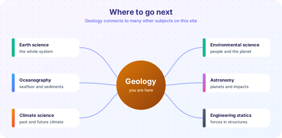
The whole Earth system. If you liked seeing how rocks, water, air and life connect, continue with Earth science. It places geology in the context of weather, oceans, the atmosphere and the solar system, and it gives you the big picture that specialists build on.
The oceans. Two thirds of Earth's surface is under water, and most plate boundaries, sediment and tsunamis are there. Oceanography takes the seafloor spreading, sediment and tsunami ideas of this course and adds currents, waves, tides and marine chemistry.
Climate, past and future. The rock record is one of the best archives of past climate: ice cores, sediments, fossils and isotopes. Climate science builds on the time scale, mass extinction and carbon cycle ideas here and connects them to present and future change.
People and the planet. Resources and hazards have social consequences. Environmental science covers water, energy, pollution, land use and sustainability, and how societies manage risk, which continues the last part of Chapter 7.
Planets and origins. The age of Earth, impacts, and the formation of the solar system lead to Astronomy. Planetary geology applies the same tools, such as crater counting and rock-type mapping, to the Moon, Mars and beyond.
Forces and structures. If you enjoyed the stress and strain calculations, Engineering statics shows how the same ideas of force, equilibrium and stress are used to design bridges, dams and tunnels. For deeper background in mechanics, see Physics: mechanics.
Numbers and uncertainty. Nearly every geologic conclusion comes with error bars: ages, magnitudes, flood probabilities. Statistics and probability teaches how to describe and reduce uncertainty, which is what turns a measurement into evidence. For the chemistry of minerals and isotopes, see Chemistry foundations.
Skills worth building
Geology is a practical subject, and some skills are learned only by doing.
- Reading maps and sections fluently. Practice on real geologic maps from a national or regional geological survey. Pick a small area, identify every unit, trace the contacts and draw your own cross section. Compare it with the survey's.
- Geographic information systems (GIS). Modern maps are digital. A GIS lets you overlay geology, elevation, rainfall and roads, and measure distances and areas accurately. Free tools exist, and the ideas follow directly from the scale, coordinate and contour skills of Chapter 8.
- Remote sensing. Satellite images and elevation models reveal faults, folds and landslides over huge areas.
- Data analysis in Python. You have used NumPy and Matplotlib throughout the course. The next steps are reading real data files, fitting models and quantifying uncertainty. Earthquake catalogs and river gauge records are free and make good practice data.
- Technical writing. A geologic report needs a clear structure: question, method, observations, interpretation, uncertainty. Practice writing one page about one outcrop.
- Field fitness and safety. Learn first aid, navigation and weather awareness. Join a local geology club or an organized field trip before going into remote areas alone.
Ideas for your own project
A good project is small enough to finish and specific enough to say something. Some ideas, each using skills from this course:
- Map your local geology. Find the survey map for your area, visit three outcrops (road cuts, quarries, river banks, always with permission and safely), record strike and dip, and write a one-page story of the area.
- Make a hazard profile. Pick a place and list which hazards it faces: earthquakes, floods, landslides, volcanoes. Use real records to estimate probabilities and write a short risk summary using hazard, exposure and vulnerability.
- Date a sequence. Take a published cross section with radiometric ages and compute rates and gaps, as in the project lesson.
- Build a calculator. Turn the formulas of the cheat sheet into a small tool in Python or JavaScript, with unit checks and tests.
- Compare water and rock. Measure the porosity of different sands and gravels by pouring water into a measured volume, and relate the results to permeability. This is a home-scale version of the aquifer ideas in Chapter 7. Keep it simple and safe.
Whatever the project, keep a notebook: the question, what you did, what you saw and what you think it means, each in its own section.
Turn your results into a plan
Use the self-check tools from the practice problem set and the quizzes to find the topics you find hardest. The first TryIt below turns scores into a revision plan: list your score for each chapter, and it prints the order in which to revisit them.
Press Run (or Ctrl + Enter) to see the result here.
Program input · what you'd type while the program runs
Type the answers before you press Run, one per line. Each time the program reads a line (with input()), it gets the next line from this box.
The planner only sorts the numbers you give it. It cannot know how well you understand a topic.
Press Run (or Ctrl + Enter) to see the console output here.
No output.
Keep the habits
The most valuable things you take from this course are habits of thought more than facts. Separate observation from interpretation. Ask what evidence would change your mind. Put numbers on claims and say how uncertain they are. Think in time: how long did this take, and what came before? Think in three dimensions: what would a slice through this look like? These habits apply far beyond geology, and they are what good scientists, engineers and informed citizens share.
Check your understanding
Quick check · 3 questions
of 3 answered You scored / 3 · perfect!
-
1. Which subject would best extend the stress and strain calculations into the design of bridges and dams?
Statics uses force, equilibrium and stress to analyze structures. -
2. Which skill makes it possible to overlay geology, elevation and rainfall on one digital map?
A geographic information system combines map layers. -
3. Which statement describes a good independent project?
Scope and records are what make a project useful.
Summary
- Geology connects to Earth science, oceanography, climate, environment, astronomy, engineering and statistics.
- Valuable skills include map reading, GIS, remote sensing, data analysis, writing and field safety.
- A small, well-recorded project teaches more than reading alone.
- The habits of separating observation from interpretation, quantifying uncertainty and thinking in time and three dimensions carry across subjects.
Next: back to the Geology course page
Track your progress
Create a free account to tick off lessons and pick up where you left off on any device.
of Geology lessons completed