


















Lesson 41 of 48 · Field Methods and Maps
Cross sections and field notes
Learn to draw a geologic cross section from a map, calculate apparent dip and bed thickness, correct compass declination and keep a clear, safe field notebook.
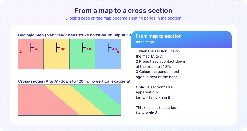
A geologic map is a view from above. A cross section is a view from the side: a picture of what you would see if you sliced the ground along a line and looked at the cut face. Because most rocks are hidden under soil and vegetation, drawing a section is an act of prediction. You take the dips, contacts and faults at the surface and extend them downward using geometry. If your prediction is right, a drill hole will cut the layers where the section says they should be.
Nothing in the section is invented from imagination: it is built from measurements, and every line has a reason. This lesson shows the geometry of the process, gives you the formulas for apparent dip and thickness, and finishes with field notes, which are the record that all maps and sections come from.
What you will learn
- The steps to construct a cross section from a map.
- True dip, apparent dip and the formula that links them.
- How to calculate the true thickness of a bed from the map.
- What to put in a field notebook, how to correct for declination and how to work safely.
Key terms
Cross section is a diagram of a vertical slice through the ground, showing rock units and structures.
True dip is the dip measured perpendicular to the strike.
Apparent dip is the dip seen in a vertical plane that is not perpendicular to the strike; it is always less than or equal to the true dip.
Vertical exaggeration is the ratio of the vertical scale to the horizontal scale of a section.
Declination is the angle between true north and magnetic north.
Drawing a cross section
Follow these steps for a section along a line A to A′ on a map.
- Choose the line. A good section runs perpendicular to the strike of the main structures, so that the dips you see are true dips.
- Draw the topographic profile along the line (see the previous lesson), and mark where each contact and fault crosses the line.
- Plot dips. At each contact, draw a short line at the measured dip, using a protractor. If the section is not perpendicular to strike, convert to apparent dip first.
- Project the contacts downward, extending them as straight lines in simple dipping beds, or as smooth curves in folds. Keep the thickness of each unit constant unless there is a reason to change it.
- Faults: draw the fault plane at its dip and shift the units on either side by the offset, with arrows showing relative motion.
- Color and label. Use the same colors as the map. Mark inferred parts with dashed lines.
- Add scale, vertical exaggeration, orientation of the line (for example, west on the left) and a title.
Rules of thumb: do not extend a contact deeper than you have reason to believe (the further from the surface, the more uncertain), and always check that the beds can be restored to their original positions. Balanced cross sections test this by unfolding and unfaulting the section; if the beds cannot be put back without gaps or overlaps, the interpretation is wrong.
Apparent dip
A vertical section that is not perpendicular to strike cuts the bed at a gentler angle than the true dip. If the section line makes an angle β with the strike of the bed, the apparent dip α satisfies
tan α = tan δ × sin β
where δ is the true dip. Check the extremes: if β = 90° (perpendicular to strike), sin β = 1 and α = δ. If β = 0° (along strike), α = 0, because moving along a level line does not go up or down.
Example: a bed has δ = 40° and the section line makes β = 30° with the strike. Then tan α = tan 40° × sin 30° = 0.839 × 0.5 = 0.420, so α = 22.8°. If you drew 40° on that section, the bed would look wrongly steep.
Thickness from a map
If a bed crops out on flat ground with an outcrop width w measured perpendicular to strike, its true thickness is
t = w × sin δ
A band 100 m wide with a dip of 40° corresponds to t = 100 × 0.643 = 64.3 m. Where the ground slopes, the formula needs a correction, but for flat ground it gives a good first estimate. Thickness is useful: it tells you how much sediment accumulated, and how much of a resource such as coal lies below your feet.
Field notes
The notebook is the primary record, and good geologists write in it at the outcrop, not afterward. Include the following.
- Header: date, time, place (GPS coordinates with datum, and a written description), weather, and who was there.
- Outcrop number that you also mark on the map.
- Observations, kept separate from interpretation:
- Rock type and color on a fresh surface and on a weathered surface.
- Grain size, estimated with a hand lens and a grain-size card. On the Wentworth scale, clay is under 0.004 mm, silt up to 0.0625 mm, sand up to 2 mm and gravel above 2 mm.
- Minerals and hardness: a fingernail scratches materials up to about 2.5 on Mohs scale, a copper coin about 3.5, and a steel knife about 5.5.
- Reaction to dilute hydrochloric acid (about 10 percent): calcite fizzes at once, dolomite only when powdered.
- Sedimentary structures: bed thickness, cross-bedding, ripple marks, graded beds, fossils, burrows.
- Structures: strike and dip of bedding, joints, faults, folds, with measurements.
- Sketches: labelled, with a scale and an orientation (for example, view toward the north). A sketch forces you to look.
- Photos: include a scale such as a hammer or a coin, and note the direction and photo number in the book.
- Samples: a number matching the bag, the location and the reason for collection.
Declination
The compass needle points to magnetic north. To convert a magnetic azimuth to a true azimuth:
true azimuth = magnetic azimuth + declination (east declination positive, west negative)
If declination is 10° E, a magnetic reading of 045° is 055° true. Declination changes from place to place and slowly over years, so look it up for your location and date, and either set it on the compass or record that you did not. Write which you used in the notebook.
Equipment and safety
Carry a hammer, hand lens (10×), compass-clinometer, notebook and pencil (pens fail in the rain), grain-size card, a small bottle of dilute acid, a map, a GPS or a phone with offline maps, sample bags, first-aid kit, water and food. Safety is a core field skill:
- Wear eye protection when hammering, and do not hammer other people's outcrops without permission, or in protected sites.
- Tell someone your plan and expected return time. Check the weather and avoid exposed ridges in storms.
- Watch for rockfall under cliffs and road cuts; a hard hat is sensible. Stay off unstable slopes and keep a safe distance from the edge.
- Respect land access, rules and local people. Many parks and reserves forbid collecting. Take photos, not specimens, when in doubt.
- Treat old mines and quarries as hazards. Never enter old workings.
- Leave no trace. Carry out your waste, and leave outcrops as you found them for the next geologist.
Common misconceptions
"A cross section is a photograph of the ground." It is an interpretation constrained by data; the parts far below the surface are inferred.
"Dip on a section always equals true dip." Only when the section is perpendicular to strike.
"Field notes can be tidied later." Notes written later lose details and mix observation with memory. Rewrite neatly if you like, but keep the original.
"Compass north is true north." The difference can be several degrees, or more than 20° in some places.
Try it
Press Run (or Ctrl + Enter) to see the result here.
Program input · what you'd type while the program runs
Type the answers before you press Run, one per line. Each time the program reads a line (with input()), it gets the next line from this box.
Press Run (or Ctrl + Enter) to see the result here.
Program input · what you'd type while the program runs
Type the answers before you press Run, one per line. Each time the program reads a line (with input()), it gets the next line from this box.
Press Run (or Ctrl + Enter) to see the console output here.
No output.
Check your understanding
Quick check · 6 questions
of 6 answered You scored / 6 · perfect!
-
1. A section line runs along the strike of a bed. The apparent dip is:
Along strike, tan α = tan δ × sin 0 = 0. -
2. True dip 60° and β = 90° give an apparent dip of:
At 90° to strike the section shows the true dip. -
3. A bed crops out 80 m wide on flat ground and dips 30°. Its true thickness is:
t = 80 × sin 30° = 40 m. -
4. A compass reads 120° with a declination of 8° W. The true azimuth is:
West declination is negative: 120 − 8 = 112°. -
5. Which belongs in the 'observation' part of a field note?
Observations are what you directly see; the rest are interpretations. -
6. Why should a good cross section run perpendicular to strike?
At 90° to strike, apparent dip equals true dip.
Summary
- A cross section projects surface geology downward using dip, thickness and structure; it is a prediction that drilling can test.
- Apparent dip:
tan α = tan δ sin β; it equals true dip only for sections at 90° to strike. - True thickness on flat ground is
t = w sin δ. - Field notes separate observation from interpretation and record location, rocks, structures, sketches and samples.
- True azimuth = magnetic azimuth + declination (east positive). Work safely and ethically.
Next: Chapter 8 review
Track your progress
Create a free account to tick off lessons and pick up where you left off on any device.
of Geology lessons completed