


















Lesson 38 of 48 · Field Methods and Maps
Field methods and maps: the big picture
An overview of how geologists work in the field: reading topographic and geologic maps, measuring strike and dip, drawing cross sections and keeping notes.
Geology happens outdoors. A geologist's most important instruments are a compass, a hand lens, a notebook and a map. Rocks are exposed only in scattered outcrops, so geologists must read a few places carefully and then reason about everything between them. The result is a geologic map, a picture of what lies beneath the soil, and a cross section, a picture of what a vertical slice through the ground would show.
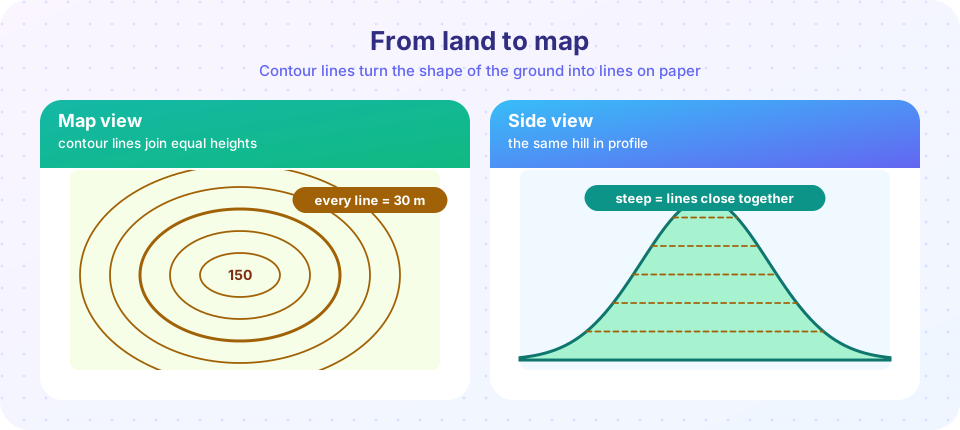
This chapter teaches the skills that turn measurements into pictures. You will learn to read the shape of the land from contour lines, measure the orientation of tilted layers, interpret a geologic map and draw your own cross section. These tools connect everything you learned in earlier chapters: layers, folds, faults, time and resources.
What you will learn in this chapter
- How to read scale, contours and gradient on a topographic map.
- How to measure and write down strike and dip, and how to use apparent dip.
- How to read a geologic map and draw a cross section.
- How to keep a useful field notebook and work safely.
The chapter at a glance
Step 1: read the land
Step 2: measure the rocks
Step 3: draw the pattern
Step 4: tell the story
Your map of the chapter
| Lesson | What it covers |
|---|---|
| Topographic maps | Scale, contour lines, gradient and profiles. |
| Strike, dip and geologic maps | Measuring orientation, the three-point problem, outcrop patterns and map symbols. |
| Cross sections and field notes | Drawing a section, apparent dip, thickness, vertical exaggeration and field practice. |
| Chapter review | One picture, one table and ten questions. |
Observation first, interpretation second
A principle of field geology is to separate what you see from what you think it means. "Medium-grained gray rock with white blocky crystals" is an observation. "Granite" is an interpretation. If you write only the interpretation, the next person cannot check your reasoning. Good notebooks separate the two and record where each observation was made.
Another principle is multiple working hypotheses: keep several explanations alive until the evidence rules some out. A map is a model that predicts what you should find at the next outcrop. When the prediction fails, the model improves.
Why maps matter beyond geology
Maps are among the oldest scientific tools, and learning to read one carefully transfers to many fields: planning a road, locating a water supply, predicting a flood path or siting a wind farm. A geologic map adds the hidden dimension of depth, because a pattern of colors at the surface can be turned into a three-dimensional model. The best way to learn is with a real map and a pencil: trace a contour, mark a ridge and a stream, then predict the shape of the land before you check the profile. In the field the same loop applies: observe, map, predict the next outcrop, and test the prediction by walking there.
Because so much of this chapter is about method, expect to practice as much as you read. Each lesson ends with calculations you can check and a drawing you can attempt on paper.
Try it
Press Run (or Ctrl + Enter) to see the result here.
Program input · what you'd type while the program runs
Type the answers before you press Run, one per line. Each time the program reads a line (with input()), it gets the next line from this box.
The landscape above is a made-up surface used for demonstration, not a real place.
Press Run (or Ctrl + Enter) to see the console output here.
No output.
Check your understanding
Quick check · 3 questions
of 3 answered You scored / 3 · perfect!
-
1. What is the best description of an outcrop?
Outcrops are the exposures from which geologists build maps. -
2. Which is an observation rather than an interpretation?
Observations describe what you see; interpretations explain it. -
3. A geologic map and a cross section differ because:
A map looks down on the surface; a cross section shows a vertical slice.
Summary
- Field geology builds maps and sections from scattered outcrops.
- Contours show the shape of the land; strike and dip show the orientation of rock layers.
- Keep observations separate from interpretations and test explanations against new data.
- The chapter covers topographic maps, geologic maps, cross sections and field practice.
Next: Topographic maps
Track your progress
Create a free account to tick off lessons and pick up where you left off on any device.
of Geology lessons completed