


















Lesson 43 of 48 · Projects and Practice
Case study: reading a canyon
Apply stratigraphy, unconformities, dating and structure to the Grand Canyon: read its rock layers from rim to river and estimate how fast the river cut down.
The Grand Canyon is the classic outdoor classroom for geology, because it slices open about 1.8 kilometers of rock and leaves the layers on show. Everything in the previous chapters can be used here: superposition and cross-cutting, unconformities, fossils and radiometric ages, folds and faults, topography and cross sections, even hazards such as rockfalls and flash floods.
This case study walks from the rim to the river, reading each layer as evidence. It is a way to practice the skill that matters most in geology: turning a landscape into a sequence of events. The facts below are rounded and some, especially the age of the canyon itself, are still debated, and the lesson tells you where.
What you will learn
- How to read a stratigraphic column from top to bottom as a story.
- How rock type, structures and fossils reveal environments.
- How unconformities hide enormous stretches of time and how to compute the gap.
- How to estimate an erosion rate and why the age of the canyon is debated.
Key terms
Stratigraphic column is a vertical diagram of rock units in the order they occur, usually with the oldest at the bottom.
Formation is a named rock unit mappable over a region.
Cliff-former and slope-former describe resistant and weak units that stand out as steep faces or gentle slopes.
Great Unconformity is the surface in the Grand Canyon (and elsewhere) where Cambrian sedimentary rocks lie on far older rocks.
Incision rate is the speed at which a river cuts downward into rock.
The setting
The Colorado River crosses the Colorado Plateau, a high, broad region of Arizona, Utah, Colorado and New Mexico where rocks are mostly flat-lying. The canyon through the plateau in Arizona is about 446 km long, up to roughly 29 km wide, and at its deepest more than 1.8 km. Almost all of the rock exposed in it is sedimentary, and the beds are nearly horizontal, so superposition applies directly: the layers at the rim are the youngest, and the ones near the river are the oldest.
The canyon also shows the link between rock strength and landscape. Hard layers such as limestone and sandstone form cliffs. Weak layers such as shale form slopes. The result is the staircase profile of the canyon walls, which, on a topographic map, appears as bands of closely spaced contour lines (the cliffs) separated by widely spaced ones (the slopes).
From the rim to the river
The Paleozoic layers
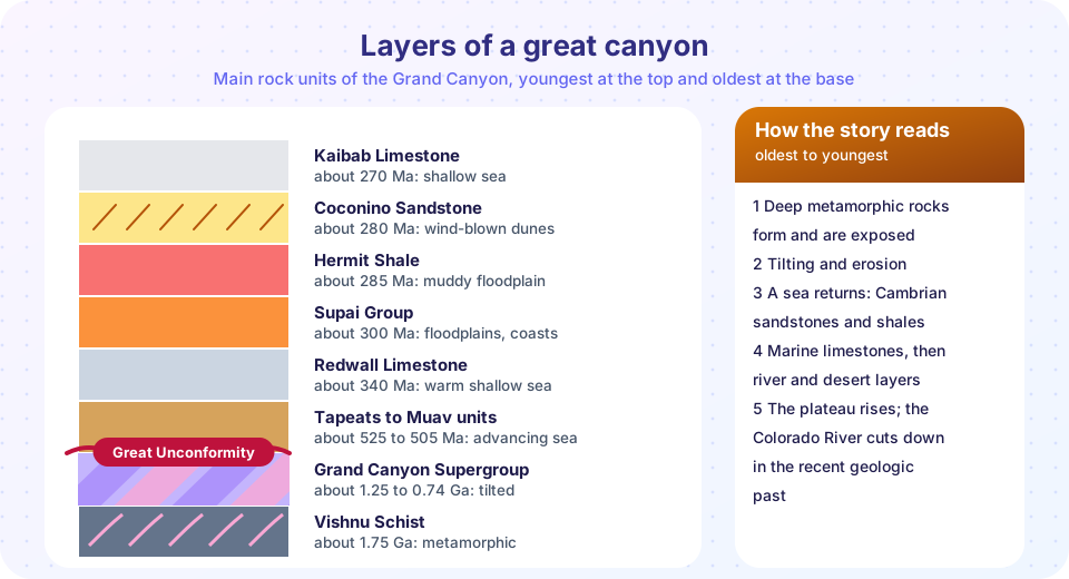
At the rim lies the Kaibab Limestone, about 270 million years old, full of marine fossils such as brachiopods, sponges and corals. It tells us that this high, dry plateau was once a shallow sea floor. Below it come layers that show the shoreline swinging back and forth.
The Coconino Sandstone, about 280 million years old, shows huge, steeply inclined sets of cross-bedding. Cross-bedding is what wind-blown dunes look like in section: sand avalanches down the slipface of each dune, leaving inclined layers. Fossil trackways of small animals preserved in the Coconino fit a desert environment. Below that the Hermit Shale and Supai Group, red from iron oxide, record muddy floodplains and coastal plains. Plants and footprints appear there too.
The Redwall Limestone, about 340 million years old, is a massive gray cliff that forms one of the most prominent bands in the canyon. It records a warm, clear sea with abundant marine life. Under it are thinner layers, then, at about 525 to 505 million years ago, the Tapeats Sandstone, Bright Angel Shale and Muav Limestone: a classic transgressive sequence, in which a rising sea first deposits sand at the shoreline, then mud in deeper water, then carbonate in clear water offshore. The sea advanced across the region from the west.
The Great Unconformity
Beneath the Tapeats Sandstone, the rocks are older by hundreds of millions to more than a billion years. In places the Tapeats rests directly on the Vishnu Schist, a metamorphic rock of about 1.75 billion years old; geologists call that contact a nonconformity. In other places it sits on the tilted layers of the Grand Canyon Supergroup, sedimentary and volcanic rocks about 1.25 to 0.74 billion years old, which gives an angular unconformity. Both together are the Great Unconformity.
The missing time can be calculated by subtracting the ages on either side:
gap = age of rock below − age of rock above
Vishnu Schist to Tapeats:  1,750 − 525 ≈ 1,225 million years
Supergroup to Tapeats:       740 − 525 ≈   215 million years
Over a billion years of history is absent at the first contact. During that time the old metamorphic rocks were uplifted, and any rocks laid on top were eroded away. The Supergroup is preserved only in down-dropped fault blocks, which tells you about the structure: the tilted layers are cut by ancient normal faults (Chapter 5), and the blocks were tilted before erosion planed the surface flat.
The basement
The Vishnu Schist and associated granites are the roots of an ancient mountain belt. A schist is a rock that formed deep in the crust under high temperature and pressure, with flaky minerals aligned by stress. For it to sit at the base of the canyon, kilometers of rock must have been removed: the Vishnu Schist is the best evidence of how much time and erosion that sits behind the unconformity. Its age comes from uranium-lead dating of zircon, as in Chapter 6.
Structure on a flat plateau
The plateau looks undeformed, but it has structures. The East Kaibab monocline is a single step in otherwise flat layers: beds dip steeply for a short distance and then flatten again. Monoclines often form when an old buried fault is reactivated, and the layers above drape over it. Several faults in the canyon cut Paleozoic layers and show offsets of tens to hundreds of meters. Reading them follows the rules you learned: a fault that cuts a layer is younger than the layer, and where layers on one side are higher than on the other, the fault's throw can be measured from the offset.
How old is the canyon, and how fast did the river cut?
The rocks are old, but the canyon is a much younger feature. The Colorado River carved it by cutting downward as the plateau was uplifted. The age of that carving is genuinely debated. A widely cited view is that the river reached something close to its present course and depth in about the last 5 to 6 million years. Other evidence has been argued to show that parts of an older canyon existed far earlier, perhaps tens of millions of years ago, and that the modern canyon is a combination of several segments.
Whichever view you take, the arithmetic is useful. If the river cut about 1,600 m down in 5.5 million years, the average incision rate is
rate = 1,600 m / 5,500,000 years ≈ 0.00029 m per year ≈ 0.29 mm per year
That is about the thickness of a few sheets of paper per year, a speed that is very slow but, over millions of years, enough to remove a vast volume. The river uses its sediment load as a cutting tool. Floods, rockfalls and debris flows from side canyons add boulders that make rapids.
Hazards in the canyon
The same rocks that make the scenery cause hazards. Cliff-forming layers undercut by weaker shale shed rockfalls. Side canyons funnel intense summer rain into flash floods and debris flows. Hikers are warned about heat, but the geologic risks are real too, which ties this case study back to Chapter 7: hazard times exposure times vulnerability.
Common misconceptions
"The river made the canyon in one place, so it is as old as the rocks." The rocks are far older than the canyon itself, which is a young erosional feature.
"A bigger gap in the record means more erosion." An unconformity records missing time. Some of it may be non-deposition rather than erosion.
"Horizontal layers mean nothing happened." Flat layers can sit above a surface that records enormous upheaval.
"The age of the canyon is settled." Most geologists agree on the rock ages but not on the timing of incision.
Try it
Press Run (or Ctrl + Enter) to see the result here.
Program input · what you'd type while the program runs
Type the answers before you press Run, one per line. Each time the program reads a line (with input()), it gets the next line from this box.
Press Run (or Ctrl + Enter) to see the result here.
Program input · what you'd type while the program runs
Type the answers before you press Run, one per line. Each time the program reads a line (with input()), it gets the next line from this box.
Press Run (or Ctrl + Enter) to see the console output here.
No output.
Check your understanding
Quick check · 5 questions
of 5 answered You scored / 5 · perfect!
-
1. The large, steeply inclined cross-beds in the Coconino Sandstone best support which environment?
Large, steeply inclined cross-beds are the signature of migrating sand dunes. -
2. Tapeats Sandstone (about 525 Ma) lies on Vishnu Schist (about 1,750 Ma). What is the approximate gap?
1,750 − 525 = 1,225 million years. -
3. Sedimentary rock directly on top of schist is a:
A nonconformity separates sedimentary rock from underlying metamorphic or igneous rock. -
4. If a river cut 1,000 m in 5 million years, the average rate is:
1,000,000 mm / 5,000,000 yr = 0.2 mm per year. -
5. Why do cliffs and slopes alternate in the canyon walls?
Resistant layers stand out as cliffs, weak layers form slopes.
Summary
- Read a column from the top down: each unit is a rock type, an environment and an age.
- Superposition works directly on near-horizontal layers; cross-bedding, fossils and rock types reveal ancient environments.
- The Great Unconformity hides hundreds to over a thousand million years, calculated by subtracting ages.
- The canyon is much younger than its rocks, and the timing of the river's cutting is debated.
- Hazards, rock strength and structure all connect to what you learned in earlier chapters.
Track your progress
Create a free account to tick off lessons and pick up where you left off on any device.
of Geology lessons completed