


















Lesson 40 of 48 · Field Methods and Maps
Strike, dip and geologic maps
Learn to measure and write strike and dip, solve the three-point problem, and read geologic maps: units, contacts, faults, folds and outcrop patterns.
A tilted rock layer is a plane, and to describe a plane in space you need two numbers. Geologists use strike and dip. With those two numbers, taken at many outcrops, you can draw the three-dimensional shape of folds and faults on a flat map. They are the most commonly recorded measurements in field geology, and every geologic map you will see is full of little T-shaped symbols that carry them.
This lesson defines strike and dip, shows how to write and measure them, uses them to solve a classic problem (finding the orientation of a bed from three drill holes) and then reads a whole geologic map. It builds directly on the faults and folds of Chapter 5.
What you will learn
- The definitions of strike, dip and dip direction, and how to write them.
- How to measure strike and dip with a compass-clinometer.
- How to find strike and dip from three points of known elevation.
- How to read geologic map colors, contacts, symbols and outcrop patterns.
Key terms
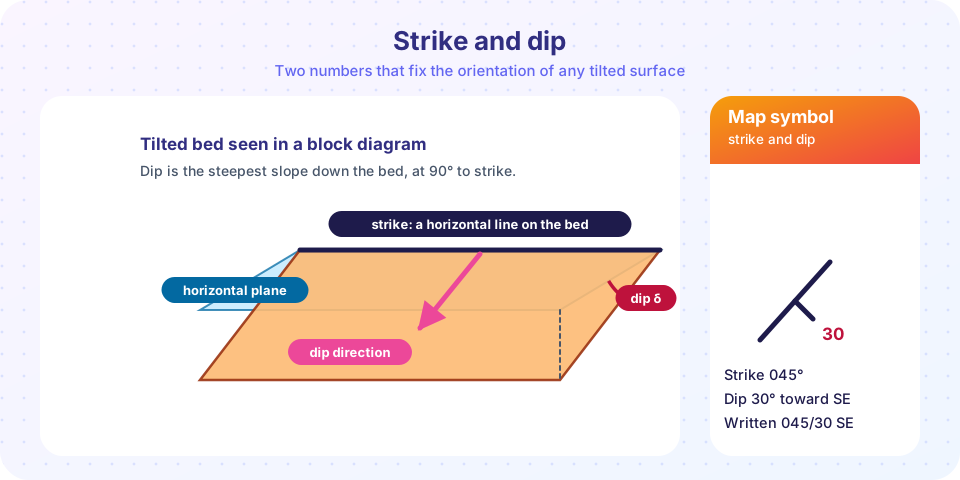
Strike is the compass direction (azimuth) of the line where an inclined plane meets a horizontal plane.
Dip is the angle between the inclined plane and the horizontal, measured down the steepest slope, at 90° to the strike.
Dip direction is the compass direction in which the plane slopes down.
Contact is the boundary between two rock units on a map.
Legend (map key) explains the colors, letters and symbols; units are listed from youngest at the top to oldest at the bottom.
Strike and dip
Imagine a tilted bed of sandstone sloping down into a lake. Where the water surface meets the bed, it traces a perfectly level line: that is the strike. At right angles to that line, running straight down the bed, is the direction a ball would roll: that is the dip direction. The angle that the bed makes with the water surface is the dip, between 0° (flat) and 90° (vertical).
Writing it down
Strike is given as an azimuth from 000° to 360° measured clockwise from north. Because a line has two directions (045° and 225° describe the same line), geologists use the right-hand rule: choose the strike direction such that the bed dips to your right as you look along it. Then dip direction is always strike plus 90°.
Two notations are common:
- Strike/dip with a compass direction:
045/30 SEmeans strike 045°, dip 30° toward the southeast. The letters guard against mistakes. - Dip direction/dip:
135/30gives the dip azimuth first, which needs no right-hand rule.
Older quadrant notation writes N45E, 30SE.
The map symbol
On a map a strike and dip is drawn as a long line (the strike) with a short tick pointing in the dip direction and the dip angle written beside the tick. A bed with dip = 0 is shown with a plus inside a circle, and a vertical bed with a line crossed by a short tick on both sides. Always check the legend.
Measuring in the field
A compass-clinometer (such as the Brunton) measures both numbers. To find strike, you hold the compass level against the bedding surface (or a notebook laid flat on it) and rotate it until the bubble is level and the edge follows a horizontal line; read the azimuth. For dip, turn the compass on its side with its long edge along the line of steepest descent and read the clinometer. Measure on a bed surface or a smooth plane, not a rough weathered one. A few readings are averaged. The compass reads magnetic north, so you must correct for declination, the angle between magnetic and true north in your area. It differs by place and drifts slowly with time.
The three-point problem
If you know the elevation of the same bed at three points, you can find its orientation. Three non-collinear points define a plane. This is exactly the problem for a petroleum geologist with three wells that penetrated the top of a reservoir at different depths.
Method on a map: take the highest point and the lowest point, and find where along the line joining them the elevation equals the middle point's elevation. Draw a line from that spot to the middle point: it is a line of equal elevation, so it is the strike. The dip follows from the elevation difference over the perpendicular distance: dip = arctan(Δz / d).
Method by calculation: fit a plane z = a x + b y + c. The gradient √(a² + b²) is the tangent of the dip, and the downhill direction is (−a, −b).
Example: the top of a bed is 300 m above sea level at point A (0, 0), 260 m at B (400 m east, 0) and 250 m at C (0, 300 m north). Then a = −0.1, b = −0.1667, the slope is √(0.01 + 0.0278) = 0.194, and the dip is arctan(0.194) ≈ 11°. The bed descends toward the east and north, so it dips northeast, about 031°. You will confirm this in the first TryIt.
Outcrop width and dip
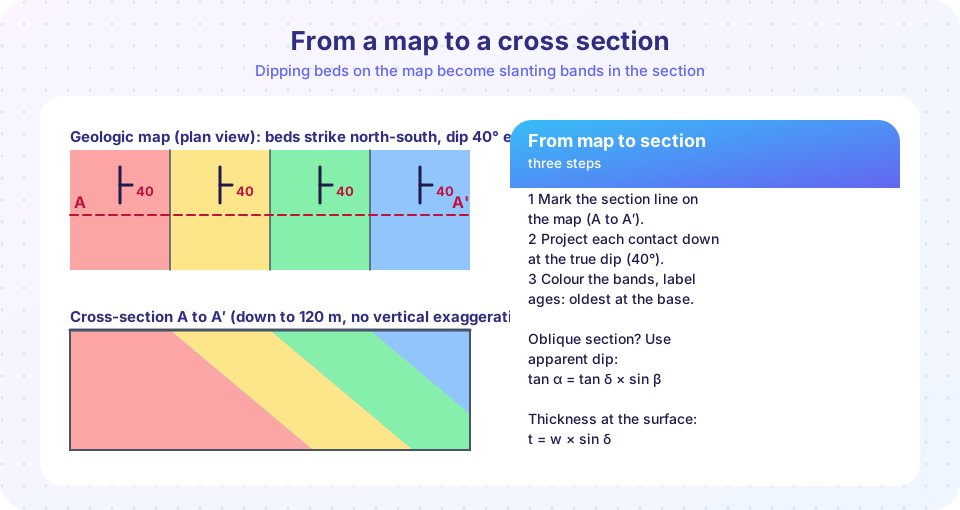
When a bed of true thickness t is cut by flat ground, the width w of its outcrop measured at right angles to strike is
w = t / sin δ
A 50 m thick bed dipping 5° produces an outcrop about 574 m wide. At 30° it is 100 m, and a vertical bed shows its true thickness of 50 m. On a map, wide bands of a unit usually mean gentle dips or thick beds, and narrow bands mean steep dips or thin beds. This is why vertical dikes and steep beds make thin lines.
Reading a geologic map
A geologic map is a topographic map (or a plain base map) colored by the rock units found at the surface.
- Colors and letters identify units. A letter code such as
Qalis Quaternary alluvium, andKdcould be a Cretaceous unit named for a type locality. The first letter is often the age. - Contacts are the boundaries between units. A solid line means the contact is observed, a dashed line is approximate, and a dotted line is concealed beneath cover.
- Faults are heavier lines. Small teeth on the upper plate mean a thrust (the teeth point in the direction of dip). A bar and ball on the downthrown side marks a normal fault. Paired half-arrows show strike-slip motion.
- Fold axes are marked with lines and arrows that show whether the fold is an anticline or a syncline and the direction of plunge.
- Strike and dip symbols show orientations at the points measured.
Outcrop patterns
The pattern a layer makes on the map depends on its dip and on the topography.
- Horizontal beds follow contour lines. Where a stream cuts a valley, the contact makes a branching, dendritic pattern.
- Vertical beds form straight lines that ignore topography.
- Dipping beds form V shapes where they cross valleys. In the usual case, when the beds dip more steeply than the stream flows, the V points in the direction of dip. This is the rule of Vs.
- Folds: in an eroded anticline, the oldest unit is in the center and the beds dip away from it; in a syncline, the youngest unit is in the center and the beds dip toward it. A plunging fold leaves a nose in the pattern.
- Faults offset contacts. A normal fault places younger rocks beside older ones on the downthrown side; a strike-slip fault shifts contacts sideways.
- Unconformities show up where younger units cut across the contacts of older units.
Common misconceptions
"Dip is the direction a bed tilts." Dip is an angle; the direction is the dip direction.
"Strike and dip can be measured on any surface." Use a flat bedding surface, not a rough or curved one.
"The map shows what is under the ground." It shows what is exposed at the surface; the rest is interpretation.
"A wide outcrop means a thick layer." Not necessarily; a gentle dip widens the outcrop.
Try it
Press Run (or Ctrl + Enter) to see the result here.
Program input · what you'd type while the program runs
Type the answers before you press Run, one per line. Each time the program reads a line (with input()), it gets the next line from this box.
Press Run (or Ctrl + Enter) to see the result here.
Program input · what you'd type while the program runs
Type the answers before you press Run, one per line. Each time the program reads a line (with input()), it gets the next line from this box.
Check your understanding
Quick check · 6 questions
of 6 answered You scored / 6 · perfect!
-
1. A bed has a strike of 090° and dips to the south. By the right-hand rule, the written orientation is:
Looking along 090° (east), south is to your right, so the dip is to the right. -
2. Dip is measured:
Dip is the maximum angle from horizontal, perpendicular to strike. -
3. A bed with strike 120° dips to the right of the strike direction. What is its dip direction?
Dip direction = strike + 90° = 210°. -
4. A 30 m thick bed dips 30° on flat ground. How wide is its outcrop?
w = t / sin 30° = 30 / 0.5 = 60 m. -
5. On a geologic map, a dotted contact line means:
Dotted lines show contacts hidden by soil, water or younger deposits. -
6. In an eroded anticline the oldest unit is:
Erosion exposes the oldest rock in the core of an anticline.
Summary
- Strike is the azimuth of a horizontal line on a bed; dip is the steepest tilt angle, at 90° to strike; dip direction is strike plus 90° (right-hand rule).
- Write orientation as
045/30 SEor as dip direction/dip,135/30. - Three elevations define a plane, giving strike and dip.
- Outcrop width is
t / sin δ, so gentle dips make wide outcrops. - Geologic maps use colors, letter codes, contacts, fault symbols and dip symbols; the rule of Vs and fold patterns reveal structure.
Track your progress
Create a free account to tick off lessons and pick up where you left off on any device.
of Geology lessons completed