


















Lesson 34 of 46 · Sustainable and Urban Architecture
City form: streets, blocks and density
Learn how street width, block size, plot coverage and floor area ratio shape cities, with famous plans, density calculations and the idea of the walkable neighborhood.
Pick any city you know and imagine looking down on it from an aircraft. You would see patterns: a regular grid of streets in one district, a tangle of curving lanes in another, wide boulevards, small squares, blocks of buildings around courtyards, towers standing in open space. These patterns are not accidents. They come from decisions that architects, planners, surveyors and landowners made over decades or centuries, and they decide how it feels to live there: how far you walk to a shop, how much sun reaches a street, how safe a pavement feels at night, how much energy a neighborhood needs.
Urban form is the study of that physical structure. This lesson introduces its basic elements (streets, blocks and plots), the measures planners use to describe density, and a few famous plans that show different ideas of the city.
What you will learn
- The elements of urban form: streets, blocks, plots, buildings, open space
- How to measure density with plot coverage, floor area ratio and dwellings per hectare
- How street proportions affect sunlight and enclosure
- Four classic ideas of the city and what each got right and wrong
- What makes a neighborhood walkable and why it matters for sustainability
Key terms
Plot (lot): a piece of land under one ownership on which a building stands.
Block: an area of plots surrounded by streets.
Plot coverage: the percentage of a plot occupied by the building's footprint.
Floor area ratio (FAR): the total floor area of a building divided by the area of its plot.
Mixed use: a mix of homes, shops, workplaces and services in the same neighborhood or building.
The elements of a city
The smallest unit is the plot. Plots are grouped into blocks, which are bounded by streets. Streets connect to other streets in a network, and the network decides how easy it is to move. Between buildings there is open space: gardens, courtyards, squares and parks. Together, these produce the "grain" of a city. A fine grain, with small blocks and many street connections, offers many routes and a lively street life. A coarse grain, with huge blocks and few connections, favors cars and makes walking long.
Typical block sizes illustrate this. The blocks of the Eixample in Barcelona, laid out from the plan of Ildefons Cerdà in 1859, are about 113 meters on a side with chamfered corners, giving small intersections with good visibility. A long block of 400 meters, as found in some modern developments, forces pedestrians to walk much farther to reach the next street.
Measuring density
Density is simply "how much stuff per area", but there are several ways to measure it, and they tell different stories.
- Plot coverage =
footprint area / plot area. A building that covers 40 percent of a plot leaves 60 percent as garden, courtyard or parking. - Floor area ratio (FAR) =
total floor area / plot area. A FAR of 2.0 on a 1,000 m2 plot allows 2,000 m2 of floors. How those floors are arranged is up to the designer. - Dwellings per hectare counts homes, where 1 hectare is 10,000 m2. Detached suburbs may reach 15 to 30; terraced streets 40 to 80; mid-rise blocks 100 to 200 and more; towers can exceed 300.
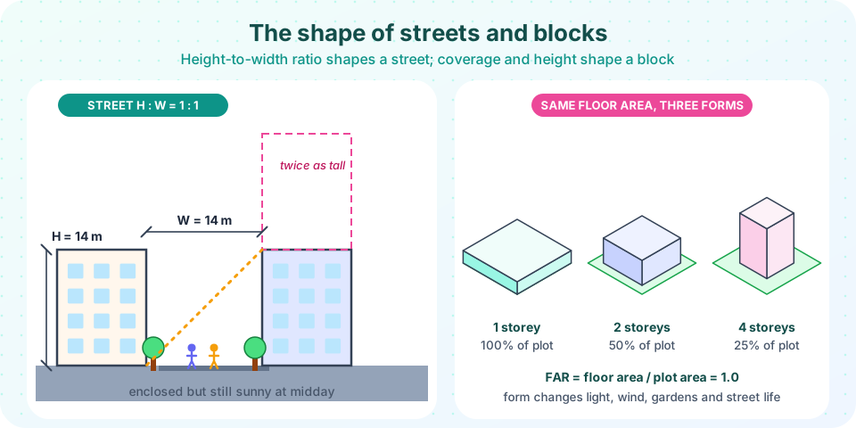
The drawing above shows why you need more than one number. Take a plot of 1,000 m2 and a FAR of 1.0. You can cover the whole plot with a single-storey building (coverage 100 percent), build two storeys on half of it, or four storeys on a quarter of it. Each has the same floor area, but the open space, the daylight reaching the ground, the views and the shadows differ completely. This is why codes often combine limits on height, coverage and FAR.
Worked example. A plot is 40 m by 25 m = 1,000 m2. The code allows FAR 2.4 and coverage up to 60 percent. Maximum floor area: 2.4 x 1000 = 2,400 m2. Maximum footprint: 0.6 x 1000 = 600 m2. Number of full storeys at maximum coverage: 2400 / 600 = 4.
Street proportions
Streets are rooms without roofs, and their shape is described by the ratio of building height (H) to street width (W). At H:W = 1:1, a person on the pavement feels enclosed but comfortable, and the sun reaches the pavement at midday when its altitude is above 45 degrees. At 2:1 (a canyon), the street feels tall and gets little direct light, which suits hot climates where shade is welcome. At 1:4, a wide boulevard, the space feels open and may feel empty without trees.
The sun angle ties this to the previous chapter. If the buildings on both sides are 14 m tall and the street is 14 m wide, a ray from the top of one building reaches the foot of the opposite building at 45 degrees. Any solar altitude above that lights part of the pavement; any below leaves it in shade. Streets in northern climates need lower ratios to stay sunny in winter, and streets in hot deserts, like the narrow lanes of old Marrakech or Yazd, use high ratios to stay cool.
Four ideas of the city
- The grid. The Commissioners' Plan of 1811 for Manhattan laid out a rectangular grid of long blocks. Grids are easy to survey, divide and extend, and are easy to navigate, but they treat every site alike regardless of topography, and long blocks can be coarse in grain.
- The garden city. Ebenezer Howard's 1898 book proposed self-contained towns of limited size ringed by a green belt, with homes, industry and farmland together. Letchworth and Welwyn in England followed. It inspired suburbs worldwide, but low density can make people dependent on cars.
- The radiant city. Le Corbusier's 1920s and 1930s plans proposed tall towers set in parkland, with roads separated from homes. It promised light and air, and inspired many post-war housing estates. Critics found that wide open spaces without street life could feel empty and unsafe.
- The lively street. In The Death and Life of Great American Cities (1961), the writer and activist Jane Jacobs defended short blocks, mixed uses, old buildings and "eyes on the street" (people watching from windows and shops), arguing that these create safe, lively places. Her ideas shaped modern urban design.
Each of these ideas holds a truth, and modern planning mixes them: grid-like connections, green space, light and air, and street life.
Walkable neighborhoods
A neighborhood is walkable when the things people need daily (shops, school, park, a transit stop) are within a short walk, commonly taken as about 400 to 800 meters, or 5 to 10 minutes. The recent "15-minute city" idea, developed by the researcher Carlos Moreno and adopted in cities such as Paris, extends this: most daily needs should be within 15 minutes on foot or by bicycle.
Walkability matters for sustainability because transport is a major source of carbon emissions and because walking and cycling are healthy and cheap. It depends on form: mixed use (so that destinations are nearby), connected streets (so that routes are short), safe and shaded pavements, active frontages (shopfronts and doors instead of blank walls) and sufficient density to support local shops and frequent public transport. Transit-oriented development concentrates homes and jobs near stations for the same reason.
Common misconceptions
"Density means towers." A terraced street or a courtyard block can house more people per hectare than a lot of tower estates, because towers need open space around them.
"Low density is greener." A large garden helps biodiversity, but low density increases the length of roads, pipes and trips, and usually the carbon per person.
"Any density works if the building is efficient." Good density needs services, green space, daylight and good streets; overcrowding fails by every measure.
"A grid is always better than curved streets." Grids make routes short and flexible; curved layouts can fit a slope, calm traffic and create views. The question is whether the network is connected.
Try it
First, a calculator for the plot example and for dwellings per hectare. Change the plot size, FAR and coverage and see how many storeys fit.
Press Run (or Ctrl + Enter) to see the result here.
Program input · what you'd type while the program runs
Type the answers before you press Run, one per line. Each time the program reads a line (with input()), it gets the next line from this box.
Second, a massing explorer. Choose the coverage and see the number of storeys needed for a fixed FAR, with a simple side view of the block against a standing figure.
Check your understanding
Quick check · 5 questions
of 5 answered You scored / 5 · perfect!
-
1. A plot is 2,000 m2 and the allowed FAR is 1.5. What is the maximum total floor area?
FAR x plot area = 1.5 x 2000 = 3000 m2. -
2. Streets 20 m wide are lined by buildings 20 m tall. What is H:W?
H / W = 20 / 20 = 1. -
3. Which idea is associated with 'eyes on the street'?
Jacobs argued that mixed uses and overlooked streets make them safe and lively. -
4. Which feature most strongly supports walkability?
Short routes, destinations nearby and comfortable pavements make walking easy. -
5. Four storeys cover 25 percent of a plot. What is the FAR?
FAR = coverage x storeys = 0.25 x 4 = 1.0.
Summary
- Cities are made of plots, blocks, streets and open space; fine grain and connectivity favor walking.
- Plot coverage, FAR and dwellings per hectare measure density from different angles; FAR = coverage x storeys.
- Street proportion H:W shapes sunlight and enclosure; sun altitude determines when a pavement is lit.
- The grid, garden city, radiant city and lively-street ideas each offer a lesson.
- Walkable neighborhoods need mixed use, connected and safe streets and enough density.
Next: Reuse and heritage
Track your progress
Create a free account to tick off lessons and pick up where you left off on any device.
of Introduction to Architecture lessons completed