


















Lesson 17 of 43 · Transportation and Mobility
Streets for People
Learn what a street is for, how vehicle speed decides who survives a crash, what complete streets and traffic calming do, and how to read a street cross-section.
A street is the most common public space in any city. It is where people walk, meet, shop, wait for the bus, deliver goods and, yes, drive. Yet for most of the twentieth century, many streets were designed as if their only job were to move cars. The result was wide, fast roads that were dangerous to cross and unpleasant to linger on. This lesson shows how planners rethink streets as places for everyone, using design, speed and the division of space.
You will learn why speed matters so much to safety, how to read a street cross-section, and which tools, from a simple painted crossing to a full redesign, turn a road into a complete street.
What you will learn
- The two jobs of a street: movement and place.
- How vehicle speed affects crash outcomes, with a plot.
- What complete streets, traffic calming and Vision Zero mean.
- How to read a cross-section and allocate space between modes.
Key terms
Right-of-way: the strip of public land from building edge to building edge, which holds the street.
Complete street: a street designed to be safe and usable for all users, including people walking, cycling, using transit and driving.
Traffic calming: design measures that slow traffic, such as speed humps, narrowed lanes or roundabouts.
Design speed: the speed a street is designed for, which sets how drivers behave.
Vision Zero: a policy goal of eliminating traffic deaths and serious injuries, which started in Sweden in 1997.
Movement and place
Planners often describe a street as having two functions: movement (getting people and goods from A to B) and place (being somewhere to be: a shopping street, a square, a front yard). Different streets weigh these differently. A motorway is nearly all movement. A village high street is mostly place. Most city streets are both, and conflicts arise when a street that should be a place is designed only for movement.
This movement-and-place idea is used in London's street types framework and in many other cities. It prompts the right question: what is this street for, and who is it for? Answering that decides how much space to give to each user.
Speed and survival
The single most important design variable for safety is vehicle speed. Physics is merciless: the energy of a moving vehicle grows with the square of its speed, so doubling speed quadruples the energy a crash must dissipate. Studies of crash data, for example an analysis by Brian Tefft for the AAA Foundation published in 2013, estimate the risk that a pedestrian struck by a car suffers severe injury. The risk rises steeply with speed: roughly 10 percent at about 25 km/h (16 mph), 25 percent at about 37 km/h, 50 percent at about 50 km/h (31 mph), 75 percent at about 63 km/h and 90 percent at about 74 km/h. The exact numbers depend on the vehicle, the person's age and many other factors, but the shape of the curve is consistent across studies: small speed reductions in the range of 30 to 50 km/h bring large safety gains.
This is why many cities set 30 km/h (or 20 mph) limits on residential and central streets, and why design matters more than signs. A wide, straight street with long sightlines invites drivers to go fast regardless of the posted limit. Narrow lanes, planted islands, raised crossings and tight corner radii make high speeds feel uncomfortable, so drivers slow down.
Vision Zero and the safe system
In 1997 the Swedish parliament adopted Vision Zero, a policy that no one should be killed or seriously injured in traffic and that the system, not the individual road user, bears primary responsibility for safety. Humans make mistakes, so streets should be designed so that mistakes are not fatal. Many cities have adopted versions of the idea since. The approach moves attention from blaming road users to engineering lower speeds, separation of users and safer intersections.
Tools for better streets
Sidewalks and crossings. A continuous, wide, level sidewalk with frequent, safe crossings is the foundation. Raised crossings and curb extensions shorten crossing distance and slow turning cars.
Protected bike lanes. Painted lanes beside fast traffic attract few riders. Physically separated lanes, with curbs, planters or parked cars as a barrier, make cycling feel safe to a much wider range of people. Cities that built connected networks, such as Copenhagen and Utrecht, saw cycling rise strongly.
Transit priority. Dedicated bus lanes and signal priority speed buses, making them a more attractive choice (see the next lesson).
Traffic calming. Speed humps, chicanes, mini-roundabouts and narrowed lanes slow vehicles. A related Dutch idea is the woonerf (living street), developed in the 1970s, in which cars, pedestrians and cyclists share a street at walking pace.
Road diets. Reducing the number or width of general traffic lanes, often converting a four-lane road into two lanes plus a center turn lane and bike lanes, can cut crashes without significantly reducing capacity on many streets with moderate traffic.
Trees and furniture. Street trees shade, cool and calm traffic. Benches, lights and active building frontages turn a corridor into a place.
Superblocks. Barcelona began creating "superblocks" in 2016: groups of city blocks in which through traffic is kept to the perimeter and the inner streets become calm, shared spaces with priority for people.
Reading a cross-section
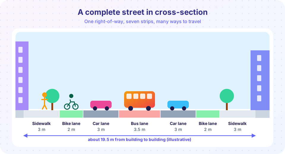
A cross-section is a slice across the street from one building line to the other. The picture at the start of this lesson shows seven strips: two sidewalks, two bike lanes, two general traffic lanes and a central bus lane. Typical widths, which vary by context, are:
| Element | Typical width |
|---|---|
| Sidewalk (clear walking zone) | 2 to 3 m, wider in busy areas |
| Protected bike lane (one way) | 1.5 to 2 m |
| General traffic lane | 2.7 to 3.3 m |
| Bus lane | 3.0 to 3.5 m |
| Parking lane | 2.2 to 2.5 m |
The street has a fixed total width, so giving more to one use means taking from another. This is why planners call street design a question of allocation. Narrower traffic lanes, for example, do not reduce safety and can reduce speeds, freeing space for walking and cycling.
Levels of service and a different measure of success
For decades, traffic engineers used level of service (LOS), a grade from A (free flow) to F (breakdown) assigned to the delay faced by cars, as the main measure of a street's success. A street that dropped to LOS D at peak hour was considered a problem to fix by adding lanes. Critics argue that LOS counts only vehicles and ignores the people who walk, cycle or shop, and that it encourages ever-wider roads. Many places now use measures such as total person throughput, safety, vehicle-kilometers traveled or the quality of walking and cycling conditions.
Common misconceptions
"Wider lanes are safer." Evidence generally shows that wide lanes encourage higher speeds, and that lanes of about 3 meters are adequate for most urban streets.
"Bike lanes take away space from traffic for no reason." They carry people on bikes, reduce crashes when well designed and can use space more efficiently than a general lane at peak times.
"Speed limits alone make streets safe." The design of the street, its width, curves, crossings and edges, decides the speeds drivers actually choose.
Try it
First, plot the relationship between impact speed and the risk of severe injury for a pedestrian. The points come from a published analysis of crash data (Tefft, 2013), which we use with rounding. The line connects them to show the shape of the curve.
Press Run (or Ctrl + Enter) to see the result here.
Program input · what you'd type while the program runs
Type the answers before you press Run, one per line. Each time the program reads a line (with input()), it gets the next line from this box.
Second, a street-space allocator. You have a 19.5 m right-of-way (building to building). Drag the sliders to divide it, and check each strip against a minimum comfortable width.
Check your understanding
Quick check · 5 questions
of 5 answered You scored / 5 · perfect!
-
1. What does Vision Zero, adopted in Sweden in 1997, aim for?
Vision Zero treats deaths and serious injuries as preventable and puts responsibility on the design of the system. -
2. If a car doubles its speed, its kinetic energy:
Kinetic energy is proportional to speed squared, so doubling speed gives four times the energy. -
3. A road diet typically:
Converting for example a four-lane road to two lanes plus a turn lane and bike lanes is a classic road diet. -
4. Which describes the two functions of a street?
Planners balance movement (getting somewhere) and place (being somewhere). -
5. Which criticism is made of level of service (LOS)?
LOS grades vehicle delay and ignores the people who walk, cycle or shop on the street.
Summary
- Streets have two jobs, movement and place, and design should reflect which matters most.
- Speed is the key variable for safety; the risk of severe injury climbs steeply above about 30 km/h.
- Complete streets use sidewalks, protected bike lanes, transit priority, traffic calming and trees; Vision Zero puts responsibility on system design.
- A cross-section shows a fixed width being allocated, so planners trade space between users.
Next: Public Transit
Track your progress
Create a free account to tick off lessons and pick up where you left off on any device.
of Urban Planning lessons completed