


















Lesson 3 of 43 · Getting Started
Scales, Tools and Actors
See how planning works from region to parcel, which tools planners use, who the key actors are and how power is shared in different planning systems.
A planner who changes a bus route and a planner who writes the rules for one lot are both doing planning, yet their daily work looks very different. One thinks in tens of kilometers and millions of trips, the other in meters and building permits. Understanding the scales at which planning works, the tools it uses and the people who shape the outcome gives you a map of the whole field.
This lesson walks from the largest scale to the smallest, lists the main planning tools, introduces the cast of characters, and ends with a comparison of how different countries share power over land.
What you will learn
- The scales of planning and what each one decides.
- The main planning tools, from plans to taxes.
- Who the actors are and how they influence each other.
- How planning systems differ between countries.
Key terms
Jurisdiction: the area and level of government that has legal authority over a decision.
Subdivision: dividing land into lots and streets; subdivision rules say how.
Capital improvement plan: a multi-year list of public construction projects with a budget.
Right-of-way: land reserved for public use, such as a street or rail line.
Entitlement: legal permission to build or use land in a particular way.
The scales of planning
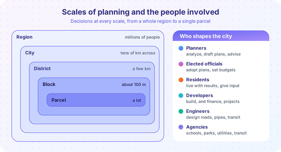
Planning decisions nest like boxes inside boxes.
Region. A region is a city plus its commuting area, which may contain dozens of local governments. Regional planning handles things that cross borders: highways and rail lines, river basins, airports, and the broad pattern of growth. Because a region seldom has a single government, regional planning often works by agreement and by money: a regional body might control transport funding even though it cannot write local rules.
City. The city scale is where most planning law applies. A city adopts a comprehensive plan, a zoning map, a budget and a program of public works. Decisions here set the size and shape of the whole urban area.
District or corridor. A district may be a downtown, a university quarter or a rail corridor of a few kilometers. District plans, sometimes called area plans or specific plans, are more detailed than the citywide plan and are used to guide a change, such as redeveloping an old port.
Neighborhood and block. At this scale planners look at streets, sidewalks, parks, schools and the mix of homes and shops. A typical city block in many grids is about 80 to 150 meters on a side, and the block is a useful unit for studying how a street feels to walk along.
Parcel. A parcel, or lot, is a single piece of land with one owner. Here the work is concrete: what may be built, how tall, how far from the boundary, how many parking spaces. Most day-to-day planning decisions, such as approving a building permit, happen at the parcel scale.
Good planning connects the scales. A regional decision to build a rail line only works if the city allows homes near stations, the district plan makes them walkable, and the parcel rules let buildings face the street.
The planning toolkit
Planners rarely build anything themselves. They guide others using a set of tools.
| Tool | What it does | Example |
|---|---|---|
| Comprehensive plan | Sets a long-term vision and policies | "Direct growth to areas with transit" |
| Zoning ordinance | Sets what may be built where | A district allows buildings up to 15 m |
| Subdivision regulations | Controls how land is split into lots and streets | Minimum street width, lot size |
| Capital improvement plan | Schedules public projects and spending | A new library in year three |
| Design guidelines | Shapes how buildings look and relate to the street | Entrances must face the sidewalk |
| Incentives and fees | Rewards or charges to steer private choices | Extra height allowed if affordable homes are included |
| Taxes | Changes the cost of holding or developing land | A tax on vacant land |
| Direct provision | The public sector builds | Parks, schools, transit lines |
Notice the mix of regulation (you must), incentive (you may, and here is a reward) and provision (we will build it). Most plans combine all three, because regulation alone can prevent bad outcomes but cannot, by itself, produce a good park or a bus line.
The actors
Many people shape what is finally built.
- Planners collect data, write plans, advise officials and run the public process. They usually do not make the final decision.
- Elected officials, such as city councillors or a mayor, adopt plans, approve budgets and sometimes rule on specific projects. They answer to voters.
- Residents and community groups live with the results. They can speak at hearings, vote, organize, and in some systems appeal decisions.
- Developers and landowners propose and finance buildings. They know costs and markets, and they want to earn a return.
- Engineers and transport agencies design and operate roads, water, sewers and transit, and set many technical standards.
- Public agencies run schools, parks, utilities, housing programs and emergency services. Their needs must be matched with land.
- Higher levels of government set the rules local governments work under: national planning law, environmental standards, funding programs.
Planners often use a power and interest grid to think about this cast: stakeholders with high power and high interest are managed closely, those with high power but low interest are kept informed, and those with high interest but little power may need extra effort to be heard. It is a simple but useful way to ask whose voice might be missing from a process.
Different systems, different rules
The same word, "planning," covers very different legal systems.
- United States. Land-use control is largely a local power, exercised under what lawyers call the police power to protect health, safety and welfare. Zoning is the main tool, and a project that meets the rules is generally allowed "as of right." States set the framework, and the federal government influences planning mostly through money and environmental law.
- England. Since the Town and Country Planning Act 1947, development rights have been controlled by the state: almost any significant change requires planning permission, and decisions are made case by case against a plan, which gives officials more discretion.
- Japan. National law sets a fixed menu of zoning categories that every city uses, so the rules for a given district type are nearly the same across the country.
- The Netherlands. Planning has a long tradition of public land ownership and coordinated national, regional and municipal plans, which is one reason Dutch cities have been able to coordinate housing and transport tightly.
- Many fast-growing cities. Plans may exist on paper while much of the city grows informally. Planners there often focus on upgrading informal settlements and reserving land for future roads and utilities.
Each approach has strengths and weaknesses. Rules-based systems offer predictability for builders but can be rigid. Discretionary systems are flexible but slower and less predictable. No system is best everywhere, and countries borrow ideas from one another.
Common misconceptions
"The city planning department controls everything built in the city." It controls what the law gives it authority over. Roads may belong to a transport agency, schools to a school board, a university to its own board, and some land to national or state governments.
"A plan is a law." A comprehensive plan is a policy document in some places and a binding legal instrument in others. Zoning, by contrast, is a regulation with legal force. Check which applies where you live.
"Public participation means everyone gets what they want." Participation gives people a voice and shapes decisions, but it cannot satisfy conflicting wishes at once. Someone usually has to decide.
Try it
The first widget presents short scenarios and asks which actor mainly makes the decision. It is a teaching simplification, since real decisions are shared.
The second example sorts stakeholders on the power and interest grid. The numbers are invented for a made-up bus-lane project.
Press Run (or Ctrl + Enter) to see the result here.
Program input · what you'd type while the program runs
Type the answers before you press Run, one per line. Each time the program reads a line (with input()), it gets the next line from this box.
Check your understanding
Quick check · 5 questions
of 5 answered You scored / 5 · perfect!
-
1. Which scale is the most natural place to plan a new rail corridor that crosses several municipalities?
Regional planning handles networks and decisions that cross local government borders, such as rail lines, highways and river basins. -
2. A city offers extra building height in return for affordable homes. Which kind of planning tool is this?
An incentive offers a reward for a desired outcome instead of simply requiring it. -
3. Under England's Town and Country Planning Act 1947, development rights are mostly:
England uses a discretionary system in which most significant development needs permission, judged against a plan. -
4. On a power and interest grid, which group needs extra effort to be heard?
People with a strong stake but little power, such as daily riders or renters, may be missed unless the process is designed to reach them. -
5. Which statement about a comprehensive plan is most accurate?
Comprehensive plans set policy for the future. Whether they are binding depends on the legal system.
Summary
- Planning works at nested scales: region, city, district, block and parcel, and good plans connect them.
- The main tools are plans, zoning, subdivision rules, capital programs, design guidelines, incentives, taxes and direct provision.
- Planners advise; elected officials, developers, engineers, agencies and residents all shape results.
- Planning systems differ: rules-based, discretionary, national-menu and publicly coordinated models each have trade-offs.
Track your progress
Create a free account to tick off lessons and pick up where you left off on any device.
of Urban Planning lessons completed