


















Lesson 7 of 43 · History of Cities
Ancient and Medieval Cities
Explore how early cities, Greek and Roman grid towns, Chinese capitals and medieval market towns were laid out, and what their plans can still teach planners.
For most of human history there were no cities at all. Then, between roughly 4000 and 3000 BCE in southern Mesopotamia, villages grew into places with thousands of people, temples, specialized crafts, written records and rulers. Uruk, in what is now Iraq, is the best-known early example. From then on, a handful of urban traditions arose around the world, each with its own answer to the question of how to arrange a place where strangers live close together.
This lesson tours those traditions: the planned cities of the Indus valley, the grid towns of Greece and Rome, the walled capitals of China, the organic market towns of medieval Europe and the courtyard cities of the Islamic world. The point is not to memorize dates but to notice which design choices recur and why.
What you will learn
- Why early cities appeared and what they needed to function.
- How the Greek and Roman grid worked and how it spread.
- How medieval market towns and other traditions took shape.
- What planned and organic cities each do well.
Key terms
Grid plan: a street layout of straight, parallel and perpendicular streets, also called a rectilinear plan.
Agora and forum: the central public space of a Greek and a Roman city, used for markets, politics and meeting.
Cardo and decumanus: the north-south and east-west main streets of a Roman town.
Charter: a legal document granting a medieval town self-government and trading rights.
Citadel: a fortified part of a city, often on high ground.
Why cities appeared
Cities need a farming surplus, because many residents do not grow their own food. They need ways to store grain, organize labor, settle disputes and record debts. Early cities clustered where rivers gave fertile soil and transport: the Tigris and Euphrates, the Nile, the Indus and the Yellow River. Walls, temples, granaries and canals were their early public works.
Seen this way, a city is a technology for trade and cooperation. Everything planners do later, from water supply to markets, is a refinement of what those first cities had to solve: how to feed people, move goods, keep order and protect themselves.
The Indus valley: order and drainage
The cities of the Indus civilization, notably Harappa and Mohenjo-daro in present-day Pakistan, flourished around 2600 to 1900 BCE. Excavations show streets laid out on a rough grid, standardized fired bricks, and an impressive drainage system with covered drains running along the streets and from many houses. Many houses had their own wells or bathing rooms. Scholars still debate who governed these cities, since no palaces or clear royal tombs have been found and the script remains undeciphered, but the consistent layout and sanitation suggest strong collective organization.
Greek grids and the Roman standard
Greek colonies of the fifth century BCE and later often used regular grids. The architect and theorist Hippodamus of Miletus is traditionally credited with introducing grid planning to Greek cities and is linked with the rebuilding of the port of Piraeus. Aristotle later criticized his ideas in the Politics. We should be careful: grid planning in Greece did not begin with one man, and the "Hippodamian plan" is better understood as a regular layout in which equal plots are allocated to colonists. The attraction was fairness and speed: a founder could mark out a town and give every household a similar plot.
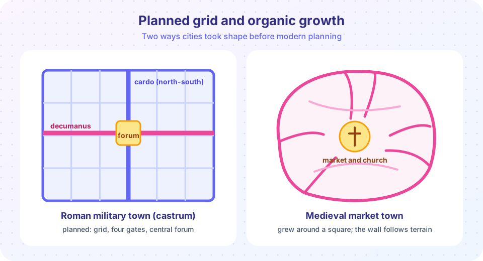
The Romans turned the grid into a standard. A typical new town, or castrum (a camp), was laid out on a rectangle with two main streets: the cardo, running roughly north to south, and the decumanus, running east to west. They crossed near the forum, the civic heart. Smaller streets divided the town into blocks called insulae, and the whole was enclosed by a wall with gates where the main streets met it. Many modern European cities, including Turin, Cologne and parts of London and Paris, still follow outlines first set by Roman planners. The town of Timgad in Algeria, founded around 100 CE, is a famously clear surviving example.
Roman engineers added infrastructure on a grand scale: aqueducts bringing water from distant springs, sewers such as Rome's Cloaca Maxima, paved roads, public baths and amphitheaters. The Roman writer Vitruvius, in his Ten Books on Architecture (first century BCE), gave advice on choosing a healthy site, attending to winds and water, and laying out streets, an early piece of planning guidance.
Chinese capitals: cosmic order on a grid
In China, a text called the Kaogongji (Record of Trades), from the late first millennium BCE, describes an ideal capital: a square enclosure with gates, a grid of avenues and the palace placed centrally or to the north. Real cities did not always follow the ideal, but the Tang capital Chang'an (modern Xi'an), at its height in the eighth century CE one of the largest cities in the world, was laid out on a strict grid of wide avenues dividing the city into walled wards with controlled gates. The plan expressed order, hierarchy and the ruler's authority. Later, Japanese cities such as Heijo-kyo (Nara) and Heian-kyo (Kyoto) adopted similar grids.
The medieval market town
After the fall of the Western Roman Empire, many European cities shrank, but from about the eleventh century trade revived and towns grew again. A medieval town typically had a market square, a church or cathedral, a wall and gates, and a tangle of lanes that followed older paths, the contours of the land and property boundaries. Streets were narrow, which gave shade and shelter and suited the pedestrians and carts of the time. Trades often clustered by street, still visible in old street names such as Tanners' Street or Goldsmiths' Row.
Towns won charters that granted rights to hold markets, collect tolls and govern themselves. This is an early form of municipal autonomy, and it is one reason European city governments have a long tradition of local power.
Not all medieval towns were organic. In southwest France and elsewhere, rulers founded bastides, new towns on a regular grid around a central square, in the thirteenth and fourteenth centuries to attract settlers and secure territory. Planned and unplanned forms coexisted.
Other traditions
Elsewhere other models developed. Many cities of the Islamic world, such as old Fez, Cairo and Damascus, are dense, with houses built around inward-facing courtyards, narrow shaded lanes that sometimes end in dead ends serving a cluster of homes, and a central bazaar (souk) and congregational mosque. In Mesoamerica, the great city of Teotihuacan, near present-day Mexico City, was laid out on a grid aligned to a grand central avenue lined with temples and pyramids, at its peak in the first half of the first millennium CE. West African trading towns, such as Djenné, combined earth architecture with market and mosque centers. These examples show that there is no single universal city form, only responses to climate, culture, religion and economy.
What we can learn
- Planned layouts are fast and fair. A grid is easy to survey and extend, and it makes land division simple.
- Organic layouts are adaptable. They respond to terrain and tend to produce intimate, varied streets.
- Infrastructure comes first, or comes late with consequences. Cities that planned drains and water (Indus, Rome) were healthier than those that did not.
- Public space is the common thread. Agora, forum, square, bazaar: every tradition set aside a place for exchange and gathering.
Common misconceptions
"Planning was invented in the twentieth century." Deliberate layouts and public works are thousands of years old. What is modern is the profession, the legal framework and the use of data.
"Medieval towns were all chaotic." Many grew organically, but others, like bastides, were planned, and even organic towns followed rules about markets, building lines and fire.
"A grid always means central control." Grids were used by empires and by colonists seeking fair shares. They were also easy to extend by merchants and city builders, so they appear in very different political systems.
Try it
The first example generates a Roman-style grid and counts its blocks and street length. It is a simple geometric model.
The second example uses a Monte Carlo experiment to measure how much longer a trip is on a grid than in a straight line. It is a fun fact with a real mathematical answer.
Press Run (or Ctrl + Enter) to see the result here.
Program input · what you'd type while the program runs
Type the answers before you press Run, one per line. Each time the program reads a line (with input()), it gets the next line from this box.
Check your understanding
Quick check · 4 questions
of 4 answered You scored / 4 · perfect!
-
1. In a Roman camp town, what were the two main streets called?
The cardo ran roughly north to south and the decumanus east to west; they met near the forum. -
2. Which Indus valley feature is most striking to historians of urban planning?
Harappa and Mohenjo-daro show consistent street layouts and extensive drainage. No clear royal palaces have been found. -
3. What is a bastide?
Bastides were new towns planned on a regular grid around a central square in the 13th and 14th centuries. -
4. The average grid route is about how much longer than a straight line (for randomly oriented trips)?
The average ratio of |dx|+|dy| to the straight-line distance over random directions is 4/pi, about 1.27.
Summary
- Early cities arose where farming surplus, rivers and trade allowed dense settlement, and they needed storage, water and rules.
- The Indus cities, the Greek and Roman grid towns and Chinese capitals show deliberate, geometric planning thousands of years ago.
- Medieval market towns mixed organic growth with planned examples such as bastides, and won charters of self-government.
- Planned grids offer speed and fairness; organic towns offer adaptability and character; every tradition set aside public space.
Track your progress
Create a free account to tick off lessons and pick up where you left off on any device.
of Urban Planning lessons completed