


















Lesson 14 of 43 · Land Use and Zoning
Mixed Use and Transit-Oriented Development
Learn why planners mix uses, how transit-oriented development works around a station, what form-based codes change, and how the 15-minute city idea is tested.
In the first half of the twentieth century, planners separated homes from factories to protect health. By the second half, many cities had separated everything: homes here, shops there, offices somewhere else, each linked by a road. The result was cities where almost every errand required a car. Since the 1960s, planners have been working in the other direction, mixing uses again and concentrating development around transit so that many daily needs can be met on foot.
This lesson explains those ideas: the case for mixing uses, how transit-oriented development (TOD) organizes a station area, how form-based codes regulate differently from traditional zoning, and how the idea of the "15-minute city" turns all of it into a measurable goal.
What you will learn
- Why mixed-use neighborhoods can reduce car trips and add street life.
- What transit-oriented development is and how its walk zones are sized.
- How form-based codes differ from conventional zoning.
- What the 15-minute city is, and where the evidence is mixed.
Key terms
Mixed use: a district or building that combines several uses, such as homes, shops and offices.
Transit-oriented development (TOD): compact, walkable, mixed-use development concentrated around a transit station.
Walkshed: the area reachable on foot within a given time.
Form-based code: a zoning approach that regulates the form of buildings and their relation to the street more than their use.
Missing middle: housing types between detached houses and large apartment buildings, such as duplexes, townhouses and small courtyard buildings.
The case for mixing uses
Jane Jacobs argued that a street is alive when people are present at many hours. Offices fill it by day, homes at night, restaurants in the evening. When uses are mixed, trips are shorter, because the shop, school and workplace may be a few minutes' walk from home; streets are used for more hours, which adds natural surveillance; and small businesses find customers on the doorstep.
Mixing can be horizontal (different uses on neighboring lots or blocks) or vertical (shops on the ground floor, homes above). Planners often combine them. Not all mixing is automatically good: it needs the right kinds of use that do not conflict. A quiet bakery below apartments works well; a heavy industrial plant below apartments does not. Modern mixed-use zoning therefore allows a broad range of low-impact uses together while keeping noxious industry apart.
Transit-oriented development
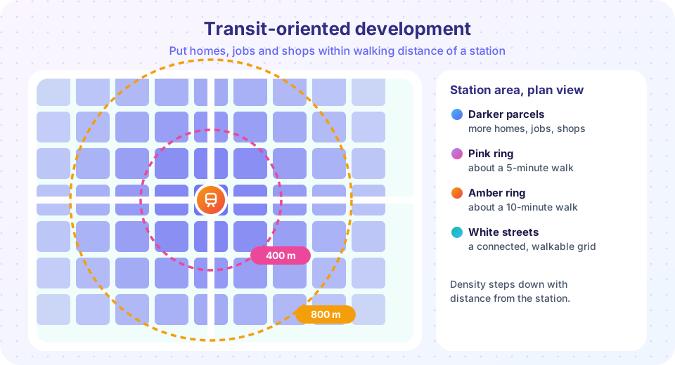
If you want people to use trains and buses, put homes, jobs and services within a short walk of stops. The architect and planner Peter Calthorpe gave the idea its name in the early 1990s, describing neighborhoods built around a station, with a core of shops and offices and homes within a comfortable walking distance, linked by connected streets.
Walk distances
A rule of thumb used in many TOD plans is that people will walk about 400 meters (a five-minute walk) to a bus stop and up to about 800 meters (ten minutes) to a rail station. At an average walking speed of about 5 kilometers per hour, 400 meters takes about five minutes and 800 meters about ten. Real distances depend on the street network: if streets curve and dead-end, a destination 400 meters away in a straight line might be 600 meters by foot. The ratio of network distance to straight-line distance is the circuity factor; in a perfect grid it averages about 1.27 (the 4/π figure we met in the ancient cities lesson).
Design principles
- Highest density near the station. More homes and jobs within reach means more riders.
- A mix of uses, so the station is busy all day and in both directions: commuters leaving in the morning and workers arriving.
- A connected, walkable street network with short blocks and direct paths to the station.
- Reduced parking, because land near the station is valuable and people there can use transit.
- Good public space at the station: a square, shops and shelter.
- Housing for many incomes. Because station areas become more desirable, planners need to guard against displacement of existing residents, a topic covered in Chapter 5.
Evidence and limits
Studies generally find that residents of TOD areas drive less and use transit more than similar residents elsewhere, though part of that is self-selection: people who prefer transit choose to live there. TOD also depends on good transit service. A dense development beside a train that runs once an hour will not reduce car use much. Finally, TOD needs political will and often a change to zoning, parking rules and street design.
Form-based codes
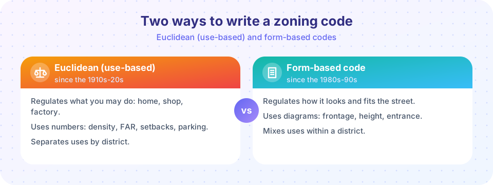
Conventional zoning regulates use and bulk: it asks what you will do on the land. A form-based code asks what the building will look like and how it meets the street. Its main tool is a set of diagrams and standards for building height, how close the building sits to the sidewalk, where entrances go and what kind of frontage (porch, shopfront, stoop) it has, while being relaxed about the exact mix of uses inside.
The approach was developed in the 1980s and 1990s by New Urbanist planners such as Andres Duany and Elizabeth Plater-Zyberk. A key idea is the transect, a gradient from rural to urban core (often six zones, T1 to T6) in which each zone has its own appropriate building types and street designs, from natural land to dense downtown. Supporters say form-based codes are easier to read, because a diagram shows what is allowed, and better at producing walkable streets. Critics say they can be complex to write and to administer, and a good form can hide a lack of affordable homes. Many cities now blend elements of both approaches.
Missing middle housing
The architect Daniel Parolek coined the term "missing middle" around 2010 for housing types that fit between single-family houses and large apartment blocks: duplexes, triplexes, townhouses, courtyard apartments and small mansion-style buildings. These were common in older neighborhoods but became illegal under later zoning that allowed only detached houses or large apartments. Allowing them again offers a gentle way to add homes in existing neighborhoods, near stations and shops, without towers.
The 15-minute city
The idea that daily needs should be within a short walk has a long history, and it was packaged as the 15-minute city by the Franco-Colombian scientist Carlos Moreno in the mid-2010s and promoted in Paris around 2020. The goal is that residents can reach most daily needs, such as groceries, schools, health care, parks and work or transit, within about 15 minutes on foot or by bike.
Supporters say it cuts car use, supports local business and improves health. Critics raise several concerns: that it is impractical for specialized jobs and services that cannot be in every neighborhood, that it might be used to restrict people's movement (a claim that planners and the proponents reject), and that making neighborhoods more attractive can raise housing costs. In practice, the idea is best read as a planning target for access, not a requirement that people stay within their neighborhood.
Common misconceptions
"Mixed use means a factory next to your house." Mixed-use zoning generally combines compatible uses, such as homes, offices, shops and cafes, and still keeps heavy industry apart.
"TOD only works with high-rises." Mid-rise, missing-middle and low-rise buildings can all fit a TOD, as long as the density is enough to support the service and the streets are walkable.
"The 15-minute city restricts where you can go." It is an accessibility goal: it asks for more options nearby, and does not forbid travel.
Try it
Compute the area you can reach on foot from a station for different walking times and street circuity. Change the speed or circuity to see how much a winding street pattern shrinks the walkshed.
Press Run (or Ctrl + Enter) to see the console output here.
No output.
The second widget is a rough 15-minute self-check for your own neighborhood. Enter distances in meters to eight kinds of places. The 15-minute walking distance is about 1,250 m at 5 km/h. It is a teaching demonstration, not an official index.
Check your understanding
Quick check · 5 questions
of 5 answered You scored / 5 · perfect!
-
1. At about 5 km/h, roughly how far do you walk in 10 minutes?
5 km/h is about 83 m per minute, so 10 minutes is about 830 m, rounded to 800 m. -
2. Who coined the term 'transit-oriented development' in the early 1990s?
Peter Calthorpe popularized TOD in the early 1990s. -
3. How does a form-based code differ from conventional zoning?
Form-based codes use diagrams and standards for height, frontage and entrances, with more flexible rules about use. -
4. 'Missing middle' housing refers to:
Daniel Parolek coined the term for house-scale buildings with multiple homes that became rare under later zoning. -
5. A common criticism of TOD evidence is:
People who prefer transit may choose to live near stations, so some of the effect is not caused by the place alone.
Summary
- Mixed use shortens trips, extends street activity and supports small business, if the mix is of compatible uses.
- TOD concentrates density, mix and walkable streets around stations within about 400 to 800 meters.
- Form-based codes regulate building form and street relationship; missing middle housing adds gentle density.
- The 15-minute city is an access goal with real benefits and real debates.
Next: Chapter 3 Review
Track your progress
Create a free account to tick off lessons and pick up where you left off on any device.
of Urban Planning lessons completed