


















Lesson 32 of 43 · Sustainability and Resilience
Hazards and adaptation
Understand flood probability, stormwater runoff, heat risk and the adaptation projects cities use, from Room for the River to sponge cities, with equity in mind.
On a calm day, a river valley looks like a good place to build: flat land, water nearby, fertile soil. That is exactly why so many cities began there, and also why so many of them flood. Hazards such as floods, heat waves, storms and wildfires are not new, but cities concentrate people and property in their path, and a changing climate is shifting how often and how severely some of them strike.
This lesson teaches the language of risk, including the often-misunderstood "100-year flood," shows how paving changes where rain goes, and tours real adaptation projects. It ends with the most important planning question about hazards: who is hurt most, and why?
What you will learn
- Define risk as hazard, exposure and vulnerability.
- Interpret annual-chance flood terms such as the "100-year flood."
- Calculate stormwater runoff with the rational method.
- Describe adaptation measures and real projects.
- Explain why disasters affect people unequally.
Key terms
Hazard: a physical event that could cause harm, such as a flood or heat wave.
Exposure: the people and assets located where a hazard can strike.
Vulnerability: how likely people or assets are to be harmed, depending on income, age, health, housing quality and support.
Annual exceedance probability (AEP): the chance that a flood of a given size or larger happens in any one year.
Runoff: rainwater that flows over land surfaces instead of soaking in.
Resilience: the ability of a city and its people to absorb shocks, adapt and recover, ideally improving rather than merely returning to the old state.
Risk is more than the hazard
Planners often write risk = hazard × exposure × vulnerability. A hurricane over empty ocean is a hazard but poses no risk. The same storm hitting a coastal city with thousands of homes in low areas creates exposure. And if many of those residents are elderly, poor or have no car to evacuate, vulnerability is high. This framing is useful because planners can act on all three terms: reduce the hazard (where possible), move or protect assets from exposure, and lower vulnerability through support, warning systems and better housing.
The 100-year flood, decoded
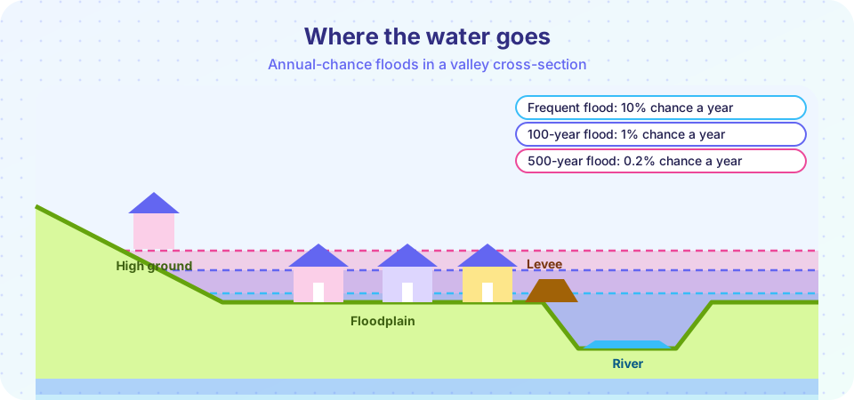
The phrase "100-year flood" is misleading, because it sounds as if such a flood happens once a century. It actually means a flood with a 1 percent chance of being equaled or exceeded in any given year. A 10-year flood has a 10 percent annual chance, and a 500-year flood has a 0.2 percent chance. Because each year is independent, the chance of at least one such flood over a period of n years is
P = 1 − (1 − p)^n
where p is the annual chance. For a 1 percent flood and a 30-year mortgage, P = 1 − 0.99^30, which is about 26 percent, more than one in four. That is why flood maps matter for homeowners, and why planners prefer to speak in annual chances. Climate change is raising the odds of heavy rainfall in many regions, so historical flood maps may understate current risk, and agencies are updating them.
What paving does to rain
When rain falls on a forest or meadow, much of it soaks into the soil or is taken up by plants. When it falls on roofs, roads and parking lots, it runs off quickly into drains and streams, producing sharper and larger floods. Engineers estimate peak runoff from a small catchment with the rational method:
Q = C × i × A / 360
Here Q is peak flow in cubic meters per second, C is the runoff coefficient (0 to 1, the share of rain that runs off), i is rainfall intensity in millimeters per hour and A is the area in hectares. Typical values of C range from about 0.1 to 0.3 for lawns and parks, to about 0.7 to 0.95 for roofs and pavement. If 10 hectares of pasture are converted to pavement during a 50 mm/hour storm, the peak flow can grow several times over. This is the physical reason that development without drainage planning worsens flooding downstream.
Adaptation: measures and real projects
Adaptation measures can be grouped into three strategies: protect (keep water or heat out), accommodate (change buildings and land use to live with hazards) and retreat (move people and assets away from the hazard).
- Room for the River (Netherlands, about 2006 to 2015) lowered flood levels by widening river channels, setting dikes back and creating spillways, giving the river more space in dozens of locations rather than only raising dikes.
- Rotterdam's water squares such as Benthemplein, opened in 2013, are plazas that act as public space most days and fill temporarily with rainwater during storms.
- Sponge city programs in China, launched with pilot cities in 2015, use permeable paving, green roofs, wetlands and storage to absorb and reuse rainwater. National targets aimed to absorb and reuse most rainfall in pilot areas, though results have varied in practice.
- Cooling and heat measures include street trees, cool roofs, shaded bus stops, public cooling centers and heat early-warning systems. In the Chicago heat wave of 1995, roughly 700 people died; the sociologist Eric Klinenberg showed that social isolation and neighborhood conditions strongly shaped who was at risk, which led many cities to build check-in programs for isolated residents.
- Managed retreat moves buildings or whole communities out of repeatedly flooded areas, often through voluntary buyouts. It is politically and emotionally difficult, but sometimes it is the most sensible option, as in some US flood-prone neighborhoods bought out after repeated floods.
Nature-based solutions such as restored wetlands, dunes and mangroves protect shorelines while supporting wildlife and recreation. They can be cheaper and more flexible than hard barriers in some places, though they need space and cannot stop the largest storm surges alone.
Equity: who bears the risk?
Hurricane Katrina struck New Orleans in 2005 and led to failures in the levee system. The disaster killed more than a thousand people in Louisiana, and the worst flooding hit low-lying neighborhoods where many Black and low-income residents lived; households without cars faced greater difficulty evacuating. Studies of disasters worldwide repeat the pattern: those with fewer resources face higher losses and recover more slowly. Resilience planning therefore asks not only "Will the building stand?" but also "Can the people who live there get warnings, leave safely, and afford to return?" Strong plans identify social vulnerability, involve residents in decisions and invest first where risk and need are highest.
Common misconceptions
"A 100-year flood happens once a century." It has a 1% chance each year, and could happen in consecutive years.
"Levees remove flood risk." Levees reduce the chance of flooding but can fail or be overtopped, and they can encourage building in areas that are then devastated if they fail. The remaining risk is called residual risk.
"Adaptation means giving up on cutting emissions." Both are needed: mitigation limits how bad things get, and adaptation handles what is unavoidable.
Try it
First explore how the chance of a flood builds up over the years.
Press Run (or Ctrl + Enter) to see the console output here.
No output.
Now compare runoff from a field and from pavement during a storm, using the rational method.
Press Run (or Ctrl + Enter) to see the result here.
Program input · what you'd type while the program runs
Type the answers before you press Run, one per line. Each time the program reads a line (with input()), it gets the next line from this box.
Check your understanding
Quick check · 5 questions
of 5 answered You scored / 5 · perfect!
-
1. What does a '100-year flood' mean?
The term describes annual probability, not a schedule. -
2. Roughly how likely is at least one 1% annual-chance flood in 30 years?
1 - 0.99^30 is about 0.26. -
3. Using Q = C x i x A / 360, what is Q for C = 0.9, i = 40 mm/h and A = 5 ha?
0.9 x 40 x 5 = 180; 180 / 360 = 0.5 m3/s. -
4. Which is a nature-based solution?
Wetlands, dunes and mangroves use natural processes to reduce risk. -
5. Why does vulnerability matter in disaster planning?
The same event harms different people differently, so plans target vulnerable groups.
Summary
- Risk combines hazard, exposure and vulnerability, and planners can act on each.
- Flood terms describe annual chance; over long periods the odds add up.
- Paving raises runoff; the rational method estimates peak flow.
- Adaptation includes protect, accommodate and retreat, with nature-based options.
- Equity is central: the most vulnerable need warnings, support and investment first.
Next: Chapter review
Track your progress
Create a free account to tick off lessons and pick up where you left off on any device.
of Urban Planning lessons completed